Cafe nearby Deserrano / Jurryt
Belgium
Cafe nearby Deserrano / Jurryt
Deserrano / Jurryt
Paul de Smet de Naeyerstraat 32, Middelkerke Bélgica
contacts phone
:
+32
Latitude:
51.1883442
, Longitude:
2.8180647
read more
nearest Cafe
Eethuis La Fonda
Paul de Smet de Naeyerstraat 32, Middelkerke
Cafe
read more
327 m
KOFFIE - EETHUIS BARISTA
Populierenlaan 20 Bus 2, Middelkerke
Cafe
read more
337 m
De Nieuwe Tuin
Kerkstraat 10, Middelkerke
Cafe
read more
378 m
De Smidse
Kerkstraat 4, Middelkerke
Cafe
read more
3.598 km
Sunset café
Middenlaan, Oostende
Cafe
read more
3.599 km
Van-Ver
Portiekenlaan 11, Middelkerke
Cafe
read more
3.665 km
De Strandjutter
Zeelaan 99-81, 8400, Oostende
Cafe
read more
4.538 km
Barrat / Dirk
Dorpsstraat 31, Leffinge
Cafe
read more
4.629 km
Wintertuin
Zeedijk 332-330, 8400, Oostende
Cafe
read more
4.855 km
Sfeercafe Monroe
Distellaan, Oostende
Cafe
read more
4.874 km
Ter Duinen
Essex Scottishlaan 28, Middelkerke
Cafe
read more
5.01 km
Coutteau / Hubert
Westendelaan 348, Middelkerke
Cafe
read more
5.132 km
De Vlinder
Nieuwpoortsesteenweg 673, Oostende
Cafe
read more
5.399 km
Taverne Pinta
Zeedijk 170, Oostende
Cafe
read more
5.399 km
S And T Trading
Zeedijk 170, Oostende
Cafe
read more
5.401 km
The Pinta Taverne
Zeedijk 170, Oostende
Cafe
read more
5.596 km
Café Vrolijk België
Aartshertogstraat 55, Oostende
Cafe
read more
5.683 km
Miroso
Zeedijk 153, Oostende
Cafe
read more
5.763 km
Café den AS
Nieuwpoortsesteenweg 180, Oostende
Cafe
read more
5.813 km
Lagrou / Marie-Catherine
Zeedijk 146, Oostende
Cafe
read more
6.021 km
Calise Brasserie,taverne Tearoom Snacks, gebak Wafels En Pannenkoeken
Zeedijk 137a, Oostende
Cafe
read more
6.089 km
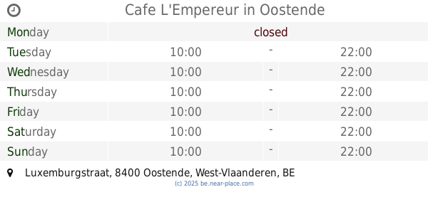
Cafe L'Empereur
Luxemburgstraat, Oostende
Cafe
read more
6.113 km
Degrijze / Marcella
Dorpsplein 36, Middelkerke
Cafe
read more
6.113 km
Cafe de Sterre
Dorpsplein 36, Middelkerke
Cafe
read more
6.485 km
't zwientje
Nieuwpoortlaan 40, Lombardsijde
Cafe
read more
📑
all categories
Accounting
Administrative area level 1
Administrative area level 2
Airport
Amusement park
Aquarium
Art gallery
Atm
Bakery
Bank
Bar
Beauty salon
Bicycle store
Book store
Bowling alley
Bus station
Cafe
Campground
Car dealer
Car rental
Car repair
Car wash
Casino
Cemetery
Church
City hall
Clothing store
Colloquial area
Convenience store
Country
Courthouse
Dentist
Department store
Doctor
Electrician
Electronics store
Embassy
Finance
Fire station
Florist
Food
Funeral home
Furniture store
Gas station
General contractor
Grocery or supermarket
Gym
Hair care
Hardware store
Health
Hindu Temple
Home goods store
Hospital
Insurance agency
Jewelry store
Laundry
Lawyer
Library
Light rail station
Liquor store
Local government office
Locality
Locksmith
Lodging
Meal delivery
Meal takeaway
Mosque
Movie rental
Movie theater
Moving company
Museum
Natural feature
Neighborhood
Night club
Painter
Park
Parking
Pet store
Pharmacy
Physiotherapist
Place of worship
Plumber
Point of interest
Police
Political
Post office
Premise
Real estate agency
Restaurant
Roofing contractor
Route
Rv park, camping
School
Shoe store
Shopping mall
Spa
Stadium
Storage
Store
Subpremise
Subway station
Supermarket
Synagogue
Taxi stand
Train station
Transit station
Travel agency
University
Veterinary care
Zoo
sublocality level 1
sublocality level 2
sublocality level 3
↑