Cafe nearby Deprez / Marie-Rose
Belgium
Cafe nearby Deprez / Marie-Rose
Deprez / Marie-Rose
Vredelaan 68, Torhout België
contacts phone
:
+32
Latitude:
51.0645666
, Longitude:
3.0935375
read more
nearest Cafe
487 m
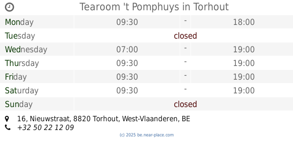
Tearoom 't Pomphuys
Nieuwstraat 16, Torhout
Cafe
read more
497 m
Van Den Bogaerde / Pascal
Fraeysstraat 4, Torhout
Cafe
read more
547 m
Foelard
Markt 5, Torhout
Cafe
read more
552 m
La Plaza
Markt 2-32, 8820, Torhout
Cafe
read more
574 m
Mortier / Diana
Burg 10, Torhout
Cafe
read more
586 m
foyer
Torhout
Cafe
read more
598 m
Cafe De Sportwereld
Burg 31, Torhout
Cafe
read more
608 m
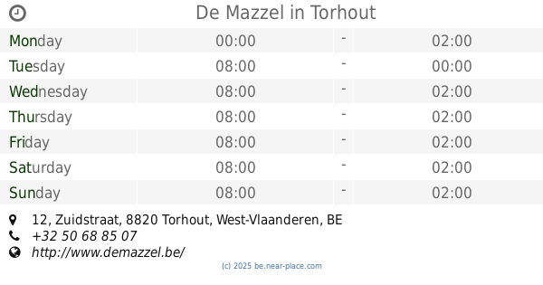
De Mazzel
Zuidstraat 12, Torhout
Cafe
read more
613 m
Jeugdhuis De Troubadour
Zuidstraat 14, Torhout
Cafe
read more
656 m
Smoking Cue
Hofstraat 14, Torhout
Cafe
read more
668 m
Passage Fiems
Kortemarkstraat 1/A, Torhout
Cafe
read more
752 m
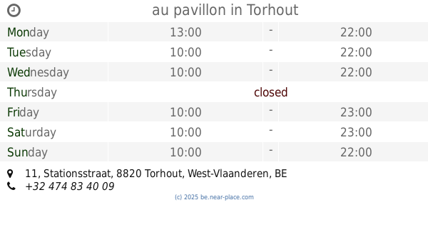
au pavillon
Stationsstraat 11, Torhout
Cafe
read more
771 m
Fifty-Seven
Stationsstraat 10, Torhout
Cafe
read more
788 m
Café Flandria
Stationsstraat 14, Torhout
Cafe
read more
791 m
Apropoo
Stationsstraat 19, Torhout
Cafe
read more
901 m
Devos / Hans
Oostendestraat 223, Torhout
Cafe
read more
1.226 km
Cafetaria Kiboe Kinderboerderij d'Oude Smelterij
Ieperse Heerweg, Torhout
Cafe
read more
1.989 km
Danscafé
Ieperse Heerweg 13, Torhout
Cafe
read more
2.407 km
Eet en praatcafé Drie Koningen Torhout
Aartrijkestraat 217, Torhout
Cafe
read more
2.414 km
Drie Koningen
Aartrijkestraat 217, Torhout
Cafe
read more
3.165 km
Café-Feestzaal Rozeveld
Rozeveldstraat 2, Torhout
Cafe
read more
4.561 km
Markhove
Ichtegemstraat 90, Kortemark
Cafe
read more
5.028 km
Cafe T Wit Paard
Statieplaats 12, Lichtervelde
Cafe
read more
5.245 km
De Notelaar
Marktplaats 11, Lichtervelde
Cafe
read more
5.26 km
Cafe Brigand
Hoogstraat 2, Lichtervelde
Cafe
read more
📑
all categories
Accounting
Administrative area level 1
Administrative area level 2
Airport
Amusement park
Aquarium
Art gallery
Atm
Bakery
Bank
Bar
Beauty salon
Bicycle store
Book store
Bowling alley
Bus station
Cafe
Campground
Car dealer
Car rental
Car repair
Car wash
Casino
Cemetery
Church
City hall
Clothing store
Colloquial area
Convenience store
Country
Courthouse
Dentist
Department store
Doctor
Electrician
Electronics store
Embassy
Finance
Fire station
Florist
Food
Funeral home
Furniture store
Gas station
General contractor
Grocery or supermarket
Gym
Hair care
Hardware store
Health
Hindu Temple
Home goods store
Hospital
Insurance agency
Jewelry store
Laundry
Lawyer
Library
Light rail station
Liquor store
Local government office
Locality
Locksmith
Lodging
Meal delivery
Meal takeaway
Mosque
Movie rental
Movie theater
Moving company
Museum
Natural feature
Neighborhood
Night club
Painter
Park
Parking
Pet store
Pharmacy
Physiotherapist
Place of worship
Plumber
Point of interest
Police
Political
Post office
Premise
Real estate agency
Restaurant
Roofing contractor
Route
Rv park, camping
School
Shoe store
Shopping mall
Spa
Stadium
Storage
Store
Subpremise
Subway station
Supermarket
Synagogue
Taxi stand
Train station
Transit station
Travel agency
University
Veterinary care
Zoo
sublocality level 1
sublocality level 2
sublocality level 3
↑