Cafe nearby Depoorter-Lagae / S.
Belgium
Cafe nearby Depoorter-Lagae / S.
Depoorter-Lagae / S.
Burgemeester Bertenplein 3, Poperinge Belgium
contacts phone
:
+32
Latitude:
50.8547255
, Longitude:
2.7254473
read more
nearest Cafe
44 m
My Place
Kerkstraat 1, Poperinge
Cafe
read more
102 m
't Fabriekje Bvba
Grote Markt 15, Poperinge
Cafe
read more
142 m
Hotel de la Paix
Grote Markt 20, Poperinge
Cafe
read more
143 m
Petit PopUp EEKAA-dorp en café
Grote Markt 29, Poperinge
Cafe
read more
204 m
Cafe Moderne
Gasthuisstraat 64, Poperinge
Cafe
read more
228 m
De Gilde
Rekhof 11, Poperinge
Cafe
read more
233 m
Paelinck / Stefaan
Rekhof 18, Poperinge
Cafe
read more
241 m
De Wijngaard
Casselstraat 32, Poperinge
Cafe
read more
295 m
D'n Hommelzak
Paardenmarkt 10/B, Poperinge
Cafe
read more
817 m
Geeraerd / Patrick
Veurnestraat 132, Poperinge
Cafe
read more
4.176 km
Maerten-Catteeuw / M.
Kapellestraat 5, Poperinge
Cafe
read more
4.253 km
In De Ster
Kapellestraat 5, Poperinge
Cafe
read more
4.485 km
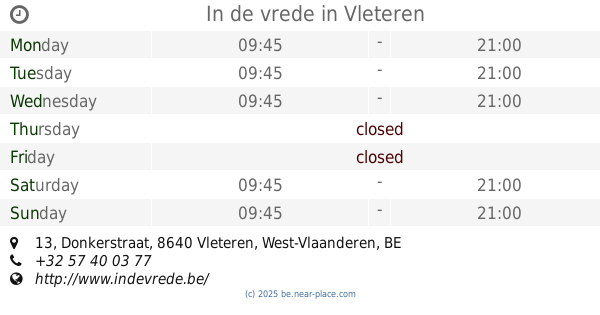
In de vrede
Donkerstraat 13, Vleteren
Cafe
read more
4.492 km
De Gouden Brander
Poperingseweg 677, Ieper
Cafe
read more
5.027 km
De Helleketel
Vuileseulestraat 6, Poperinge
Cafe
read more
5.048 km
De Kinderbrouwerij
Reningelstplein 5a, Poperinge
Cafe
read more
6.747 km
Café De Slachter
Kerkplein, Ieper
Cafe
read more
6.747 km
Catteeu / Cecilia
Elverdingestraat 2, Vleteren
Cafe
read more
8.753 km
Vanacker / Franky
Dikkebusstraat 135, Heuvelland
Cafe
read more
8.932 km
Demey-Gouwy Mw / A.
Dikkebusseweg 401
Cafe
read more
10.961 km
De Lockedyze
Kemmelstraat 40, Heuvelland
Cafe
read more
11.005 km
Eetkaffee Steenstraete
Provincieweg 2, Langemark-Poelkapelle
Cafe
read more
11.597 km
Versavel / Mario
Kalfvaart 19, Ieper
Cafe
read more
12.843 km
A la ville de lille
1 Rue de Lille, Bailleul
Cafe
read more
13.76 km
Garreyn / Diane
Ieperstraat 123, Heuvelland
Cafe
read more
📑
all categories
Accounting
Administrative area level 1
Administrative area level 2
Airport
Amusement park
Aquarium
Art gallery
Atm
Bakery
Bank
Bar
Beauty salon
Bicycle store
Book store
Bowling alley
Bus station
Cafe
Campground
Car dealer
Car rental
Car repair
Car wash
Casino
Cemetery
Church
City hall
Clothing store
Colloquial area
Convenience store
Country
Courthouse
Dentist
Department store
Doctor
Electrician
Electronics store
Embassy
Finance
Fire station
Florist
Food
Funeral home
Furniture store
Gas station
General contractor
Grocery or supermarket
Gym
Hair care
Hardware store
Health
Hindu Temple
Home goods store
Hospital
Insurance agency
Jewelry store
Laundry
Lawyer
Library
Light rail station
Liquor store
Local government office
Locality
Locksmith
Lodging
Meal delivery
Meal takeaway
Mosque
Movie rental
Movie theater
Moving company
Museum
Natural feature
Neighborhood
Night club
Painter
Park
Parking
Pet store
Pharmacy
Physiotherapist
Place of worship
Plumber
Point of interest
Police
Political
Post office
Premise
Real estate agency
Restaurant
Roofing contractor
Route
Rv park, camping
School
Shoe store
Shopping mall
Spa
Stadium
Storage
Store
Subpremise
Subway station
Supermarket
Synagogue
Taxi stand
Train station
Transit station
Travel agency
University
Veterinary care
Zoo
sublocality level 1
sublocality level 2
sublocality level 3
↑