Cafe nearby De Rustberg
Belgium
Cafe nearby De Rustberg
De Rustberg
Scheestraat 129, Dilbeek Belgien
contacts phone
:
+32
Latitude:
50.8284389
, Longitude:
4.1972746
read more
nearest Cafe
1.965 km
Van Den Eeckhoudt / Ingrid
Bullenbergstraat 15, Dilbeek
Cafe
read more
1.984 km
Valkeniers / Michel
Kouterstraat 83, Dilbeek
Cafe
read more
2.353 km
De Welkom
Jan De Trochstraat 137, Dilbeek
Cafe
read more
2.579 km
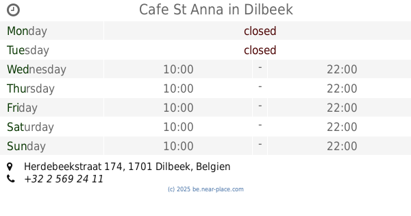
Cafe St Anna
Herdebeekstraat 174
Cafe
read more
2.844 km
Van Mijn Dromen
Kraanstraat 104, Dilbeek
Cafe
read more
3.788 km
Millennium Café
Assesteenweg 236, Lennik
Cafe
read more
3.792 km
Vandersmissen / Johan
Alfred Algoetstraat 12, Lennik
Cafe
read more
3.923 km
Nacht van de Grote Dorst 2016
Kerkstraat 55, Dilbeek
Cafe
read more
4.27 km
Massaert / Paulette
Domstraat 22, Vlezenbeek
Cafe
read more
4.272 km
Bodegem City
St-Mart-Bodeg) 80, Molenstraat
Cafe
read more
4.279 km
Caffe Con Latte
Kerkwegstraat 7, Dilbeek
Cafe
read more
4.492 km
Café Geen Idee
Molenbergstraat 5, Dilbeek
Cafe
read more
4.595 km
Vagevuur
Vlezenbeeklaan 91, Sint-Pieters-Leeuw
Cafe
read more
4.757 km
De Zaal
d'Arconatistraat 20, Dilbeek
Cafe
read more
4.76 km
De Living
d'Arconatistraat 20, Dilbeek
Cafe
read more
4.852 km
Anckaert / Gunther
Kerkstraat 2, Roosdaal
Cafe
read more
4.868 km
De Waeterheren
Gemeentehuisstraat 1, Ternat
Cafe
read more
4.902 km
Café Setup
Statiestraat 20, Ternat
Cafe
read more
5.21 km
De Belleman
Gemeenteplein 10, Dilbeek
Cafe
read more
5.372 km
Café De Mooie Molen
Weverstraat 39, Roosdaal
Cafe
read more
5.506 km
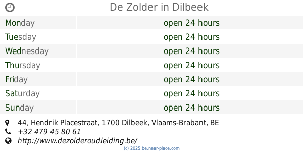
De Zolder
Hendrik Placestraat 44, Dilbeek
Cafe
read more
5.753 km
De Meiboom
Elegemstraat 50, Dilbeek
Cafe
read more
5.767 km
Café N8M=
Kerkpleinweg 9, Ternat
Cafe
read more
6.303 km
Wie Anders
Bosstraat 87, Groot-Bijgaarden
Cafe
read more
6.798 km
De Lantaarn
Galgstraat 33, Sint-Pieters-Leeuw
Cafe
read more
📑
all categories
Accounting
Administrative area level 1
Administrative area level 2
Airport
Amusement park
Aquarium
Art gallery
Atm
Bakery
Bank
Bar
Beauty salon
Bicycle store
Book store
Bowling alley
Bus station
Cafe
Campground
Car dealer
Car rental
Car repair
Car wash
Casino
Cemetery
Church
City hall
Clothing store
Colloquial area
Convenience store
Country
Courthouse
Dentist
Department store
Doctor
Electrician
Electronics store
Embassy
Finance
Fire station
Florist
Food
Funeral home
Furniture store
Gas station
General contractor
Grocery or supermarket
Gym
Hair care
Hardware store
Health
Hindu Temple
Home goods store
Hospital
Insurance agency
Jewelry store
Laundry
Lawyer
Library
Light rail station
Liquor store
Local government office
Locality
Locksmith
Lodging
Meal delivery
Meal takeaway
Mosque
Movie rental
Movie theater
Moving company
Museum
Natural feature
Neighborhood
Night club
Painter
Park
Parking
Pet store
Pharmacy
Physiotherapist
Place of worship
Plumber
Point of interest
Police
Political
Post office
Premise
Real estate agency
Restaurant
Roofing contractor
Route
Rv park, camping
School
Shoe store
Shopping mall
Spa
Stadium
Storage
Store
Subpremise
Subway station
Supermarket
Synagogue
Taxi stand
Train station
Transit station
Travel agency
University
Veterinary care
Zoo
sublocality level 1
sublocality level 2
sublocality level 3
↑