Cafe nearby Cafe Averroès
Belgium
Cafe nearby Cafe Averroès
Cafe Averroès
Sint-Jans-Molenbeek Belgium
contacts phone
:
+32
Latitude:
50.8606193
, Longitude:
4.3404703
read more
nearest Cafe
53 m
F.C. Jeunesse-Molenbeek
Boulevard Leopold II 84, Molenbeek-Saint-Jean
Cafe
read more
134 m
Liberty Cafe
Boulevard Leopold II 131, Molenbeek-Saint-Jean
Cafe
read more
309 m
Tandem Fiets Café Vélo (2018)
Rue Ulens 89, Molenbeek-Saint-Jean
Cafe
read more
420 m
La Rose Blanche
Steenweg op Merchtem 53, Molenbeek-Saint-Jean
Cafe
read more
456 m
Sunshine Bar
Rue de Ribaucourt 220, Molenbeek-Saint-Jean
Cafe
read more
588 m
Le Phare du Kanaal
Quai des Charbonnages 40, Molenbeek-Saint-Jean
Cafe
read more
713 m
Ben's cafe
Rue de l'Eglise Sainte-Anne 110, Koekelberg
Cafe
read more
720 m
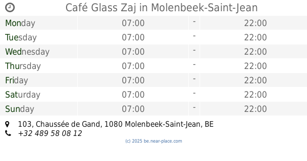
Café Glass Zaj
Chaussée de Gand 103, Molenbeek-Saint-Jean
Cafe
read more
791 m
Chicha Lounge Dubai
Boulevard d'Anvers 36, Bruxelles
Cafe
read more
836 m
Midpoint
Rue de Flandre 189, Bruxelles
Cafe
read more
836 m
Midpoint
Vlaamsesteenweg 189, Brussel
Cafe
read more
871 m
Cafe de la rue
Kolomstraat 30, Sint-Jans-Molenbeek
Cafe
read more
877 m
Mundy
Havenlaan 86C, Brussel
Cafe
read more
877 m
Mundy
Avenue du Port 86C, Bruxelles
Cafe
read more
926 m
Kumiko
Aalststraat 7, Brussel
Cafe
read more
937 m
Café Merlo
Baksteenkaai 80, Brussel
Cafe
read more
963 m
ViaVia Café Brussels
Baksteenkaai 74, Brussel
Cafe
read more
963 m
ViaVia Café Brussels
Quai aux Briques 74, Bruxelles
Cafe
read more
984 m
Chalet
1080, Avenue Mahatma Gandhi 3, Molenbeek-Saint-Jean
Cafe
read more
992 m
Barbeton
Antoine Dansaertstraat 114, Brussel
Cafe
read more
1.03 km
Urban Therapy
Vlaamsesteenweg 84, Brussel
Cafe
read more
1.096 km
Cafe Velvet Brussels
Quai au Bois à Brûler 27, Bruxelles
Cafe
read more
1.237 km
Le Boulevard
Boulevard Emile Jacqmain 36, Bruxelles
Cafe
read more
1.251 km
Aazar club
Rue Vander Elst 8, Rue Des Hirondelles 7, Bruxelles
Cafe
read more
1.36 km
Churros Valyser
Rue Saint-Michel 15, Bruxelles
Cafe
read more
📑
all categories
Accounting
Administrative area level 1
Administrative area level 2
Airport
Amusement park
Aquarium
Art gallery
Atm
Bakery
Bank
Bar
Beauty salon
Bicycle store
Book store
Bowling alley
Bus station
Cafe
Campground
Car dealer
Car rental
Car repair
Car wash
Casino
Cemetery
Church
City hall
Clothing store
Colloquial area
Convenience store
Country
Courthouse
Dentist
Department store
Doctor
Electrician
Electronics store
Embassy
Finance
Fire station
Florist
Food
Funeral home
Furniture store
Gas station
General contractor
Grocery or supermarket
Gym
Hair care
Hardware store
Health
Hindu Temple
Home goods store
Hospital
Insurance agency
Jewelry store
Laundry
Lawyer
Library
Light rail station
Liquor store
Local government office
Locality
Locksmith
Lodging
Meal delivery
Meal takeaway
Mosque
Movie rental
Movie theater
Moving company
Museum
Natural feature
Neighborhood
Night club
Painter
Park
Parking
Pet store
Pharmacy
Physiotherapist
Place of worship
Plumber
Point of interest
Police
Political
Post office
Premise
Real estate agency
Restaurant
Roofing contractor
Route
Rv park, camping
School
Shoe store
Shopping mall
Spa
Stadium
Storage
Store
Subpremise
Subway station
Supermarket
Synagogue
Taxi stand
Train station
Transit station
Travel agency
University
Veterinary care
Zoo
sublocality level 1
sublocality level 2
sublocality level 3
↑