Cafe nearby Bij Nuyt - Pletinckx / Jeanine
Belgium
Cafe nearby Bij Nuyt - Pletinckx / Jeanine
Bij Nuyt - Pletinckx / Jeanine
Heidestraat 139, Ternat Belgium
contacts phone
:
+32
Latitude:
50.8672264
, Longitude:
4.134616
read more
nearest Cafe
587 m
Van Den Eeckhoudt / Rita
Heidestraat 69, Ternat
Cafe
read more
1.074 km
Café Devenderp
Loddershoekstraat 36-50, Ternat
Cafe
read more
1.086 km
Platteau / Paula
Loddershoekstraat 44, Ternat
Cafe
read more
1.548 km
De Meiboom
Meersstraat 124, Ternat
Cafe
read more
1.643 km
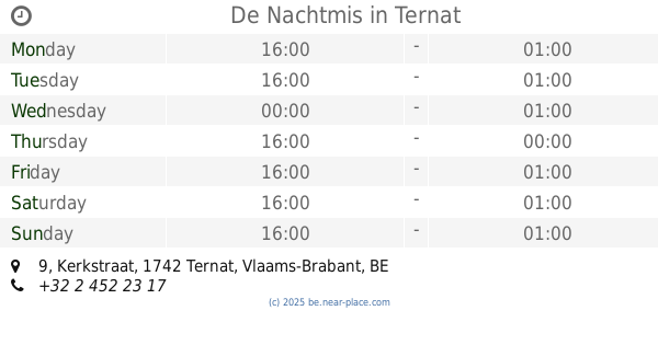
De Nachtmis
Kerkstraat 9, Ternat
Cafe
read more
1.645 km
Café N8M=
Kerkpleinweg 9, Ternat
Cafe
read more
1.708 km
Cafe Den Dries
Meersstraat 25, Ternat
Cafe
read more
1.715 km
De Oude Web
Meersstraat 48, 1742 Ternat, België
Cafe
read more
1.849 km
Café De Mooie Molen
Weverstraat 39, Roosdaal
Cafe
read more
1.971 km
Café-terras 't Lof
Kerkstraat 2, Borchtlombeek - Roosdaal
Cafe
read more
1.975 km
Anckaert / Gunther
Kerkstraat 2, Roosdaal
Cafe
read more
2.163 km
Weinstube-jackall
Populierenlaan 14, Liedekerke
Cafe
read more
2.375 km
Meerstraat
Steenvoordestraat, Ternat
Cafe
read more
2.932 km
De Welkom
Muilenstraat 124, Liedekerke
Cafe
read more
2.952 km
Café Setup
Statiestraat 20, Ternat
Cafe
read more
2.957 km
De Smedt / Josée
Assesteenweg 40, Ternat
Cafe
read more
3.197 km
Wauters / Josiane
Strijtemplein 6, Roosdaal
Cafe
read more
3.775 km
Boerenschuur
Daalstraat 5, Affligem
Cafe
read more
3.843 km
Café Natekes
Daalstraat 8, Affligem
Cafe
read more
4.054 km
Cantine De Leeuwkens
Denderweg 1, Affligem
Cafe
read more
4.086 km
the Cats
Daalstraat, Affligem
Cafe
read more
4.275 km
Van Den Eeckhoudt / Ingrid
Bullenbergstraat 15, Dilbeek
Cafe
read more
4.648 km
Café 't Boerken
Kespier 20, Asse
Cafe
read more
4.899 km
't Pamels Koffiehuisje
Pamelse Klei 9, Roosdaal
Cafe
read more
5.365 km
De Vlamoven
Steenweg 359, Denderleeuw
Cafe
read more
📑
all categories
Accounting
Administrative area level 1
Administrative area level 2
Airport
Amusement park
Aquarium
Art gallery
Atm
Bakery
Bank
Bar
Beauty salon
Bicycle store
Book store
Bowling alley
Bus station
Cafe
Campground
Car dealer
Car rental
Car repair
Car wash
Casino
Cemetery
Church
City hall
Clothing store
Colloquial area
Convenience store
Country
Courthouse
Dentist
Department store
Doctor
Electrician
Electronics store
Embassy
Finance
Fire station
Florist
Food
Funeral home
Furniture store
Gas station
General contractor
Grocery or supermarket
Gym
Hair care
Hardware store
Health
Hindu Temple
Home goods store
Hospital
Insurance agency
Jewelry store
Laundry
Lawyer
Library
Light rail station
Liquor store
Local government office
Locality
Locksmith
Lodging
Meal delivery
Meal takeaway
Mosque
Movie rental
Movie theater
Moving company
Museum
Natural feature
Neighborhood
Night club
Painter
Park
Parking
Pet store
Pharmacy
Physiotherapist
Place of worship
Plumber
Point of interest
Police
Political
Post office
Premise
Real estate agency
Restaurant
Roofing contractor
Route
Rv park, camping
School
Shoe store
Shopping mall
Spa
Stadium
Storage
Store
Subpremise
Subway station
Supermarket
Synagogue
Taxi stand
Train station
Transit station
Travel agency
University
Veterinary care
Zoo
sublocality level 1
sublocality level 2
sublocality level 3
↑