Bar nearby Lebowski's
Belgium
Bar nearby Lebowski's
Lebowski's
Boomgaardstraat 350, Antwerpen Belgium
contacts phone
:
+32
Latitude:
51.2001118
, Longitude:
4.430665
read more
nearest Bar
281 m
Marcel Bar - Spirits & Cigars
Cogels-Osylei 88, Berchem (Antwerpen)
Bar
read more
358 m
Stanny
Stanleystraat 1, Antwerpen
Bar
read more
369 m
Verzamellocatie Skanna
Borsbeeksebrug 1001, Antwerpen
Bar
read more
381 m
Café Het Anker
Generaal Drubbelstraat 95, Antwerpen
Bar
read more
602 m
Gitanes
TRAMPLEIN 3-4, Antwerpen
Bar
read more
680 m
Bar Vert
Helenalei 2, Antwerpen
Bar
read more
684 m
Plantage
Draakstraat 28, Antwerpen
Bar
read more
739 m
Bar Salon
Dageraadplaats 2, Antwerpen
Bar
read more
1.012 km
Den Tijl
Plantin en Moretuslei 212, Antwerpen
Bar
read more
1.134 km
Cantaloop
Onze-Lieve-Vrouwstraat 1, Antwerpen
Bar
read more
1.695 km
Chillbox
Turnhoutsebaan 106, Antwerpen
Bar
read more
1.772 km
Bar'Jo
Troyentenhoflaan 53, Antwerpen
Bar
read more
1.773 km
Plaza Real
Kattenberg 93, Antwerpen
Bar
read more
1.795 km
FLamingo
Laar 10, Antwerpen
Bar
read more
1.94 km
Koersk
Mechelsesteenweg 15, Mortsel
Bar
read more
2.11 km
Loyens Rudi Pub Breda
Statiestraat 50, Antwerpen
Bar
read more
2.124 km
Italia '90
Breydelstraat 31, Antwerpen
Bar
read more
2.136 km
Kelly's Irish Pub
De Keyserlei 27, Antwerpen
Bar
read more
2.141 km
the Popcorn
De Keyserlei 25, Antwerpen
Bar
read more
2.142 km
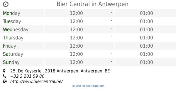
Bier Central
De Keyserlei 25, Antwerpen
Bar
read more
2.152 km
Chiquita Fruitbar
De Keyserlei 11, Antwerpen
Bar
read more
2.17 km
Izzy Maze
Leopoldplaats 2, Antwerpen
Bar
read more
2.221 km
Barpourboire
Sint-Jorispoort 21, Antwerpen
Bar
read more
2.322 km
Boer van Tienen
Mechelseplein 6, Antwerpen
Bar
read more
2.582 km
Strandhof
Oudaan 14, Antwerpen
Bar
read more
📑
all categories
Accounting
Administrative area level 1
Administrative area level 2
Airport
Amusement park
Aquarium
Art gallery
Atm
Bakery
Bank
Bar
Beauty salon
Bicycle store
Book store
Bowling alley
Bus station
Cafe
Campground
Car dealer
Car rental
Car repair
Car wash
Casino
Cemetery
Church
City hall
Clothing store
Colloquial area
Convenience store
Country
Courthouse
Dentist
Department store
Doctor
Electrician
Electronics store
Embassy
Finance
Fire station
Florist
Food
Funeral home
Furniture store
Gas station
General contractor
Grocery or supermarket
Gym
Hair care
Hardware store
Health
Hindu Temple
Home goods store
Hospital
Insurance agency
Jewelry store
Laundry
Lawyer
Library
Light rail station
Liquor store
Local government office
Locality
Locksmith
Lodging
Meal delivery
Meal takeaway
Mosque
Movie rental
Movie theater
Moving company
Museum
Natural feature
Neighborhood
Night club
Painter
Park
Parking
Pet store
Pharmacy
Physiotherapist
Place of worship
Plumber
Point of interest
Police
Political
Post office
Premise
Real estate agency
Restaurant
Roofing contractor
Route
Rv park, camping
School
Shoe store
Shopping mall
Spa
Stadium
Storage
Store
Subpremise
Subway station
Supermarket
Synagogue
Taxi stand
Train station
Transit station
Travel agency
University
Veterinary care
Zoo
sublocality level 1
sublocality level 2
sublocality level 3
↑