Bar nearby Foyer Meurice
Belgium
Bar nearby Foyer Meurice
Foyer Meurice
Rue Raymond Ebrant 45, Anderlecht Belgium
contacts phone
:
+32
Latitude:
50.8159384
, Longitude:
4.2920885
read more
nearest Bar
594 m
brasserie Modern G.H.G.D.
Chaussée de Mons 1165, Anderlecht
Bar
read more
594 m
brasserie Modern G.H.G.D.
Bergensesteenweg 1165, Anderlecht
Bar
read more
733 m
prenses
Boulevard International, Anderlecht
Bar
read more
973 m
Le Fourquet Sprl
Quai d'Aa 1, Bruxelles
Bar
read more
995 m
Le Bar A Salon
Anderlecht
Bar
read more
1.359 km
pc nic nghe mariniers
Olympische dreef 11, Anderlecht
Bar
read more
1.466 km
Cafe Bar Gaulois
Bergensesteenweg 880, Anderlecht
Bar
read more
1.664 km
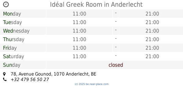
Idéal Greek Room
Avenue Gounod 78, Anderlecht
Bar
read more
1.829 km
Michel / Ventura
Place Saint-Denis 17, Forest
Bar
read more
1.856 km
Morning Star
Chaussée de Neerstalle 177, Bruxelles
Bar
read more
1.9 km
Le Faubourg Saint Honorė
Abbaye 1, Forest
Bar
read more
1.96 km
Wood Cafe
2,, Rond-Point du Meir 1, Anderlecht
Bar
read more
1.972 km
L'Allumette
Rue de la Teinturerie 16, Forest
Bar
read more
1.995 km
Basin & Marot
Brandstoffenstraat 53, Vorst
Bar
read more
2.19 km
Le transfer VII
Avenue d'Itterbeek 40, Anderlecht
Bar
read more
2.47 km
28 30 Bar
/30,, Avenue du Globe 28, Forest
Bar
read more
2.474 km
Black Devils Vorst
Roosendaalstraat 2, Vorst
Bar
read more
2.496 km
Le Sprok
Rue du Broeck, Anderlecht
Bar
read more
2.587 km
CHEZ LUDO
Eikelstraat 81, Vorst
Bar
read more
2.607 km
Royal Uccle Sport THC
Chaussée de Ruisbroek 18, Uccle
Bar
read more
2.712 km
Dekkera
Pierre Decosterstraat 109, Vorst
Bar
read more
2.847 km
Relax Bar
Bergensesteenweg 408-410, Anderlecht
Bar
read more
2.856 km
Bar Duden
Gabriel Faurélaan 4, Vorst
Bar
read more
2.888 km
Khalti Samira
Wayezstraat 1-53, Anderlecht
Bar
read more
2.94 km
JK Oosthoek
H. Theresialaan 21-79, Dilbeek
Bar
read more
📑
all categories
Accounting
Administrative area level 1
Administrative area level 2
Airport
Amusement park
Aquarium
Art gallery
Atm
Bakery
Bank
Bar
Beauty salon
Bicycle store
Book store
Bowling alley
Bus station
Cafe
Campground
Car dealer
Car rental
Car repair
Car wash
Casino
Cemetery
Church
City hall
Clothing store
Colloquial area
Convenience store
Country
Courthouse
Dentist
Department store
Doctor
Electrician
Electronics store
Embassy
Finance
Fire station
Florist
Food
Funeral home
Furniture store
Gas station
General contractor
Grocery or supermarket
Gym
Hair care
Hardware store
Health
Hindu Temple
Home goods store
Hospital
Insurance agency
Jewelry store
Laundry
Lawyer
Library
Light rail station
Liquor store
Local government office
Locality
Locksmith
Lodging
Meal delivery
Meal takeaway
Mosque
Movie rental
Movie theater
Moving company
Museum
Natural feature
Neighborhood
Night club
Painter
Park
Parking
Pet store
Pharmacy
Physiotherapist
Place of worship
Plumber
Point of interest
Police
Political
Post office
Premise
Real estate agency
Restaurant
Roofing contractor
Route
Rv park, camping
School
Shoe store
Shopping mall
Spa
Stadium
Storage
Store
Subpremise
Subway station
Supermarket
Synagogue
Taxi stand
Train station
Transit station
Travel agency
University
Veterinary care
Zoo
sublocality level 1
sublocality level 2
sublocality level 3
↑