Bar nearby De Winning
Belgium
Bar nearby De Winning
De Winning
Hannuitstraat 9, Gingelom Belgium
contacts phone
:
+32
Latitude:
50.719553
, Longitude:
5.1274201
read more
nearest Bar
2.266 km
Le Passe-temps
Rue du Paradis 3, Cras-Avernas
Bar
read more
4.439 km
Bar Le Chalet
Molenbergstraat 52, Landen
Bar
read more
4.737 km
Taverne Rufferdinge
Molenbergstraat 4, Landen
Bar
read more
4.938 km
Carré
Marktplein 2, Landen
Bar
read more
5.359 km
Café Argus
Slachthuisplein 1, Landen
Bar
read more
6.361 km
Au Petit Caprice
Rue Albert 1er 74, Hannut
Bar
read more
6.619 km
Motor club M.T.C.Realbikers
Gemeenteplein 24, Sint-Truiden
Bar
read more
10.077 km
Maho Bruno
Dungelstraat 13, Halle-Booiehoven
Bar
read more
11.225 km
Jeugdhuis EXPO
Gootstraat 33, Sint-Truiden
Bar
read more
11.494 km
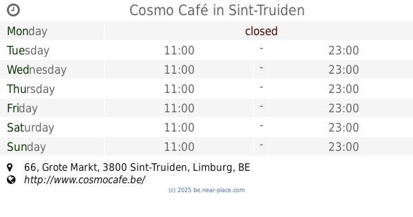
Cosmo Café
Grote Markt 66, Sint-Truiden
Bar
read more
11.498 km
Twenty Two Coffee
Grote Markt 55, Sint-Truiden
Bar
read more
11.635 km
Nancy's Lounge
Diesterstraat 23, Sint-Truiden
Bar
read more
12.807 km
De Twee Leeuwkes
Grote Markt 26, Zoutleeuw
Bar
read more
13.585 km
Bistro Het Vinne - De Winning
Ossenwegstraat 70, Zoutleeuw
Bar
read more
16.391 km
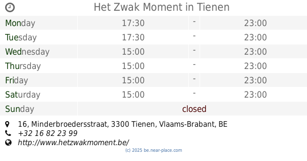
Het Zwak Moment
Minderbroedersstraat 16, Tienen
Bar
read more
16.393 km
COSTA LOODS
Ooievaarstraat 30, Tienen
Bar
read more
16.435 km
Theatercafe Tienen
Sint-Jorisplein 2, Tienen
Bar
read more
16.503 km
Bar-Bier
Kalkmarkt 3, Tienen
Bar
read more
16.522 km
Ottenbourg Wim Gaby
Broekstraat 1, Tienen
Bar
read more
16.523 km
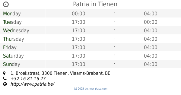
Patria
11,, Broekstraat 1, Tienen
Bar
read more
16.528 km
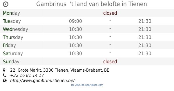
Gambrinus 't land van belofte
Grote Markt 22, Tienen
Bar
read more
16.533 km
Costa Hoppa
Broekstraat 23, Tienen
Bar
read more
16.635 km
Schuyten / Jürgen
Grote Markt 43, Tienen
Bar
read more
16.718 km
3L Buurtkantine
Leuvensestraat 20, Tienen
Bar
read more
19.645 km
O Bar
Rue Albert Ier 249, Saint-Georges-sur-Meuse
Bar
read more
📑
all categories
Accounting
Administrative area level 1
Administrative area level 2
Airport
Amusement park
Aquarium
Art gallery
Atm
Bakery
Bank
Bar
Beauty salon
Bicycle store
Book store
Bowling alley
Bus station
Cafe
Campground
Car dealer
Car rental
Car repair
Car wash
Casino
Cemetery
Church
City hall
Clothing store
Colloquial area
Convenience store
Country
Courthouse
Dentist
Department store
Doctor
Electrician
Electronics store
Embassy
Finance
Fire station
Florist
Food
Funeral home
Furniture store
Gas station
General contractor
Grocery or supermarket
Gym
Hair care
Hardware store
Health
Hindu Temple
Home goods store
Hospital
Insurance agency
Jewelry store
Laundry
Lawyer
Library
Light rail station
Liquor store
Local government office
Locality
Locksmith
Lodging
Meal delivery
Meal takeaway
Mosque
Movie rental
Movie theater
Moving company
Museum
Natural feature
Neighborhood
Night club
Painter
Park
Parking
Pet store
Pharmacy
Physiotherapist
Place of worship
Plumber
Point of interest
Police
Political
Post office
Premise
Real estate agency
Restaurant
Roofing contractor
Route
Rv park, camping
School
Shoe store
Shopping mall
Spa
Stadium
Storage
Store
Subpremise
Subway station
Supermarket
Synagogue
Taxi stand
Train station
Transit station
Travel agency
University
Veterinary care
Zoo
sublocality level 1
sublocality level 2
sublocality level 3
↑