Bar nearby Cardijn N.i.
Belgium
Bar nearby Cardijn N.i.
Cardijn N.i.
Jagersdreef 10, Grobbendonk België
contacts phone
:
+32
Latitude:
51.1767586
, Longitude:
4.7623978
read more
nearest Bar
3.151 km
Cardijn
Cardijnlaan 14, Vorselaar
Bar
read more
3.377 km
De Kloek
Lierse Steenweg 92/A, Grobbendonk
Bar
read more
3.567 km
Tikibar
Bergensesteenweg 110, Herenthout
Bar
read more
3.605 km
Cafe 2 Love
Lierseweg 321, Herentals
Bar
read more
4.946 km
Het Genoegen
Noorderwijksebaan 32, Herentals
Bar
read more
5.128 km
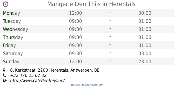
Mangerie Den Thijs
Kerkstraat 8, Herentals
Bar
read more
6.303 km
De Bierhoeve
Herentalsesteenweg 107, Lille
Bar
read more
6.713 km
't Cafeeke Pulderbos
Dorp 23, Zandhoven
Bar
read more
6.804 km
Jeu ANCIEN QG
Boskant 2242, Zandhoven
Bar
read more
7.225 km
HTC Ter Heyde
Lichtaartseweg 216, Herentals
Bar
read more
8.905 km
Tuinterras De Koi
Itegembaan 281a, Berlaar
Bar
read more
9.382 km
parking van de beemden
Vogelzangstraat, Nijlen
Bar
read more
10.502 km
The Club
Bersegembaan 11, Lille
Bar
read more
10.953 km
Bar / Bistro De Lindeloo - Zoersel
Dorp 103, Zoersel
Bar
read more
12.356 km
Supportersclub Penyablaugranadelabomba
Aarschotsebaan 2, Berlaar
Bar
read more
12.521 km
JK 't Hoekske
Singel 29, Lille
Bar
read more
13.362 km
Klein Zwitserland
Zoerselbaan 87, Malle
Bar
read more
13.925 km
Brasserie Gero
Aarschotsesteenweg 151, Lier
Bar
read more
14.258 km
DE BEUKENHAAG
Raymond Delbekestraat 229, Zoersel
Bar
read more
14.338 km
Sint-Gummarus
Felix Timmermansplein 2, Lier
Bar
read more
14.418 km
Café René
Zimmerplein 10, Lier
Bar
read more
14.672 km
Baobab Beach Club
De Merodedreef 189, Westerlo
Bar
read more
14.756 km
De Speek
Larumseweg 3, Geel
Bar
read more
14.841 km
Bubbels
Steynhoefsedreef 12, Schilde
Bar
read more
15.937 km
M A N G I A R E
Geelsebaan 27 A, Kasterlee
Bar
read more
📑
all categories
Accounting
Administrative area level 1
Administrative area level 2
Airport
Amusement park
Aquarium
Art gallery
Atm
Bakery
Bank
Bar
Beauty salon
Bicycle store
Book store
Bowling alley
Bus station
Cafe
Campground
Car dealer
Car rental
Car repair
Car wash
Casino
Cemetery
Church
City hall
Clothing store
Colloquial area
Convenience store
Country
Courthouse
Dentist
Department store
Doctor
Electrician
Electronics store
Embassy
Finance
Fire station
Florist
Food
Funeral home
Furniture store
Gas station
General contractor
Grocery or supermarket
Gym
Hair care
Hardware store
Health
Hindu Temple
Home goods store
Hospital
Insurance agency
Jewelry store
Laundry
Lawyer
Library
Light rail station
Liquor store
Local government office
Locality
Locksmith
Lodging
Meal delivery
Meal takeaway
Mosque
Movie rental
Movie theater
Moving company
Museum
Natural feature
Neighborhood
Night club
Painter
Park
Parking
Pet store
Pharmacy
Physiotherapist
Place of worship
Plumber
Point of interest
Police
Political
Post office
Premise
Real estate agency
Restaurant
Roofing contractor
Route
Rv park, camping
School
Shoe store
Shopping mall
Spa
Stadium
Storage
Store
Subpremise
Subway station
Supermarket
Synagogue
Taxi stand
Train station
Transit station
Travel agency
University
Veterinary care
Zoo
sublocality level 1
sublocality level 2
sublocality level 3
↑