Bar nearby Bar 't Kafaat
Belgium
Bar nearby Bar 't Kafaat
Bar 't Kafaat
11, Eikelstraat, 2500, Lier, Antwerpen, BE Belgique
contacts phone
:
+32 492 91 03 04
website:
www.facebook.com
Latitude:
51.1302229
, Longitude:
4.5694331
larger map & directions
read more
nearest Bar
37 m
The Claddagh Irish Pub
Lier, Eikelstraat 30, Lier
Bar
read more
106 m
Café René
Zimmerplein 10, Lier
Bar
read more
107 m
Sint-Gummarus
Felix Timmermansplein 2, Lier
Bar
read more
293 m
't Kruisken
Kardinaal Mercierplein 3, Lier
Bar
read more
533 m
De Plezante Hoek
Lisperstraat 125, Lier
Bar
read more
840 m
Café-bistro Het Looks
Ros Beiaardstraat 13, Lier
Bar
read more
1.066 km
Jiu-Jitsu Akademie Lier vzw
Antwerpsesteenweg 97, Lier
Bar
read more
1.669 km
't Oud Lier
Nazaretdreef 103, Lier
Bar
read more
1.904 km
Riverside Beach Bar
Rivierstraat 108, Lier
Bar
read more
2.527 km
Mangero
Aarschotsesteenweg 151, Lier
Bar
read more
2.527 km
Brasserie Gero
Aarschotsesteenweg 151, Lier
Bar
read more
2.623 km
emblem hagenbroekseweg 17
Haegenbroekseweg 17, Ranst
Bar
read more
2.95 km
Brood en bloemen
Liersesteenweg 78, Ranst
Bar
read more
3.915 km
Beach Bar Lier
Mechelsesteenweg 380, Lier
Bar
read more
5.595 km
Costa Duffla
G. van der Lindenlaan, Duffel
Bar
read more
5.71 km
parking van de beemden
Vogelzangstraat, Nijlen
Bar
read more
5.78 km
Sportpark Sneppenbos
Vremdesesteenweg 224, Boechout
Bar
read more
9.084 km
Supportersclub Penyablaugranadelabomba
Aarschotsebaan 2, Berlaar
Bar
read more
14.333 km
Kelly's Irish Pub
De Keyserlei 27, Antwerpen
Bar
read more
14.404 km
Wheel Drive In bvba
Korte Stuivenbergstraat 11, Antwerpen
Bar
read more
14.453 km
Patsy's Palace
Solvynsstraat, Antwerpen
Bar
read more
14.719 km
Cocktails 4 Singles
Meir 107, Antwerpen
Bar
read more
15.304 km
Deust XL
Mechelen
Bar
read more
15.636 km
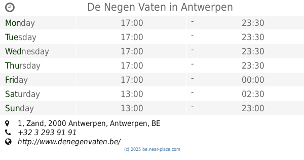
De Negen Vaten
Zand 1, Antwerpen
Bar
read more
15.777 km
De Konincklijke Snor
Adriaan Brouwerstraat 33, Antwerpen
Bar
read more
📑
all categories
Accounting
Administrative area level 1
Administrative area level 2
Airport
Amusement park
Aquarium
Art gallery
Atm
Bakery
Bank
Bar
Beauty salon
Bicycle store
Book store
Bowling alley
Bus station
Cafe
Campground
Car dealer
Car rental
Car repair
Car wash
Casino
Cemetery
Church
City hall
Clothing store
Colloquial area
Convenience store
Country
Courthouse
Dentist
Department store
Doctor
Electrician
Electronics store
Embassy
Finance
Fire station
Florist
Food
Funeral home
Furniture store
Gas station
General contractor
Grocery or supermarket
Gym
Hair care
Hardware store
Health
Hindu Temple
Home goods store
Hospital
Insurance agency
Jewelry store
Laundry
Lawyer
Library
Light rail station
Liquor store
Local government office
Locality
Locksmith
Lodging
Meal delivery
Meal takeaway
Mosque
Movie rental
Movie theater
Moving company
Museum
Natural feature
Neighborhood
Night club
Painter
Park
Parking
Pet store
Pharmacy
Physiotherapist
Place of worship
Plumber
Point of interest
Police
Political
Post office
Premise
Real estate agency
Restaurant
Roofing contractor
Route
Rv park, camping
School
Shoe store
Shopping mall
Spa
Stadium
Storage
Store
Subpremise
Subway station
Supermarket
Synagogue
Taxi stand
Train station
Transit station
Travel agency
University
Veterinary care
Zoo
sublocality level 1
sublocality level 2
sublocality level 3
↑