Bar nearby 1030 Café
Belgium
Bar nearby 1030 Café
1030 Café
Avenue Jan Stobbaerts 100, Schaerbeek Belgien
contacts phone
:
+32
Latitude:
50.8590957
, Longitude:
4.3892216
read more
nearest Bar
1030 Café
Jan Stobbaertslaan 100, Schaarbeek
Bar
read more
122 m
Chez Marraine
200, Avenue Chazal, Schaerbeek
Bar
read more
262 m
Duc du Brabant
Avenue Chazal 89, Schaerbeek
Bar
read more
511 m
Le Cordial
Avenue Rogier 336, Schaerbeek
Bar
read more
511 m
Le Cordial
Rogierlaan 336, Schaarbeek
Bar
read more
541 m
Wahis Club Resto-Bar
Boulevard Général Wahis 16B, Schaerbeek
Bar
read more
634 m
La Buvette Saint-Sébastien
Parc Josaphat 1030, Schaerbeek
Bar
read more
646 m
New Majestic Bar
Chaussée de Louvain 397, Bruxelles
Bar
read more
703 m
Marciana
Place Dailly 10, Schaerbeek
Bar
read more
818 m
Night club 360
Chaussée de Louvain 307, Schaerbeek
Bar
read more
874 m
wallace
Chaussée de Louvain, Schaerbeek
Bar
read more
874 m
wallace
Leuvensesteenweg, Schaarbeek
Bar
read more
994 m
Barrio BarrioLatino
Leuvensesteenweg 235, Sint-Joost-ten-Node
Bar
read more
994 m
Barrio BarrioLatino
Chaussée de Louvain 235, Saint-Josse-ten-Noode
Bar
read more
995 m
L'impair
Milcampslaan 86, Schaarbeek
Bar
read more
995 m
L'impair
Avenue Milcamps 86, Schaerbeek
Bar
read more
1.047 km
New Ecran
Chaussée de Louvain 215, Bruxelles
Bar
read more
1.077 km
Café du Parc
Rue des Moissons 61, Saint-Josse-ten-Noode
Bar
read more
1.088 km
New Plasky
Avenue Eugene Plasky 91, Schaerbeek
Bar
read more
1.097 km
Cafeparking Ismail
Place de Houffalize 4, Schaerbeek
Bar
read more
1.181 km
White Room Lounge
Chaussée de Louvain 240, Bruxelles
Bar
read more
1.342 km
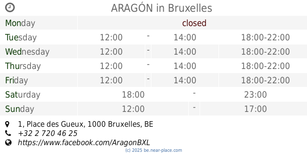
ARAGÓN
Place des Gueux 1, Bruxelles
Bar
read more
1.421 km
L'âne Fou
Koninklijke Sinte-Mariastraat 21, Schaarbeek
Bar
read more
1.713 km
Kitty’s
Boulevard Charlemagne 42, Bruxelles
Bar
read more
2.03 km
Bouddhas Berre Scris
Rue de l'Enseignement 92, Bruxelles
Bar
read more
📑
all categories
Accounting
Administrative area level 1
Administrative area level 2
Airport
Amusement park
Aquarium
Art gallery
Atm
Bakery
Bank
Bar
Beauty salon
Bicycle store
Book store
Bowling alley
Bus station
Cafe
Campground
Car dealer
Car rental
Car repair
Car wash
Casino
Cemetery
Church
City hall
Clothing store
Colloquial area
Convenience store
Country
Courthouse
Dentist
Department store
Doctor
Electrician
Electronics store
Embassy
Finance
Fire station
Florist
Food
Funeral home
Furniture store
Gas station
General contractor
Grocery or supermarket
Gym
Hair care
Hardware store
Health
Hindu Temple
Home goods store
Hospital
Insurance agency
Jewelry store
Laundry
Lawyer
Library
Light rail station
Liquor store
Local government office
Locality
Locksmith
Lodging
Meal delivery
Meal takeaway
Mosque
Movie rental
Movie theater
Moving company
Museum
Natural feature
Neighborhood
Night club
Painter
Park
Parking
Pet store
Pharmacy
Physiotherapist
Place of worship
Plumber
Point of interest
Police
Political
Post office
Premise
Real estate agency
Restaurant
Roofing contractor
Route
Rv park, camping
School
Shoe store
Shopping mall
Spa
Stadium
Storage
Store
Subpremise
Subway station
Supermarket
Synagogue
Taxi stand
Train station
Transit station
Travel agency
University
Veterinary care
Zoo
sublocality level 1
sublocality level 2
sublocality level 3
↑