Bakery nearby Rogge
Belgium
Bakery nearby Rogge
Rogge
Nieuwstraat 12, Kruishoutem Belgium
contacts phone
:
+32
Latitude:
50.9066438
, Longitude:
3.5288423
read more
nearest Bakery
245 m
Raes Bakkerij bvba
Winston Churchillstraat 19, Kruishoutem
Bakery
read more
312 m
bakkerij nadine
Hoogstraat 11, Kruishoutem
Bakery
read more
3.051 km
Bakkerij Martin
Lozerstraat 3, Kruishoutem
Bakery
read more
4.896 km
Rombaut / Marnix
Gaverstraat 15, Zingem
Bakery
read more
5.449 km
Bakkerij Boeckaert
Molenstraat 20, Zulte
Bakery
read more
6.97 km
Bracke / Guy
Putmanstraat 57, Waregem
Bakery
read more
7.139 km
Bakkerietje
Pand 203, Waregem
Bakery
read more
7.271 km
patisserie Vervaeck
Stormestraat 24, Waregem
Bakery
read more
7.528 km
't Baguetje Anzegem
Grote Leiestraat 72, Anzegem
Bakery
read more
7.554 km
Bakkerij Taerwe
Nestor de Tièrestraat 12, Oudenaarde
Bakery
read more
7.837 km
Bakkerij Aernoudt
Stationsstraat 41, Gavere
Bakery
read more
8.564 km
Janssens / Gerarda
Carlos Dierickxplein 2, Gavere
Bakery
read more
8.621 km
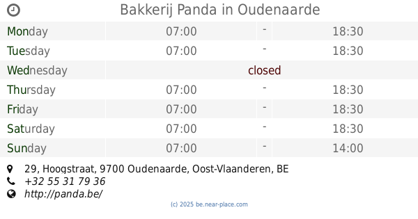
Bakkerij Panda
Hoogstraat 29, Oudenaarde
Bakery
read more
8.845 km
Bakkerij De Pourcq
Nieuwstraat 37, Deinze
Bakery
read more
9.572 km
Demeyer / Bart
Onderstraat 108, Gavere
Bakery
read more
9.727 km
Tack / Yvan
Wontergemstraat 51, Dentergem
Bakery
read more
9.738 km
Broodautomaat Bakkerij Wouter
Moerbosstraat 62, Waregem
Bakery
read more
11.224 km
Broodautomaat
Hoogstraat 19, Zwalm
Bakery
read more
12.905 km
Rutsaert / Bart
Baron de Gieylaan 20, De Pinte
Bakery
read more
17.093 km
Dellapan
Adolphe della Faillelaan 47, Gent
Bakery
read more
17.217 km
Thomaes / Yves
Otegemstraat 6, Zwevegem
Bakery
read more
19.296 km
Depredomme S.
Sportstraat 229, Gent
Bakery
read more
19.727 km
Bakkerij Aernoudt Kortrijksesteenweg
Kortrijksesteenweg 220, Gent
Bakery
read more
19.727 km
Bakery Aernoudt
Kortrijksesteenweg 220, Gent
Bakery
read more
19.893 km
Bakkerij Vandenbouhede / Wim
Ottergemsesteenweg 104, Gent
Bakery
read more
📑
all categories
Accounting
Administrative area level 1
Administrative area level 2
Airport
Amusement park
Aquarium
Art gallery
Atm
Bakery
Bank
Bar
Beauty salon
Bicycle store
Book store
Bowling alley
Bus station
Cafe
Campground
Car dealer
Car rental
Car repair
Car wash
Casino
Cemetery
Church
City hall
Clothing store
Colloquial area
Convenience store
Country
Courthouse
Dentist
Department store
Doctor
Electrician
Electronics store
Embassy
Finance
Fire station
Florist
Food
Funeral home
Furniture store
Gas station
General contractor
Grocery or supermarket
Gym
Hair care
Hardware store
Health
Hindu Temple
Home goods store
Hospital
Insurance agency
Jewelry store
Laundry
Lawyer
Library
Light rail station
Liquor store
Local government office
Locality
Locksmith
Lodging
Meal delivery
Meal takeaway
Mosque
Movie rental
Movie theater
Moving company
Museum
Natural feature
Neighborhood
Night club
Painter
Park
Parking
Pet store
Pharmacy
Physiotherapist
Place of worship
Plumber
Point of interest
Police
Political
Post office
Premise
Real estate agency
Restaurant
Roofing contractor
Route
Rv park, camping
School
Shoe store
Shopping mall
Spa
Stadium
Storage
Store
Subpremise
Subway station
Supermarket
Synagogue
Taxi stand
Train station
Transit station
Travel agency
University
Veterinary care
Zoo
sublocality level 1
sublocality level 2
sublocality level 3
↑