Bakery nearby Panerex
Belgium
Bakery nearby Panerex
Panerex
Sint-Servatiusstraat 94, Diepenbeek Belgium
contacts phone
:
+32
Latitude:
50.9308138
, Longitude:
5.434156
read more
nearest Bakery
1.251 km
BAKKERIJ MIK MAK
Lutselusplein 12, Diepenbeek
Bakery
read more
1.288 km
Bakkerij 't Pleintje
Patersplein 3/A, Diepenbeek
Bakery
read more
2.549 km
Sint-Antonius
Volksstraat 57, Diepenbeek
Bakery
read more
2.636 km
La Baguette
Kapelstraat 45, Diepenbeek
Bakery
read more
2.755 km
Eymael / Nico
Marktplein 3, Diepenbeek
Bakery
read more
3.026 km
Koelen
Varkensmarkt 70, Diepenbeek
Bakery
read more
3.114 km
Ds-place.be
Grensstraat 120
Bakery
read more
3.311 km
de supperette
Bokrijklaan, Genk
Bakery
read more
3.58 km
Bakkerij Deneubourg
Landwaartslaan 14, Genk
Bakery
read more
3.945 km
Bakkerij Tomassen
Landwaartslaan 57, Genk
Bakery
read more
3.996 km
Bakkerij De Molen
Appelveldstraat 1, Bilzen
Bakery
read more
4.084 km
Cakes&more
Bouquetstraat 62, Diepenbeek
Bakery
read more
4.84 km
Deliway Genk
Hasseltweg 12-14, Genk
Bakery
read more
4.846 km
Deliway Genk
Hasseltweg 12/14, Genk
Bakery
read more
5.004 km
Koek (en) brood
6 bus 2, Tennislaan, Genk
Bakery
read more
5.026 km
Bakkerij Dana
Rozenkranslaan 26, Genk
Bakery
read more
5.026 km
Fabiano / Domenico
Rozenkranslaan 26, Genk
Bakery
read more
5.238 km
Patisserie Erik Pauli
Sint-Gertrudisplein 26, Bilzen
Bakery
read more
5.521 km
Brood & Zoet Schrijvers
Spoorwegstraat 9, Genk
Bakery
read more
5.679 km
Brood & Zoet Schrijvers
Grotestraat 28, Genk
Bakery
read more
6.032 km
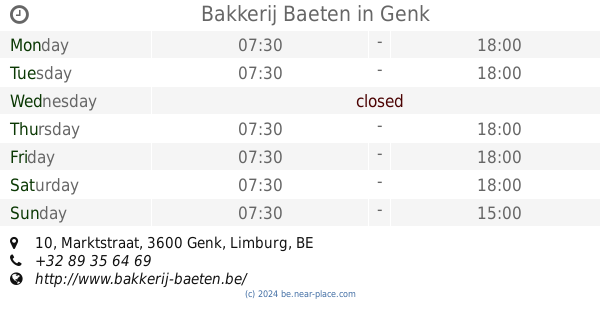
Bakkerij Baeten
Marktstraat 10, Genk
Bakery
read more
6.082 km
Geebelen
Stationsstraat 32, Genk
Bakery
read more
6.182 km
Dirix Banketbakker M.
Bochtlaan 1, Genk
Bakery
read more
6.27 km
Hypermarkt Carrefour GENK
Rootenstraat 8, Genk
Bakery
read more
6.27 km
hypermarkt Carrefour
Rootenstraat 8, Genk
Bakery
read more
📑
all categories
Accounting
Administrative area level 1
Administrative area level 2
Airport
Amusement park
Aquarium
Art gallery
Atm
Bakery
Bank
Bar
Beauty salon
Bicycle store
Book store
Bowling alley
Bus station
Cafe
Campground
Car dealer
Car rental
Car repair
Car wash
Casino
Cemetery
Church
City hall
Clothing store
Colloquial area
Convenience store
Country
Courthouse
Dentist
Department store
Doctor
Electrician
Electronics store
Embassy
Finance
Fire station
Florist
Food
Funeral home
Furniture store
Gas station
General contractor
Grocery or supermarket
Gym
Hair care
Hardware store
Health
Hindu Temple
Home goods store
Hospital
Insurance agency
Jewelry store
Laundry
Lawyer
Library
Light rail station
Liquor store
Local government office
Locality
Locksmith
Lodging
Meal delivery
Meal takeaway
Mosque
Movie rental
Movie theater
Moving company
Museum
Natural feature
Neighborhood
Night club
Painter
Park
Parking
Pet store
Pharmacy
Physiotherapist
Place of worship
Plumber
Point of interest
Police
Political
Post office
Premise
Real estate agency
Restaurant
Roofing contractor
Route
Rv park, camping
School
Shoe store
Shopping mall
Spa
Stadium
Storage
Store
Subpremise
Subway station
Supermarket
Synagogue
Taxi stand
Train station
Transit station
Travel agency
University
Veterinary care
Zoo
sublocality level 1
sublocality level 2
sublocality level 3
↑