Bakery nearby Deliway Ollignies
Belgium
Bakery nearby Deliway Ollignies
Deliway Ollignies
Chaussée Victor Lampe 186, Ollignies Belgien
contacts phone
:
+32
Latitude:
50.6725321
, Longitude:
3.8684211
read more
nearest Bakery
415 m
Vandemoortele Bakery Products
Rue des Artisans 47, Ath
Bakery
read more
1.324 km
Rasson / David
Chaussée de Grammont 47, Ath
Bakery
read more
1.736 km
L'artisanal
Chaussée de Grammont 47, Ath
Bakery
read more
1.824 km
Bakery François and Anne-Gaëlle
Rue des Combattants 69, Lessines
Bakery
read more
1.824 km
Boulangerie-Pâtisserie François et Anne-Gaëlle
Rue des Combattants 69, Lessines
Bakery
read more
2.795 km
Gourmandine
Rue d'Ollignies 9, Lessines
Bakery
read more
4.136 km
Chez Fabienne
Chaussée Gabrielle Richet 151, Lessines
Bakery
read more
4.538 km
Secci / Mario
Rue Eugène Dupont 57, Lessines
Bakery
read more
4.61 km
Le Comptoir Du Pain
Rue Cavée 26, Silly
Bakery
read more
5.092 km
La Halle sprl
Rue de la Halle 16, Lessines
Bakery
read more
5.121 km
Leurart / Claude
Rue de la Halle 8, Lessines
Bakery
read more
5.484 km
Poms'cannelle
Chaussée de Renaix 33, Lessines
Bakery
read more
9.538 km
Van Belle
Moerbekeplein 1, Geraardsbergen
Bakery
read more
11.009 km
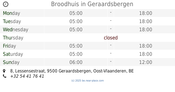
Broodhuis
Lessensestraat 8, Geraardsbergen
Bakery
read more
11.062 km
Declercq / Jan
Grotestraat 21, Geraardsbergen
Bakery
read more
11.371 km
Bakkerij De Vesten
Vesten 92, Geraardsbergen
Bakery
read more
11.403 km
Nevens / Pascal
Boelarestraat 38, Geraardsbergen
Bakery
read more
11.519 km
Bakkerij Van Belle
Marktplein 18, Galmaarden
Bakery
read more
11.601 km
Picalausa T.
Place 28, Flobecq
Bakery
read more
11.679 km
't Flieterhuisje
Ninoofsesteenweg 95, Galmaarden
Bakery
read more
12.356 km
Carrefour Express
Brusselstraat 24, Edingen
Bakery
read more
12.577 km
Deneyer / Peter
Geraardsbergsestraat 3, Lierde
Bakery
read more
13.515 km
Delabre Roland
Rue Planche 65, Flobecq
Bakery
read more
14.214 km
Dehaen-De Muylder / Christophe
Assesteenweg 51, Herne
Bakery
read more
15.93 km
Van Der Linden sprl
D'Hoppe 43, Vloesberg
Bakery
read more
📑
all categories
Accounting
Administrative area level 1
Administrative area level 2
Airport
Amusement park
Aquarium
Art gallery
Atm
Bakery
Bank
Bar
Beauty salon
Bicycle store
Book store
Bowling alley
Bus station
Cafe
Campground
Car dealer
Car rental
Car repair
Car wash
Casino
Cemetery
Church
City hall
Clothing store
Colloquial area
Convenience store
Country
Courthouse
Dentist
Department store
Doctor
Electrician
Electronics store
Embassy
Finance
Fire station
Florist
Food
Funeral home
Furniture store
Gas station
General contractor
Grocery or supermarket
Gym
Hair care
Hardware store
Health
Hindu Temple
Home goods store
Hospital
Insurance agency
Jewelry store
Laundry
Lawyer
Library
Light rail station
Liquor store
Local government office
Locality
Locksmith
Lodging
Meal delivery
Meal takeaway
Mosque
Movie rental
Movie theater
Moving company
Museum
Natural feature
Neighborhood
Night club
Painter
Park
Parking
Pet store
Pharmacy
Physiotherapist
Place of worship
Plumber
Point of interest
Police
Political
Post office
Premise
Real estate agency
Restaurant
Roofing contractor
Route
Rv park, camping
School
Shoe store
Shopping mall
Spa
Stadium
Storage
Store
Subpremise
Subway station
Supermarket
Synagogue
Taxi stand
Train station
Transit station
Travel agency
University
Veterinary care
Zoo
sublocality level 1
sublocality level 2
sublocality level 3
↑