Bakery nearby Boulangerie Brubel
Belgium
Bakery nearby Boulangerie Brubel
Boulangerie Brubel
Chaussée de Wavre 263, Bruxelles Belgien
contacts phone
:
+32
Latitude:
50.8357501
, Longitude:
4.3781909
read more
nearest Bakery
241 m
Allemeersch
Chaussée de Wavre 396, Etterbeek
Bakery
read more
241 m
Boulangerie Allemeersch
Chaussée de Wavre 396, Etterbeek
Bakery
read more
387 m
Carrefour Express Bruxelles
Place Raymond Blyckaerts 1-2, Bruxelles
Bakery
read more
404 m
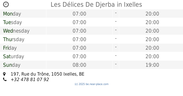
Les Délices De Djerba
Rue du Trône 197, Ixelles
Bakery
read more
524 m
Paul
Froissart straat 72, Etterbeek
Bakery
read more
524 m
PAUL
Rue Froissart 72, Etterbeek
Bakery
read more
597 m
Pain Loi sa
Luxemburgstraat 68, Brussel
Bakery
read more
616 m
Bagelstein
Luxemburgstraat 58, Brussel
Bakery
read more
617 m
Bagelstein
58, Luxemburgstraat, Brussel
Bakery
read more
641 m
Trifa
Rue Malibran 62, Ixelles
Bakery
read more
735 m
Petit PAUL
Metrostation Schuman, Rue de la Loi 175B, Brussel
Bakery
read more
815 m
Boulangerie et pattisserie malibran
Malibranstraat 22, Elsene
Bakery
read more
895 m
Boulangerie Dechaume
Vredestraat 32, Elsene
Bakery
read more
895 m
Boulangerie Dechaume
Rue de la Paix 32, Ixelles
Bakery
read more
919 m
Carrefour express
Elsensesteenweg 137, Brussel
Bakery
read more
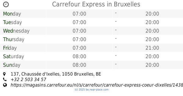
919 m
Carrefour Express
Chaussée d'Ixelles 137, Bruxelles
Bakery
read more
936 m
La Fleur du Pain
Eugène Flageyplein 24, Elsene
Bakery
read more
946 m
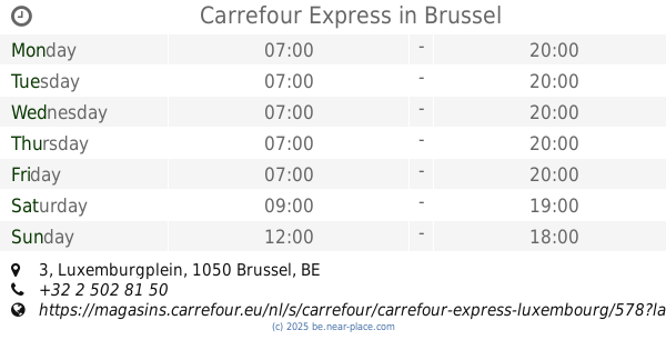
Carrefour Express
Luxemburgplein 3, Brussel
Bakery
read more
946 m
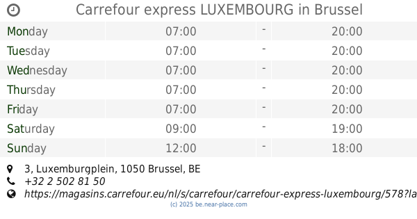
Carrefour express LUXEMBOURG
Luxemburgplein 3, Brussel
Bakery
read more
949 m
Gâteau
Rue des Boers 7, Etterbeek
Bakery
read more
949 m
Gâteau
Boerenstraat 7, Etterbeek
Bakery
read more
955 m
Bagl
Luxemburgstraat 1C, Brussel
Bakery
read more
978 m
PAUL
Rue du Luxembourg 2, Bruxelles
Bakery
read more
1.058 km
Boulanger pâtisserie Demaret
Avenue des Casernes 13, Etterbeek
Bakery
read more
1.058 km
Boulanger pâtisserie Demaret
Kazernenlaan 13, Etterbeek
Bakery
read more
📑
all categories
Accounting
Administrative area level 1
Administrative area level 2
Airport
Amusement park
Aquarium
Art gallery
Atm
Bakery
Bank
Bar
Beauty salon
Bicycle store
Book store
Bowling alley
Bus station
Cafe
Campground
Car dealer
Car rental
Car repair
Car wash
Casino
Cemetery
Church
City hall
Clothing store
Colloquial area
Convenience store
Country
Courthouse
Dentist
Department store
Doctor
Electrician
Electronics store
Embassy
Finance
Fire station
Florist
Food
Funeral home
Furniture store
Gas station
General contractor
Grocery or supermarket
Gym
Hair care
Hardware store
Health
Hindu Temple
Home goods store
Hospital
Insurance agency
Jewelry store
Laundry
Lawyer
Library
Light rail station
Liquor store
Local government office
Locality
Locksmith
Lodging
Meal delivery
Meal takeaway
Mosque
Movie rental
Movie theater
Moving company
Museum
Natural feature
Neighborhood
Night club
Painter
Park
Parking
Pet store
Pharmacy
Physiotherapist
Place of worship
Plumber
Point of interest
Police
Political
Post office
Premise
Real estate agency
Restaurant
Roofing contractor
Route
Rv park, camping
School
Shoe store
Shopping mall
Spa
Stadium
Storage
Store
Subpremise
Subway station
Supermarket
Synagogue
Taxi stand
Train station
Transit station
Travel agency
University
Veterinary care
Zoo
sublocality level 1
sublocality level 2
sublocality level 3
↑