Atm nearby ING
Belgium
Atm nearby ING
ING
94, Parklaan, 9100, Sint-Niklaas, Oost-Vlaanderen, BE België
contacts phone
:
+32
website:
www.ing.be
Latitude:
51.156729
, Longitude:
4.1541175
larger map & directions
read more
nearest Atm
692 m
ING
Kapelstraat 100, Sint-Niklaas
Atm
read more
1.358 km
Citibank, N.a.
Grote Markt 70, Sint-Niklaas
Atm
read more
1.763 km
ATM BNP Paribas Fortis Sint-Niklaas-NMBS Sint-Niklaas
Leopold II-laan 2, Sint-Niklaas
Atm
read more
2.735 km
AXA
Watermolenstraat 35a, Sint-Niklaas
Atm
read more
2.782 km
Axa
Watermolenstraat 19, BELSELE
Atm
read more
3.864 km
Axa
Veldstraat 387, Temse
Atm
read more
4.541 km
Belfius Bank
Vrasenestraat 12, NIEUWKERKEN-WAAS
Atm
read more
5.118 km
Record Bank
Antwerpse STWG 2
Atm
read more
5.493 km
Dexia
Markt 14, Temse
Atm
read more
6.679 km
BNP Paribas Fortis
Marktplein 9, Hamme
Atm
read more
9.63 km
ING
Dorpsstraat 24, Stekene
Atm
read more
10.507 km
Belfius Bank
Koningsplein 30, Moerzeke
Atm
read more
12.153 km
Belfius Bank
Dokter Haekstraat 56, Dendermonde
Atm
read more
12.601 km
Record Bank
Grootzand 39, Dendermonde
Atm
read more
12.697 km
Belfius Bank
Heilig Hartplein 4, Zele
Atm
read more
12.77 km
ING
Markt 25, Zele
Atm
read more
12.847 km
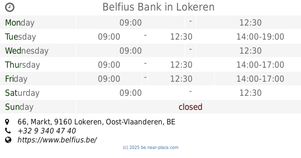
Belfius Bank
Markt 66, Lokeren
Atm
read more
13.624 km
Rabobank
Sint Jansteen
Atm
read more
13.834 km
Kioskplaats Hoboken Centrum
Kioskplaats 49, Hoboken (Antw.)
Atm
read more
13.845 km
ING België Nv
Dorp West 5, Zwijndrecht
Atm
read more
15.229 km
Rabobank
Nieuwstraat 120, Koewacht
Atm
read more
15.302 km
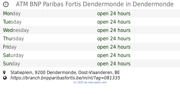
ATM BNP Paribas Fortis Dendermonde
Statieplein, Dendermonde
Atm
read more
15.988 km
AXA Bank
's Herenbaan 239, Boom
Atm
read more
17.993 km
Axa
Overwinningsstraat 34, Willebroek
Atm
read more
20.323 km
Axa
Hoogstraat 111, Tisselt
Atm
read more
📑
all categories
Accounting
Administrative area level 1
Administrative area level 2
Airport
Amusement park
Aquarium
Art gallery
Atm
Bakery
Bank
Bar
Beauty salon
Bicycle store
Book store
Bowling alley
Bus station
Cafe
Campground
Car dealer
Car rental
Car repair
Car wash
Casino
Cemetery
Church
City hall
Clothing store
Colloquial area
Convenience store
Country
Courthouse
Dentist
Department store
Doctor
Electrician
Electronics store
Embassy
Finance
Fire station
Florist
Food
Funeral home
Furniture store
Gas station
General contractor
Grocery or supermarket
Gym
Hair care
Hardware store
Health
Hindu Temple
Home goods store
Hospital
Insurance agency
Jewelry store
Laundry
Lawyer
Library
Light rail station
Liquor store
Local government office
Locality
Locksmith
Lodging
Meal delivery
Meal takeaway
Mosque
Movie rental
Movie theater
Moving company
Museum
Natural feature
Neighborhood
Night club
Painter
Park
Parking
Pet store
Pharmacy
Physiotherapist
Place of worship
Plumber
Point of interest
Police
Political
Post office
Premise
Real estate agency
Restaurant
Roofing contractor
Route
Rv park, camping
School
Shoe store
Shopping mall
Spa
Stadium
Storage
Store
Subpremise
Subway station
Supermarket
Synagogue
Taxi stand
Train station
Transit station
Travel agency
University
Veterinary care
Zoo
sublocality level 1
sublocality level 2
sublocality level 3
↑