Store nearby e-Clouds Erembodegem
Belgium
Store nearby e-Clouds Erembodegem
e-Clouds Erembodegem
Brusselbaan 95c, Aalst België
contacts phone
:
+32
Latitude:
50.9210764
, Longitude:
4.0699987
read more
nearest Store
303 m
Aalsters Hoorcentrum
Hogeweg 78, Aalst
Store
read more
353 m
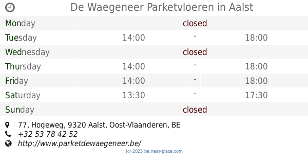
De Waegeneer Parketvloeren
Hogeweg 77, Aalst
Store
read more
367 m
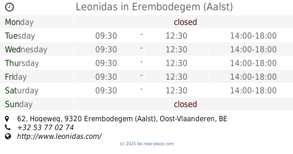
Leonidas
Hogeweg 62, Erembodegem (Aalst)
Store
read more
397 m
Caudron / Luc
Hogeweg 56, Aalst
Store
read more
449 m
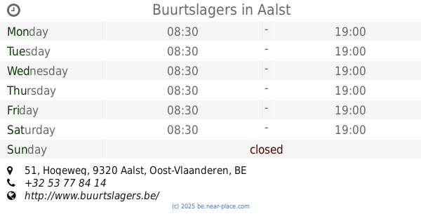
Buurtslagers
Hogeweg 51, Aalst
Store
read more
563 m
Optiek Passe-partout
Hogeweg 21, Aalst
Store
read more
667 m
Vandenberghen / Guy
Erembodegem-Dorp 72, Erembodegem (Aalst)
Store
read more
700 m
Fidoucia
Brusselse Steenweg 199, Aalst
Store
read more
764 m
De Maalsteen
Erembodegem-Dorp 80, Aalst
Store
read more
876 m
Ledegen / Magda
Dokter Carlierlaan 13, Erembodegem (Aalst)
Store
read more
884 m
Kruidvat
Dorp 46, Erembodegem
Store
read more
939 m
Luc & Marianne
Erembodegem-Dorp 89, Aalst
Store
read more
1.208 km
Verhertbruggen / Dominique
Letterveldweg 5, Erembodegem (Aalst)
Store
read more
1.241 km
De Schepper / Francois
Italiënweg 11, Aalst
Store
read more
1.241 km
Moens / Bart
Italiënweg 54, Erembodegem (Aalst)
Store
read more
1.927 km
Callebaut / Paul
Hulstbos 5, Affligem
Store
read more
1.945 km
Verleysen / Jan
Ninovesteenweg 154, Erembodegem (Aalst)
Store
read more
2.073 km
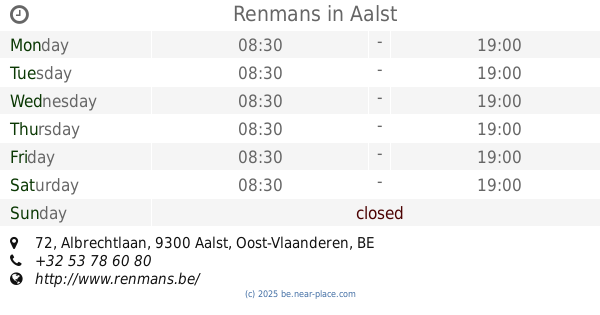
Renmans
Albrechtlaan 72, Aalst
Store
read more
2.089 km
Vishandel Geert
Brusselbaan 21, Affligem
Store
read more
2.105 km
Automotive Technical Service (ATS) nv
Industrielaan 33, Aalst
Store
read more
2.374 km
Vishandel Lavaert
Houtmarkt 3, Aalst
Store
read more
2.375 km
Samdam Retail
Houtmarkt 6, Aalst
Store
read more
2.581 km
Wibra nv
Pontstraat 26, Aalst
Store
read more
2.611 km
Cirk Tattoo
Pontstraat 19, Aalst
Store
read more
2.664 km
De Vijlder / D.
Pontstraat 14, Aalst
Store
read more
📑
all categories
Accounting
Administrative area level 1
Administrative area level 2
Airport
Amusement park
Aquarium
Art gallery
Atm
Bakery
Bank
Bar
Beauty salon
Bicycle store
Book store
Bowling alley
Bus station
Cafe
Campground
Car dealer
Car rental
Car repair
Car wash
Casino
Cemetery
Church
City hall
Clothing store
Colloquial area
Convenience store
Country
Courthouse
Dentist
Department store
Doctor
Electrician
Electronics store
Embassy
Finance
Fire station
Florist
Food
Funeral home
Furniture store
Gas station
General contractor
Grocery or supermarket
Gym
Hair care
Hardware store
Health
Hindu Temple
Home goods store
Hospital
Insurance agency
Jewelry store
Laundry
Lawyer
Library
Light rail station
Liquor store
Local government office
Locality
Locksmith
Lodging
Meal delivery
Meal takeaway
Mosque
Movie rental
Movie theater
Moving company
Museum
Natural feature
Neighborhood
Night club
Painter
Park
Parking
Pet store
Pharmacy
Physiotherapist
Place of worship
Plumber
Point of interest
Police
Political
Post office
Premise
Real estate agency
Restaurant
Roofing contractor
Route
Rv park, camping
School
Shoe store
Shopping mall
Spa
Stadium
Storage
Store
Subpremise
Subway station
Supermarket
Synagogue
Taxi stand
Train station
Transit station
Travel agency
University
Veterinary care
Zoo
sublocality level 1
sublocality level 2
sublocality level 3
↑