Store nearby Cartes Postales DEHAEN
Belgium
Store nearby Cartes Postales DEHAEN
Cartes Postales DEHAEN
Rue des Bouchers 70, Bruxelles Belgique
contacts phone
:
+32
Latitude:
50.8473946
, Longitude:
4.3559158
read more
nearest Store
165 m
Euro House
Rue de la Colline 6, Brussel
Store
read more
173 m
la Belgique Gourmande
Rue de la Colline 9, Bruxelles
Store
read more
187 m
Corné Port Royal Bruxelles centre
Rue de la Madeleine 9, Bruxelles
Store
read more
205 m
Maison Antoine
Grote Markt 26, Brussel
Store
read more
237 m
Step Up Shop
Grasmarkt Straat 30, Brussel
Store
read more
238 m
Waffle Express
Brussel
Store
read more
255 m
Patisserie Orientale
Grasmarkt Straat 19, Brussel
Store
read more
294 m
Green Time
Grasmarkt Straat 4, Brussel
Store
read more
294 m
Leonidas
Rue des Fripiers 15, Bruxelles
Store
read more
336 m
Belgian Quality
Karel Bulsstraat 20, Brussel
Store
read more
361 m
Hairdis Monnaie
Place de la Monnaie 15, Bruxelles
Store
read more
361 m
Hairdis Monnaie
Munt 15, Brussel
Store
read more
407 m
Aargh Tattoo Shop
Gerechtsplein, Brussel
Store
read more
476 m
Chocoholic
Rue de l'Etuve 36, Bruxelles
Store
read more
571 m
Paul and Friendz Tattoo Shop
Rue du Marché au Charbon 79, Brussel
Store
read more
621 m
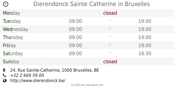
Dierendonck Sainte Catherine
Rue Sainte-Catherine 24, Bruxelles
Store
read more
656 m
GODIVA Sablon Store
Grote Zavel 47, Brussel
Store
read more
779 m
Claire Fontaine
Rue Ernest Allard 3, Bruxelles
Store
read more
785 m
Ciel mes bijoux Vintage
Rue Ernest Allard 5, Bruxelles
Store
read more
804 m
Flormar
Nieuwstraat 123, Brussel
Store
read more
921 m
Amadeus
Rue de Namur 65, Bruxelles
Store
read more
1.011 km
Wabis
Chaussée de Louvain 3, Saint-Josse-ten-Noode
Store
read more
1.021 km
Anna Garello SA
Kernstraat 54, Brussel
Store
read more
1.083 km
AMWAY BUSINESS
Maurice Lemonnierlaan 151, Brussel
Store
read more
1.195 km
Le Pacific
Avenue de Stalingrad 73, Bruxelles
Store
read more
📑
all categories
Accounting
Administrative area level 1
Administrative area level 2
Airport
Amusement park
Aquarium
Art gallery
Atm
Bakery
Bank
Bar
Beauty salon
Bicycle store
Book store
Bowling alley
Bus station
Cafe
Campground
Car dealer
Car rental
Car repair
Car wash
Casino
Cemetery
Church
City hall
Clothing store
Colloquial area
Convenience store
Country
Courthouse
Dentist
Department store
Doctor
Electrician
Electronics store
Embassy
Finance
Fire station
Florist
Food
Funeral home
Furniture store
Gas station
General contractor
Grocery or supermarket
Gym
Hair care
Hardware store
Health
Hindu Temple
Home goods store
Hospital
Insurance agency
Jewelry store
Laundry
Lawyer
Library
Light rail station
Liquor store
Local government office
Locality
Locksmith
Lodging
Meal delivery
Meal takeaway
Mosque
Movie rental
Movie theater
Moving company
Museum
Natural feature
Neighborhood
Night club
Painter
Park
Parking
Pet store
Pharmacy
Physiotherapist
Place of worship
Plumber
Point of interest
Police
Political
Post office
Premise
Real estate agency
Restaurant
Roofing contractor
Route
Rv park, camping
School
Shoe store
Shopping mall
Spa
Stadium
Storage
Store
Subpremise
Subway station
Supermarket
Synagogue
Taxi stand
Train station
Transit station
Travel agency
University
Veterinary care
Zoo
sublocality level 1
sublocality level 2
sublocality level 3
↑