Store nearby Apotheek PharmaClic Leuven
Coronavirus disease (COVID-19) Situation
confirmed cases
4861695
deaths
34376
Belgium
Store nearby Apotheek PharmaClic Leuven
Apotheek PharmaClic Leuven
Bondgenotenlaan 88, Leuven Belgium
contacts phone
:
+32
Latitude:
50.8803328
, Longitude:
4.7102896
read more
nearest Store
95 m
Kruidvat
Bondgenotenlaan 95, Leuven
Store
read more
137 m
"Ginseng" imp/exp
Diestsestraat 177, Leuven
Store
read more
260 m
Beenhouwerij Mediterranee
Maria Theresiastraat 45, Leuven
Store
read more
290 m
De Kringwinkel SPIT Leuven
Diestsestraat 253, Leuven
Store
read more
343 m
BASE shop Leuven - Bondgenotenlaan
Bondgenotenlaan 29, Leuven
Store
read more
359 m
Mac Store Leuven
Bondgenotenlaan 25, Leuven
Store
read more
375 m
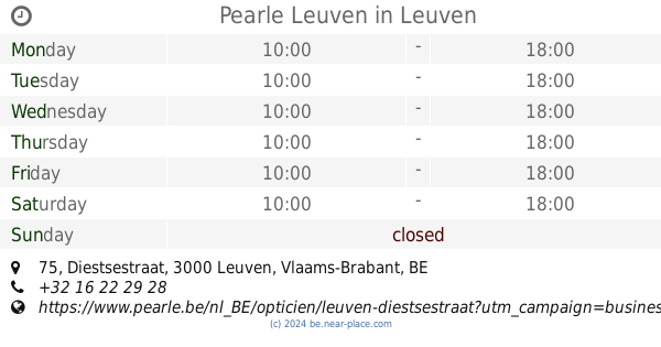
Pearle Leuven
Diestsestraat 75, Leuven
Store
read more
390 m
Think Chocolate!
Leopold Vanderkelenstraat 43, Leuven
Store
read more
393 m
De Theewinkel
Leopold Vanderkelenstraat 41, Leuven
Store
read more
418 m
De Wolf Opticiens
Leopold Vanderkelenstraat 25, Leuven
Store
read more
479 m
Brown Betty
Bondgenotenlaan 6, Leuven
Store
read more
516 m
Smatch
Ernest Solvaystraat 62, Leuven
Store
read more
528 m
The Body Shop
Diestsestraat 25, Leuven
Store
read more
571 m
Reekmans-Vink J bvba
Tiensestraat 157, Leuven
Store
read more
632 m
Optics Mertens bvba
Leuvensestraat 1, Leuven
Store
read more
670 m
SPEELGOED MERTENS
Diestsesteenweg 61, Leuven
Store
read more
725 m
't Galetje
Kortestraat 3000, Leuven
Store
read more
740 m
Beenhouwerij Rondou
Pensstraat 5, Leuven
Store
read more
748 m
Patisserie Zuut
Vismarkt 2, Leuven
Store
read more
777 m
Di Leuven
Brusselsestraat 22, Leuven
Store
read more
813 m
In The Forest
40, Brusselsestraat 38, Leuven
Store
read more
913 m
Colson / NickTuinarchitect
Tiensesteenweg 172
Store
read more
922 m
Boucherie-Vanzegbroeck Jacques
Gemeentestraat 8, Leuven
Store
read more
1.001 km
Cla Distribution bvba
Koningin Astridlaan 34, Leuven
Store
read more
1.145 km
Ganga Jamuna Mini Supermarkt
Tiensesteenweg 126, Leuven
Store
read more
📑
all categories
Accounting
Administrative area level 1
Administrative area level 2
Airport
Amusement park
Aquarium
Art gallery
Atm
Bakery
Bank
Bar
Beauty salon
Bicycle store
Book store
Bowling alley
Bus station
Cafe
Campground
Car dealer
Car rental
Car repair
Car wash
Casino
Cemetery
Church
City hall
Clothing store
Colloquial area
Convenience store
Country
Courthouse
Dentist
Department store
Doctor
Electrician
Electronics store
Embassy
Finance
Fire station
Florist
Food
Funeral home
Furniture store
Gas station
General contractor
Grocery or supermarket
Gym
Hair care
Hardware store
Health
Hindu Temple
Home goods store
Hospital
Insurance agency
Jewelry store
Laundry
Lawyer
Library
Light rail station
Liquor store
Local government office
Locality
Locksmith
Lodging
Meal delivery
Meal takeaway
Mosque
Movie rental
Movie theater
Moving company
Museum
Natural feature
Neighborhood
Night club
Painter
Park
Parking
Pet store
Pharmacy
Physiotherapist
Place of worship
Plumber
Point of interest
Police
Political
Post office
Premise
Real estate agency
Restaurant
Roofing contractor
Route
Rv park, camping
School
Shoe store
Shopping mall
Spa
Stadium
Storage
Store
Subpremise
Subway station
Supermarket
Synagogue
Taxi stand
Train station
Transit station
Travel agency
University
Veterinary care
Zoo
sublocality level 1
sublocality level 2
sublocality level 3
↑