Restaurant nearby T Stoopke
Belgium
Restaurant nearby T Stoopke
T Stoopke
Ketsersdreef, Anzegem België
contacts phone
:
+32
Latitude:
50.8325354
, Longitude:
3.4989214
read more
nearest Restaurant
685 m
Steen / L.
Gijzelbrechtegemstraat 57, Anzegem
Restaurant
read more
920 m
Café Renee
Statiestraat 67, Anzegem
Restaurant
read more
1.413 km
De Hooiopper
Boskant 21, Wortegem-Petegem
Restaurant
read more
1.427 km
Oud Gemeenthuis
Kerkstraat 2, Anzegem
Restaurant
read more
1.651 km
'T Gaperke
Kerkstraat 73, Anzegem
Restaurant
read more
1.87 km
De Smulhoek, Frituur&eethuis
Kerkstraat 115, Anzegem
Restaurant
read more
2.36 km
Bistro biboo
Heuntjesstraat 7, Anzegem
Restaurant
read more
2.361 km
Deleersnyder / Stijn
Heuntjesstraat 7, Anzegem
Restaurant
read more
2.388 km
Frituur 'T Bolleke
Vichtsesteenweg 1, Anzegem
Restaurant
read more
2.405 km
Frank Delmote
Waregemseweg 28, Wortegem-Petegem
Restaurant
read more
2.692 km
Plein25
Elsegemplein 25, Wortegem-Petegem
Restaurant
read more
2.917 km
Te Lande
Kapellestraat 58, Tiegem
Restaurant
read more
2.938 km
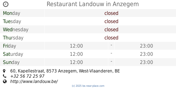
Restaurant Landouw
Kapellestraat 60, Anzegem
Restaurant
read more
2.938 km
Labie / Fiona
Kapellestraat 58, Anzegem
Restaurant
read more
2.983 km
Vossenhol
Tiegemberg 22, Anzegem
Restaurant
read more
3.03 km
TRKZK
Diepestraat 11, Wortegem-Petegem
Restaurant
read more
3.175 km
Moreelsgoed ('t)
Westdorp 17, Anzegem
Restaurant
read more
3.768 km
Den Brandewijn
Oudenaardseweg 88, Wortegem-Petegem
Restaurant
read more
4.322 km
Auberge L'Entrecote
Pontstraat 61, Kluisbergen
Restaurant
read more
4.871 km
Royal
Molenstraat 84, Kluisbergen
Restaurant
read more
5.045 km
Bistronoom
Waregemseweg 155, Wortegem-Petegem
Restaurant
read more
5.323 km
Cafe Restaurant De Fazant
Waregemseweg 159, Wortegem-Petegem
Restaurant
read more
5.53 km
Direct Express bvba
Kalkhoevestraat 1, Waregem
Restaurant
read more
5.642 km
Robuust
Wortegemseweg 115, Waregem
Restaurant
read more
6.787 km
STUT
Bieststraat 130a, Waregem
Restaurant
read more
📑
all categories
Accounting
Administrative area level 1
Administrative area level 2
Airport
Amusement park
Aquarium
Art gallery
Atm
Bakery
Bank
Bar
Beauty salon
Bicycle store
Book store
Bowling alley
Bus station
Cafe
Campground
Car dealer
Car rental
Car repair
Car wash
Casino
Cemetery
Church
City hall
Clothing store
Colloquial area
Convenience store
Country
Courthouse
Dentist
Department store
Doctor
Electrician
Electronics store
Embassy
Finance
Fire station
Florist
Food
Funeral home
Furniture store
Gas station
General contractor
Grocery or supermarket
Gym
Hair care
Hardware store
Health
Hindu Temple
Home goods store
Hospital
Insurance agency
Jewelry store
Laundry
Lawyer
Library
Light rail station
Liquor store
Local government office
Locality
Locksmith
Lodging
Meal delivery
Meal takeaway
Mosque
Movie rental
Movie theater
Moving company
Museum
Natural feature
Neighborhood
Night club
Painter
Park
Parking
Pet store
Pharmacy
Physiotherapist
Place of worship
Plumber
Point of interest
Police
Political
Post office
Premise
Real estate agency
Restaurant
Roofing contractor
Route
Rv park, camping
School
Shoe store
Shopping mall
Spa
Stadium
Storage
Store
Subpremise
Subway station
Supermarket
Synagogue
Taxi stand
Train station
Transit station
Travel agency
University
Veterinary care
Zoo
sublocality level 1
sublocality level 2
sublocality level 3
↑