Restaurant nearby 't Galerietje
Belgium
Restaurant nearby 't Galerietje
't Galerietje
Oudenaardsesteenweg 350, Avelgem België
contacts phone
:
+32
Latitude:
50.7903952
, Longitude:
3.4837463
read more
nearest Restaurant
525 m
Restaurant De Gouden Klokke
Trappelstraat 25, Avelgem
Restaurant
read more
595 m
Vancoppenolle / Thierry
Trappelstraat 25, Avelgem
Restaurant
read more
1.353 km
't Eenvoudig Bestaan
Krevelstraat 38, Kerkhove
Restaurant
read more
1.503 km
Frituur Snack 't Hoekske
Bruggesteenweg 1, Avelgem
Restaurant
read more
1.595 km
Royal
Molenstraat 84, Kluisbergen
Restaurant
read more
1.909 km
Jillies
Stationsstraat 41, Kluisbergen
Restaurant
read more
1.951 km
Frietlounge
Bloemenlaan 9, Kluisbergen
Restaurant
read more
2.091 km
Moreelsgoed ('t)
Westdorp 17, Anzegem
Restaurant
read more
2.18 km
Koevert
Krevelstraat 1, Kerkhove
Restaurant
read more
2.385 km
Auberge L'Entrecote
Pontstraat 61, Kluisbergen
Restaurant
read more
2.614 km
To Shing / Fu
Poletsestraat 18, Kluisbergen
Restaurant
read more
2.65 km
Frituur De Lekkerbek
Toekomststraat 2, Avelgem
Restaurant
read more
2.662 km
't Smeske
Okkerdries 2, Anzegem
Restaurant
read more
2.665 km
China Garden
Poletsestraat 18, Kluisbergen
Restaurant
read more
2.715 km
het verschil
Gentsestraat, Aalst
Restaurant
read more
2.82 km
Labie / Fiona
Kapellestraat 58, Anzegem
Restaurant
read more
2.82 km
Te Lande
Kapellestraat 58, Tiegem
Restaurant
read more
2.82 km
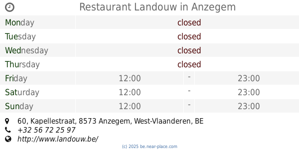
Restaurant Landouw
Kapellestraat 60, Anzegem
Restaurant
read more
2.949 km
Debacker / Maureen
Oudenaardsesteenweg 35, Avelgem
Restaurant
read more
3.052 km
't Monument
Ommegangstraat 11b, Kluisbergen
Restaurant
read more
3.134 km
Silva
Avelgem
Restaurant
read more
3.148 km
Retro Eetkaffee
Neerstraat 9, Avelgem
Restaurant
read more
3.286 km
In 't Palet
Kwaremontplein 25, Kluisbergen
Restaurant
read more
3.48 km
Pitta Melita
Doorniksesteenweg 104, Avelgem
Restaurant
read more
4.553 km
Bataille / André
Rue Monseigneur Descamps 24/B, Celles
Restaurant
read more
📑
all categories
Accounting
Administrative area level 1
Administrative area level 2
Airport
Amusement park
Aquarium
Art gallery
Atm
Bakery
Bank
Bar
Beauty salon
Bicycle store
Book store
Bowling alley
Bus station
Cafe
Campground
Car dealer
Car rental
Car repair
Car wash
Casino
Cemetery
Church
City hall
Clothing store
Colloquial area
Convenience store
Country
Courthouse
Dentist
Department store
Doctor
Electrician
Electronics store
Embassy
Finance
Fire station
Florist
Food
Funeral home
Furniture store
Gas station
General contractor
Grocery or supermarket
Gym
Hair care
Hardware store
Health
Hindu Temple
Home goods store
Hospital
Insurance agency
Jewelry store
Laundry
Lawyer
Library
Light rail station
Liquor store
Local government office
Locality
Locksmith
Lodging
Meal delivery
Meal takeaway
Mosque
Movie rental
Movie theater
Moving company
Museum
Natural feature
Neighborhood
Night club
Painter
Park
Parking
Pet store
Pharmacy
Physiotherapist
Place of worship
Plumber
Point of interest
Police
Political
Post office
Premise
Real estate agency
Restaurant
Roofing contractor
Route
Rv park, camping
School
Shoe store
Shopping mall
Spa
Stadium
Storage
Store
Subpremise
Subway station
Supermarket
Synagogue
Taxi stand
Train station
Transit station
Travel agency
University
Veterinary care
Zoo
sublocality level 1
sublocality level 2
sublocality level 3
↑