Restaurant nearby Ryckman M (Imperial)
Coronavirus disease (COVID-19) Situation
confirmed cases
4861695
deaths
34376
Belgium
Restaurant nearby Ryckman M (Imperial)
Ryckman M (Imperial)
Leopold I Esplanade 9//G 1, De Panne België
contacts phone
:
+32
Latitude:
51.0992875
, Longitude:
2.5798826
read more
nearest Restaurant
223 m
Leopold I Brasserie Restaurant
Pierre Bortierplein 20, De Panne
Restaurant
read more
248 m
Brasserie d'Esplanade
Leopold I Esplanade 2, De Panne
Restaurant
read more
401 m
Huyze Armalot
Ern. d'Arripelaan 13, De Panne
Restaurant
read more
594 m
Surf Inn
Zeedijk 31, De Panne
Restaurant
read more
747 m
IBIS KITCHEN LOUNGE
Zeelaan 2, De Panne
Restaurant
read more
763 m
Mirage
Zeedijk 9, De Panne
Restaurant
read more
822 m
De La Grand' Place
Zeelaan 69, De Panne
Restaurant
read more
831 m
Robinson
Zeelaan 169, De Panne
Restaurant
read more
854 m
Restro
Zeedijk 4, De Panne
Restaurant
read more
873 m
Pain Delice
Sloepenlaan 1, De Panne
Restaurant
read more
874 m
La Goulue
Nieuwpoortlaan 3, De Panne
Restaurant
read more
883 m
Albert I
Zeedijk 4, De Panne
Restaurant
read more
885 m
't Zeiltje
Markt 3, De Panne
Restaurant
read more
901 m
Resto-frituur ALBERTO
Nieuwpoortlaan 13, De Panne
Restaurant
read more
907 m
Pizzeria Italia Mia
Zeedijk 16, De Panne
Restaurant
read more
909 m
Bistro Der Alpen
Nieuwpoortlaan 15, De Panne
Restaurant
read more
918 m
Mc Arthur
Zeedijk 8-26, De Panne
Restaurant
read more
930 m
La Cabine
Sloepenlaan 12, De Panne
Restaurant
read more
966 m
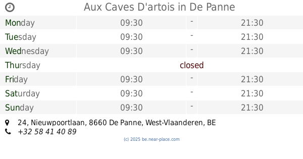
Aux Caves D'artois
Nieuwpoortlaan 24, De Panne
Restaurant
read more
973 m
pommefriet
Zeedijk 28-54, De Panne
Restaurant
read more
989 m
Steak House
Nieuwpoortlaan 30, De Panne
Restaurant
read more
1.031 km
La Carimali
Zeedijk 44, De Panne
Restaurant
read more
1.035 km
Kommilfoo De Panne
Veurnestraat 83, De Panne
Restaurant
read more
1.065 km
Piot / Marie-Christine
Nieuwpoortlaan 44, De Panne
Restaurant
read more
1.065 km
Pammier
Mijnstraat 1, De Panne
Restaurant
read more
📑
all categories
Accounting
Administrative area level 1
Administrative area level 2
Airport
Amusement park
Aquarium
Art gallery
Atm
Bakery
Bank
Bar
Beauty salon
Bicycle store
Book store
Bowling alley
Bus station
Cafe
Campground
Car dealer
Car rental
Car repair
Car wash
Casino
Cemetery
Church
City hall
Clothing store
Colloquial area
Convenience store
Country
Courthouse
Dentist
Department store
Doctor
Electrician
Electronics store
Embassy
Finance
Fire station
Florist
Food
Funeral home
Furniture store
Gas station
General contractor
Grocery or supermarket
Gym
Hair care
Hardware store
Health
Hindu Temple
Home goods store
Hospital
Insurance agency
Jewelry store
Laundry
Lawyer
Library
Light rail station
Liquor store
Local government office
Locality
Locksmith
Lodging
Meal delivery
Meal takeaway
Mosque
Movie rental
Movie theater
Moving company
Museum
Natural feature
Neighborhood
Night club
Painter
Park
Parking
Pet store
Pharmacy
Physiotherapist
Place of worship
Plumber
Point of interest
Police
Political
Post office
Premise
Real estate agency
Restaurant
Roofing contractor
Route
Rv park, camping
School
Shoe store
Shopping mall
Spa
Stadium
Storage
Store
Subpremise
Subway station
Supermarket
Synagogue
Taxi stand
Train station
Transit station
Travel agency
University
Veterinary care
Zoo
sublocality level 1
sublocality level 2
sublocality level 3
↑