Restaurant nearby Panos
Belgium
Restaurant nearby Panos
Panos
Rue Pisseroule 213, Dison Belgien
contacts phone
:
+32
Latitude:
50.6011457
, Longitude:
5.8527903
read more
nearest Restaurant
215 m
Mystic Pizza Da Renato
Rue de la Grappe 8, Dison
Restaurant
read more
510 m
Pizza Express Verviers
Rue de Dison 176, Verviers
Restaurant
read more
677 m
L'Usine
Rue Trauty, Dison
Restaurant
read more
790 m
Pita-Pizza chez Kekey
Rue Albert Ier, Dison
Restaurant
read more
881 m
Chez Youn's - Restaurant marocain
Rue Albert Ier 91, Dison
Restaurant
read more
971 m
Georges Brasserie
Place du Martyr 52, Verviers
Restaurant
read more
997 m
Ice Ben sprl
Place du Marché 8, Dison
Restaurant
read more
1000 m
Cucina
Pont Saint-Laurent 33, Verviers
Restaurant
read more
1.01 km
Devaux / Alain
Pont Saint-Laurent 31, Verviers
Restaurant
read more
1.025 km
Le Carré
Place du Martyr, Verviers
Restaurant
read more
1.05 km
Canadian Burgers
Place du Martyr 21, Verviers
Restaurant
read more
1.057 km
L'Ogre de Barbarie
Pont Saint-Laurent 5, Verviers
Restaurant
read more
1.057 km
Baby Dragon
Rue du Collège 88, Verviers
Restaurant
read more
1.067 km
Le comptoir du collège
Rue du Collège 88, Verviers
Restaurant
read more
1.077 km
Snack L'Orient
Rue du Collège 78, Verviers
Restaurant
read more
1.082 km
L'étoile
Rue du Collège 70, Verviers
Restaurant
read more
1.082 km
L'Étoile - Restaurant à Verviers
Rue du Collège 70, Verviers
Restaurant
read more
1.096 km
La Grignotière
Pont aux Lions 19, Verviers
Restaurant
read more
1.123 km
Prestige Döner & Kebap
Pont aux Lions 2-4, Verviers
Restaurant
read more
1.126 km
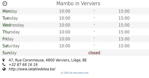
Mambo
Rue Coronmeuse 47, Verviers
Restaurant
read more
1.131 km
La sandwichomania
Place Verte, Verviers
Restaurant
read more
1.162 km
Cours D Asse
Rue Coronmeuse, Verviers
Restaurant
read more
1.2 km
Pita Döner Kebap (Pita Martyrs)
Rue des Martyrs 5, Verviers
Restaurant
read more
1.221 km
Binh Long
Rue Ortmans-Hauzeur 46, Verviers
Restaurant
read more
1.282 km
Chez Baba
Crapaurue 28, Verviers
Restaurant
read more
📑
all categories
Accounting
Administrative area level 1
Administrative area level 2
Airport
Amusement park
Aquarium
Art gallery
Atm
Bakery
Bank
Bar
Beauty salon
Bicycle store
Book store
Bowling alley
Bus station
Cafe
Campground
Car dealer
Car rental
Car repair
Car wash
Casino
Cemetery
Church
City hall
Clothing store
Colloquial area
Convenience store
Country
Courthouse
Dentist
Department store
Doctor
Electrician
Electronics store
Embassy
Finance
Fire station
Florist
Food
Funeral home
Furniture store
Gas station
General contractor
Grocery or supermarket
Gym
Hair care
Hardware store
Health
Hindu Temple
Home goods store
Hospital
Insurance agency
Jewelry store
Laundry
Lawyer
Library
Light rail station
Liquor store
Local government office
Locality
Locksmith
Lodging
Meal delivery
Meal takeaway
Mosque
Movie rental
Movie theater
Moving company
Museum
Natural feature
Neighborhood
Night club
Painter
Park
Parking
Pet store
Pharmacy
Physiotherapist
Place of worship
Plumber
Point of interest
Police
Political
Post office
Premise
Real estate agency
Restaurant
Roofing contractor
Route
Rv park, camping
School
Shoe store
Shopping mall
Spa
Stadium
Storage
Store
Subpremise
Subway station
Supermarket
Synagogue
Taxi stand
Train station
Transit station
Travel agency
University
Veterinary care
Zoo
sublocality level 1
sublocality level 2
sublocality level 3
↑