Restaurant nearby Panino
Belgium
Restaurant nearby Panino
Panino
Sint Jobstraat 276, Aalst Belgien
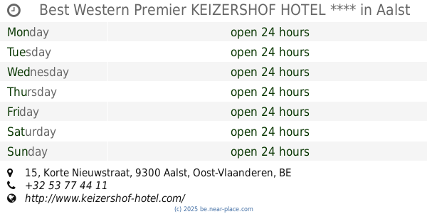
contacts phone
:
+32
Latitude:
50.9312113
, Longitude:
4.0264059
read more
nearest Restaurant
799 m
RESTAURANT CARTEL, het enige échte mosselrestaurant van Aalst!
Sinte Annalaan 2, Aalst
Restaurant
read more
838 m
Brasserie Blomme
Gentsesteenweg 100, Aalst
Restaurant
read more
908 m
Bistro D'licious
Gentsestraat 4, Aalst
Restaurant
read more
918 m
De Vesten
Keizersplein 10, Aalst
Restaurant
read more
922 m
Allegro Ma Non Troppo
Gentsestraat 16, Aalst
Restaurant
read more
924 m
Tang's Palace
Korte Zoutstraat 51, Aalst
Restaurant
read more
955 m
Best Western Premier KEIZERSHOF HOTEL ****
Korte Nieuwstraat 15, Aalst
Restaurant
read more
965 m
S Zoetje Hoekje
Korte Zoutstraat, Aalst
Restaurant
read more
979 m
KEBAB ZONE
4, Korte Nieuwstraat, Aalst
Restaurant
read more
985 m
Skanes Pita & Couscous
Hopmarkt, Aalst
Restaurant
read more
1.011 km
Popeye Snack
Korte Zoutstraat 36, Aalst
Restaurant
read more
1.019 km
Wilfried
Hopmarkt 23, Aalst
Restaurant
read more
1.02 km
La Table d'Hugo
De Ridderstraat 68, Aalst
Restaurant
read more
1.054 km
De Soeptrien
Sint Jorisstraat 11, Aalst
Restaurant
read more
1.055 km
Hop En GO RESTAURANT TAVERNE
Hopmarkt, Aalst
Restaurant
read more
1.059 km
De Kraanvogel
Hopmarkt 44, Aalst
Restaurant
read more
1.112 km
O'Bistro
Nieuwstraat 21, Aalst
Restaurant
read more
1.121 km
Sam's Story
Lange Zoutstraat 44, Aalst
Restaurant
read more
1.123 km
Yok Tha
Vrijheidstraat 38, Aalst
Restaurant
read more
1.144 km
McDonald's Aalst
Grote Markt 15, Aalst
Restaurant
read more
1.152 km
Markt 12
Grote Markt 14, Aalst
Restaurant
read more
1.176 km
Naxos
De Ridderstraat 7, Aalst
Restaurant
read more
1.198 km
De Zwarte Kat
Kerkstraat 1, Aalst
Restaurant
read more
1.207 km
Friends Aalst
Kattestraat, Aalst
Restaurant
read more
1.216 km
In 't Filetpurken
Kerkstraat 9, Aalst
Restaurant
read more
📑
all categories
Accounting
Administrative area level 1
Administrative area level 2
Airport
Amusement park
Aquarium
Art gallery
Atm
Bakery
Bank
Bar
Beauty salon
Bicycle store
Book store
Bowling alley
Bus station
Cafe
Campground
Car dealer
Car rental
Car repair
Car wash
Casino
Cemetery
Church
City hall
Clothing store
Colloquial area
Convenience store
Country
Courthouse
Dentist
Department store
Doctor
Electrician
Electronics store
Embassy
Finance
Fire station
Florist
Food
Funeral home
Furniture store
Gas station
General contractor
Grocery or supermarket
Gym
Hair care
Hardware store
Health
Hindu Temple
Home goods store
Hospital
Insurance agency
Jewelry store
Laundry
Lawyer
Library
Light rail station
Liquor store
Local government office
Locality
Locksmith
Lodging
Meal delivery
Meal takeaway
Mosque
Movie rental
Movie theater
Moving company
Museum
Natural feature
Neighborhood
Night club
Painter
Park
Parking
Pet store
Pharmacy
Physiotherapist
Place of worship
Plumber
Point of interest
Police
Political
Post office
Premise
Real estate agency
Restaurant
Roofing contractor
Route
Rv park, camping
School
Shoe store
Shopping mall
Spa
Stadium
Storage
Store
Subpremise
Subway station
Supermarket
Synagogue
Taxi stand
Train station
Transit station
Travel agency
University
Veterinary care
Zoo
sublocality level 1
sublocality level 2
sublocality level 3
↑