Restaurant nearby EAT WELL
Belgium
Restaurant nearby EAT WELL
EAT WELL
Galerie Ravenstein 22 Belgien
contacts phone
:
+32
Latitude:
50.8450035
, Longitude:
4.3581177
read more
nearest Restaurant
141 m
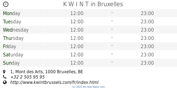
K W I N T
Mont des Arts 1, Bruxelles
Restaurant
read more
246 m
La Charrette Gourmande - BSF
Koudenberg 1, Brussel
Restaurant
read more
442 m
La Petite Maison
Belgium, Beenhouwersstraat 19, Brussel
Restaurant
read more
508 m
C'est bon C'est belge
Rollebeekstraat 3, Brussel
Restaurant
read more
517 m
Genco
Rue Joseph Stevens 28, Bruxelles
Restaurant
read more
520 m
ビストレ.オリジナ
Joseph Stevensstraat 24, Brussel
Restaurant
read more
534 m
Il Passatempo
Naamsestraat 32, Brussel
Restaurant
read more
573 m
Per Bacco Pizzeria
Rue de l'Enseignement 31, Bruxelles
Restaurant
read more
615 m
Snack Tonic
Rue de l'Etuve 67, Bruxelles
Restaurant
read more
680 m
Fantastico
Rue de l'Enseignement 71, Bruxelles
Restaurant
read more
731 m
Chao Chow City
Anspachlaan 89-91, Brussel
Restaurant
read more
733 m
La Cantina Brasil
Olivetenhof 15, Brussel
Restaurant
read more
747 m
McDonald's
Place de la Bourse 3, Bruxelles
Restaurant
read more
818 m
Sandwicherie
5, Noordstraat, Brussel
Restaurant
read more
831 m
Thai coffee
Congresstraat 50, Brussel
Restaurant
read more
849 m
Little Asia
Rue Sainte-Catherine 8, Bruxelles
Restaurant
read more
870 m
Snack Industrie
Rue de l'Industrie 26, Bruxelles
Restaurant
read more
898 m
NB Sandwichs
Rue de l'Industrie 9/A, Bruxelles
Restaurant
read more
1.021 km
Amor Amor
Rue du Trône 59, Ixelles
Restaurant
read more
1.043 km
Tamtam Gourmand
Chaussée de Wavre 72, Ixelles
Restaurant
read more
1.052 km
B34 Steak & Burger House
Rue Saint-Boniface 34, Ixelles
Restaurant
read more
1.131 km
Poivre et Sel
Parnassusstraat 2, Elsene
Restaurant
read more
1.151 km
Wiel's Renard Noir
Rue Haute 233, Bruxelles
Restaurant
read more
1.181 km
SIGNORA AVA
Vlaamsesteenweg 92, Brussel
Restaurant
read more
1.212 km
La Boule Bleue
Waversesteenweg 115, Brussel
Restaurant
read more
📑
all categories
Accounting
Administrative area level 1
Administrative area level 2
Airport
Amusement park
Aquarium
Art gallery
Atm
Bakery
Bank
Bar
Beauty salon
Bicycle store
Book store
Bowling alley
Bus station
Cafe
Campground
Car dealer
Car rental
Car repair
Car wash
Casino
Cemetery
Church
City hall
Clothing store
Colloquial area
Convenience store
Country
Courthouse
Dentist
Department store
Doctor
Electrician
Electronics store
Embassy
Finance
Fire station
Florist
Food
Funeral home
Furniture store
Gas station
General contractor
Grocery or supermarket
Gym
Hair care
Hardware store
Health
Hindu Temple
Home goods store
Hospital
Insurance agency
Jewelry store
Laundry
Lawyer
Library
Light rail station
Liquor store
Local government office
Locality
Locksmith
Lodging
Meal delivery
Meal takeaway
Mosque
Movie rental
Movie theater
Moving company
Museum
Natural feature
Neighborhood
Night club
Painter
Park
Parking
Pet store
Pharmacy
Physiotherapist
Place of worship
Plumber
Point of interest
Police
Political
Post office
Premise
Real estate agency
Restaurant
Roofing contractor
Route
Rv park, camping
School
Shoe store
Shopping mall
Spa
Stadium
Storage
Store
Subpremise
Subway station
Supermarket
Synagogue
Taxi stand
Train station
Transit station
Travel agency
University
Veterinary care
Zoo
sublocality level 1
sublocality level 2
sublocality level 3
↑