Restaurant nearby De Karper
Coronavirus disease (COVID-19) Situation
confirmed cases
4861695
deaths
34376
Belgium
Restaurant nearby De Karper
De Karper
Karperstraat, Zulte Belgia
contacts phone
:
+32
Latitude:
50.9587965
, Longitude:
3.4845063
read more
nearest Restaurant
43 m
Restaurant De Karper
Karperstraat 16, Machelen-aan-de-Leie
Restaurant
read more
125 m
De Afspanning
Machelendorp 4, Zulte
Restaurant
read more
142 m
De Afspanning
Machelendorp 4, Machelen-aan-de-Leie
Restaurant
read more
836 m
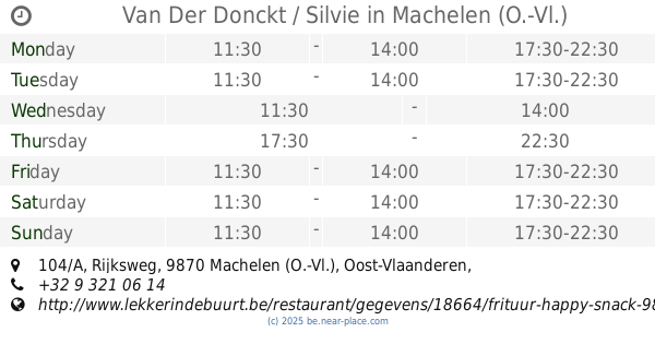
Van Der Donckt / Silvie
Rijksweg 104/A, Machelen (O.-Vl.)
Restaurant
read more
850 m
Frituur Happy Snack
Rijksweg 104, Machelen-aan-de-Leie
Restaurant
read more
1.191 km
Achtergaele / Yves
Rijksweg 32, Machelen-aan-de-Leie
Restaurant
read more
1.199 km
De Koornbloem
Rijksweg 32, Zulte
Restaurant
read more
1.491 km
Restaurant Napoleon
Rijksweg 160, Machelen
Restaurant
read more
1.763 km
Belegde Broodjesbar Tamajul
Grote Steenweg 22 A
Restaurant
read more
1.998 km
Lisabeth / Céline
Oude Heirbaan 72, Deinze
Restaurant
read more
2.182 km
De Zwaan
Oude Heirbaan 56, Deinze
Restaurant
read more
3.463 km
Piccolo Broodjeszaak
B1 58, Kortrijksesteenweg, Deinze
Restaurant
read more
3.595 km
't Friethuisje
Tweebruggenlaan, Deinze
Restaurant
read more
3.62 km
Di Trevi Deinze
Kortrijkstraat 86/1, Deinze
Restaurant
read more
3.895 km
Caprice (Tea-Room)
Kortrijkstraat 14, Deinze
Restaurant
read more
4.043 km
Bruschetta Mia
Markt 16, Deinze
Restaurant
read more
4.069 km
Palace Taverne
Markt 32, Deinze
Restaurant
read more
4.08 km
't Stoofpotje II
Markt 40, Deinze
Restaurant
read more
4.083 km
Het Genoegen
Markt 9, Deinze
Restaurant
read more
4.083 km
De Waele / Patricia
Markt 9, Deinze
Restaurant
read more
4.087 km
Stoofpotje deinze
Markt 40, Deinze
Restaurant
read more
4.089 km
Hedera
Markt 46, Bus 1, Deinze
Restaurant
read more
4.145 km
Broodjes&Pastazaak AVOCADO
Gentpoortstraat 4, Deinze
Restaurant
read more
4.158 km
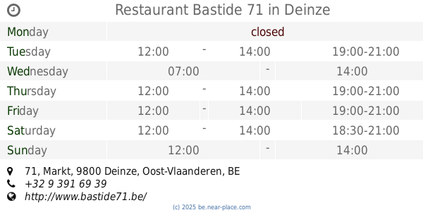
Restaurant Bastide 71
Markt 71, Deinze
Restaurant
read more
5.403 km
Frituur Joke
Deinsesteenweg 193, Tielt
Restaurant
read more
📑
all categories
Accounting
Administrative area level 1
Administrative area level 2
Airport
Amusement park
Aquarium
Art gallery
Atm
Bakery
Bank
Bar
Beauty salon
Bicycle store
Book store
Bowling alley
Bus station
Cafe
Campground
Car dealer
Car rental
Car repair
Car wash
Casino
Cemetery
Church
City hall
Clothing store
Colloquial area
Convenience store
Country
Courthouse
Dentist
Department store
Doctor
Electrician
Electronics store
Embassy
Finance
Fire station
Florist
Food
Funeral home
Furniture store
Gas station
General contractor
Grocery or supermarket
Gym
Hair care
Hardware store
Health
Hindu Temple
Home goods store
Hospital
Insurance agency
Jewelry store
Laundry
Lawyer
Library
Light rail station
Liquor store
Local government office
Locality
Locksmith
Lodging
Meal delivery
Meal takeaway
Mosque
Movie rental
Movie theater
Moving company
Museum
Natural feature
Neighborhood
Night club
Painter
Park
Parking
Pet store
Pharmacy
Physiotherapist
Place of worship
Plumber
Point of interest
Police
Political
Post office
Premise
Real estate agency
Restaurant
Roofing contractor
Route
Rv park, camping
School
Shoe store
Shopping mall
Spa
Stadium
Storage
Store
Subpremise
Subway station
Supermarket
Synagogue
Taxi stand
Train station
Transit station
Travel agency
University
Veterinary care
Zoo
sublocality level 1
sublocality level 2
sublocality level 3
↑