Restaurant nearby Carol's
Belgium
Restaurant nearby Carol's
Carol's
Seestraße 49, Bütgenbach Belgien
contacts phone
:
+32
Latitude:
50.4270833
, Longitude:
6.2124212
read more
nearest Restaurant
377 m
Casa Bella Italia
Seestraße 11, Bütgenbach
Restaurant
read more
383 m
Hong Kong
Seestraße 15/A, Bütgenbach
Restaurant
read more
501 m
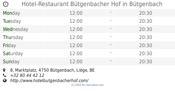
Hotel-Restaurant Bütgenbacher Hof
Marktplatz 8, Bütgenbach
Restaurant
read more
603 m
Nikolaus Grill
Marktplatz, Bütgenbach
Restaurant
read more
674 m
Brüls
Monschauer Straße 6, Bütgenbach
Restaurant
read more
1.014 km
Burgterassen
Berg,An der Lei 1, Bütgenbach
Restaurant
read more
1.217 km
Landhouse Küpper
Bütgenbach
Restaurant
read more
1.86 km
Snackeria
Zur Domäne 37, Bütgenbach
Restaurant
read more
1.939 km
Bacco
Nidrum,Warchestraße 17, Bütgenbach
Restaurant
read more
3.175 km
Ravel Number One
Bahnhofstraße 83, Bütgenbach
Restaurant
read more
3.188 km
Ravel Number One
Bahnhofstraße 83, Buetgenbach
Restaurant
read more
3.405 km
Robin Hood
Elsenborn,Trierer Straße 1, Bütgenbach
Restaurant
read more
3.518 km
Pitter's
Lagerstraße 8, Bütgenbach
Restaurant
read more
3.904 km
Pita Firat
Brückberg 5, Büllingen
Restaurant
read more
3.93 km
Snack-In
Brückberg 18, Büllingen
Restaurant
read more
3.93 km
Peters / Daniela
Brückberg 18, Büllingen
Restaurant
read more
3.962 km
Griesdeck
Griesdeck 60, Bütgenbach
Restaurant
read more
4.135 km
Lo Stivale
Hauptstraße 64, Büllingen
Restaurant
read more
5.815 km
Friterie WELKOM
84, Hinter der Heck, Bütgenbach
Restaurant
read more
7.002 km
Auberge du Lac
Rue du Lac 24, Waimes
Restaurant
read more
7.166 km
Piront Laurent
Rue d'Eupen 6, Waimes
Restaurant
read more
7.257 km
Le 49/50 brasserie restaurant
21, Rue du Centre, Waimes
Restaurant
read more
9.376 km
Le petit Mont Rigi
Route de Botrange 105, Waimes
Restaurant
read more
12.861 km
Soirée à Carthage
Rue du Commerce 24, Malmedy
Restaurant
read more
13.295 km
Danny's Snack
Gewerbezone Kaiserbaracke 62, Amel
Restaurant
read more
📑
all categories
Accounting
Administrative area level 1
Administrative area level 2
Airport
Amusement park
Aquarium
Art gallery
Atm
Bakery
Bank
Bar
Beauty salon
Bicycle store
Book store
Bowling alley
Bus station
Cafe
Campground
Car dealer
Car rental
Car repair
Car wash
Casino
Cemetery
Church
City hall
Clothing store
Colloquial area
Convenience store
Country
Courthouse
Dentist
Department store
Doctor
Electrician
Electronics store
Embassy
Finance
Fire station
Florist
Food
Funeral home
Furniture store
Gas station
General contractor
Grocery or supermarket
Gym
Hair care
Hardware store
Health
Hindu Temple
Home goods store
Hospital
Insurance agency
Jewelry store
Laundry
Lawyer
Library
Light rail station
Liquor store
Local government office
Locality
Locksmith
Lodging
Meal delivery
Meal takeaway
Mosque
Movie rental
Movie theater
Moving company
Museum
Natural feature
Neighborhood
Night club
Painter
Park
Parking
Pet store
Pharmacy
Physiotherapist
Place of worship
Plumber
Point of interest
Police
Political
Post office
Premise
Real estate agency
Restaurant
Roofing contractor
Route
Rv park, camping
School
Shoe store
Shopping mall
Spa
Stadium
Storage
Store
Subpremise
Subway station
Supermarket
Synagogue
Taxi stand
Train station
Transit station
Travel agency
University
Veterinary care
Zoo
sublocality level 1
sublocality level 2
sublocality level 3
↑