Restaurant nearby Bouffe! Kebab
Belgium
Restaurant nearby Bouffe! Kebab
Bouffe! Kebab
Kasteeldreef 96, Lovendegem België
contacts phone
:
+32
Latitude:
51.095739
, Longitude:
3.608278
read more
nearest Restaurant
80 m
Fou du Goût
Kasteeldreef 63, Lovendegem
Restaurant
read more
108 m
Kokopelli
Kasteeldreef, Lovendegem
Restaurant
read more
377 m
't Lanterfanterken
Kasteeldreef 27, Lovendegem
Restaurant
read more
384 m
De Baronie
Vaartstraat 36, Lovendegem
Restaurant
read more
1.302 km
De Oude Kale
Vijverstraat 43, Lovendegem
Restaurant
read more
1.944 km
De Flandrien
Oostveld Kouter 141, Lovendegem
Restaurant
read more
2.076 km
Cilurzo / Salvatore
Grote Baan 72, Lovendegem
Restaurant
read more
2.109 km
Brasserie Louloudi
Grote Baan 70, Lovendegem
Restaurant
read more
2.555 km
Il Padrino
Koning Leopoldstraat 86, Lovendegem
Restaurant
read more
2.611 km
Restaurant Vredesdreef3
Vredesdreef 3, Lovendegem
Restaurant
read more
2.673 km
't Aards Paradijs
Merendreedorp 65, Nevele
Restaurant
read more
2.702 km
Lootens / Lieven
Merendreedorp 65, Nevele
Restaurant
read more
2.895 km
Bistro Julien
Grote Baan 6, Lovendegem
Restaurant
read more
2.921 km
Gallez Valesca
Veldestraat 75, Nevele
Restaurant
read more
2.949 km
The Barn
Veldestraat 75, Nevele
Restaurant
read more
3.106 km
De Lieve's Bistronoom
Rabotstraat 120, Evergem
Restaurant
read more
3.248 km
Elia
Brugse Steenweg 9, Evergem
Restaurant
read more
3.257 km
Olive
Brugse Steenweg 9, Evergem
Restaurant
read more
4.216 km
Het Burgerhuis
Markt 20, Zomergem
Restaurant
read more
4.46 km
Greek Time
Brugsevaart 141
Restaurant
read more
5.002 km
Martens / Luc
Brouwerijstraat 2, Nevele
Restaurant
read more
5.01 km
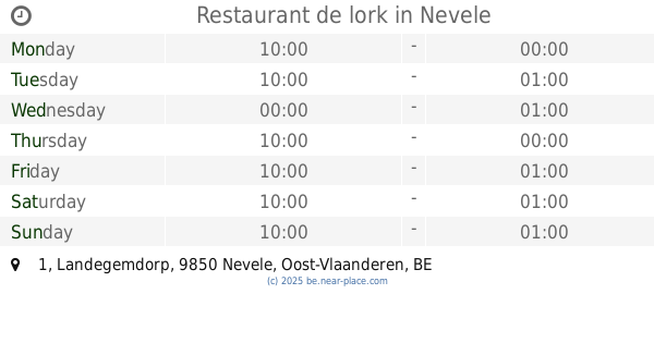
Restaurant de lork
11, Landegemdorp 1, Nevele
Restaurant
read more
5.133 km
Kip&gO
Eggenbos 11, Nevele
Restaurant
read more
6.101 km
Pizzahof
Adriaan Walckiersdreef 1, Drongen
Restaurant
read more
6.221 km
Hasan Baba
Vierkkensstraat, Vierhekkensstraat 25, Gent
Restaurant
read more
📑
all categories
Accounting
Administrative area level 1
Administrative area level 2
Airport
Amusement park
Aquarium
Art gallery
Atm
Bakery
Bank
Bar
Beauty salon
Bicycle store
Book store
Bowling alley
Bus station
Cafe
Campground
Car dealer
Car rental
Car repair
Car wash
Casino
Cemetery
Church
City hall
Clothing store
Colloquial area
Convenience store
Country
Courthouse
Dentist
Department store
Doctor
Electrician
Electronics store
Embassy
Finance
Fire station
Florist
Food
Funeral home
Furniture store
Gas station
General contractor
Grocery or supermarket
Gym
Hair care
Hardware store
Health
Hindu Temple
Home goods store
Hospital
Insurance agency
Jewelry store
Laundry
Lawyer
Library
Light rail station
Liquor store
Local government office
Locality
Locksmith
Lodging
Meal delivery
Meal takeaway
Mosque
Movie rental
Movie theater
Moving company
Museum
Natural feature
Neighborhood
Night club
Painter
Park
Parking
Pet store
Pharmacy
Physiotherapist
Place of worship
Plumber
Point of interest
Police
Political
Post office
Premise
Real estate agency
Restaurant
Roofing contractor
Route
Rv park, camping
School
Shoe store
Shopping mall
Spa
Stadium
Storage
Store
Subpremise
Subway station
Supermarket
Synagogue
Taxi stand
Train station
Transit station
Travel agency
University
Veterinary care
Zoo
sublocality level 1
sublocality level 2
sublocality level 3
↑