Restaurant nearby Blinis
Coronavirus disease (COVID-19) Situation
confirmed cases
4861695
deaths
34376
Belgium
Restaurant nearby Blinis
Blinis
Grote Markt 18a, Herentals België
contacts phone
:
+32
Latitude:
51.1766189
, Longitude:
4.8365226
read more
nearest Restaurant
21 m
Van Dyck / Liesbet
Grote Markt 18, Herentals
Restaurant
read more
51 m
Rosario Herentals
Grote Markt 13, Herentals
Restaurant
read more
54 m
De Noen
Hofkwartier 2, Herentals
Restaurant
read more
108 m
Brasserie Den Engel
Kerkstraat 1, Herentals
Restaurant
read more
112 m
Pasta Tin
Zandstraat 5, Herentals
Restaurant
read more
129 m
Eglantier
Bovenrij 75, Herentals
Restaurant
read more
133 m
Christel's Croissy Express
Zandstraat 16, Herentals
Restaurant
read more
143 m
Panos
Zandstraat 15, Herentals
Restaurant
read more
151 m
Brasserie de Noen
Belgium, Hofkwartier 2, Herentals
Restaurant
read more
168 m
Nikkosushi
Zandstraat 28, Herentals
Restaurant
read more
226 m
Den Entree
Collegestraat 1, Herentals
Restaurant
read more
232 m
Chinees Restaurant Tai-Ton
Bovenrij 41, Herentals
Restaurant
read more
238 m
Paco-snack
Zandstraat 28, Herentals
Restaurant
read more
370 m
Tasse Tout
Zandstraat 90, Herentals
Restaurant
read more
382 m
De Fluitketel
Zandstraat 83, Herentals
Restaurant
read more
409 m
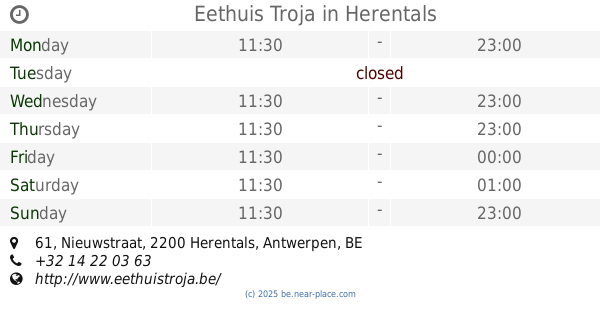
Eethuis Troja
Nieuwstraat 61, Herentals
Restaurant
read more
534 m
BENVOLIOS - Food And More bvba
Lierseweg 21, Herentals
Restaurant
read more
609 m
Broodjeszaak RendezVous
Herenthoutseweg 85B, Herentals
Restaurant
read more
641 m
kookpit
Markgravenstraat 1, Herentals
Restaurant
read more
695 m
El Toro
114,, Lierseweg 70, Herentals
Restaurant
read more
958 m
Hot Dog Smetje
Markgravenstraat 88, Herentals
Restaurant
read more
1.033 km
Iman Halal
Markgravenstraat 114, Herentals
Restaurant
read more
1.608 km
Wafflelicious, lekker en vers
Herentals
Restaurant
read more
1.638 km
Inneke's Lunchbox
Herenthoutseweg 149, Herentals
Restaurant
read more
2.395 km
Fraiche Bakkerij Belegde broodjes
Herenthoutseweg 196, Herentals
Restaurant
read more
📑
all categories
Accounting
Administrative area level 1
Administrative area level 2
Airport
Amusement park
Aquarium
Art gallery
Atm
Bakery
Bank
Bar
Beauty salon
Bicycle store
Book store
Bowling alley
Bus station
Cafe
Campground
Car dealer
Car rental
Car repair
Car wash
Casino
Cemetery
Church
City hall
Clothing store
Colloquial area
Convenience store
Country
Courthouse
Dentist
Department store
Doctor
Electrician
Electronics store
Embassy
Finance
Fire station
Florist
Food
Funeral home
Furniture store
Gas station
General contractor
Grocery or supermarket
Gym
Hair care
Hardware store
Health
Hindu Temple
Home goods store
Hospital
Insurance agency
Jewelry store
Laundry
Lawyer
Library
Light rail station
Liquor store
Local government office
Locality
Locksmith
Lodging
Meal delivery
Meal takeaway
Mosque
Movie rental
Movie theater
Moving company
Museum
Natural feature
Neighborhood
Night club
Painter
Park
Parking
Pet store
Pharmacy
Physiotherapist
Place of worship
Plumber
Point of interest
Police
Political
Post office
Premise
Real estate agency
Restaurant
Roofing contractor
Route
Rv park, camping
School
Shoe store
Shopping mall
Spa
Stadium
Storage
Store
Subpremise
Subway station
Supermarket
Synagogue
Taxi stand
Train station
Transit station
Travel agency
University
Veterinary care
Zoo
sublocality level 1
sublocality level 2
sublocality level 3
↑