Post office nearby Postpunt
Coronavirus disease (COVID-19) Situation
confirmed cases
4861695
deaths
34376
Belgium
Post office nearby Postpunt
Postpunt
Sint-Elooisstraat 1, Ruddervoorde België
contacts phone
:
+32
Latitude:
51.0962726
, Longitude:
3.2068974
read more
nearest Post office
6.462 km
bpost
Oude Bruggestraat 31, Wingene
Post office
read more
6.981 km
Postpunt Octaplus Loppem
Autobaan 19, Zedelgem
Post office
read more
7.125 km
EasyPost
Autobaan 2, Zedelgem
Post office
read more
11.354 km
bpost
Gistelsesteenweg 540, Brugge
Post office
read more
11.991 km
bpost - Assebroek
GASTON ROELANDTSPL. 6
Post office
read more
12.145 km
bpost
Kerkstraat 16, Pittem
Post office
read more
12.388 km
bpost - Jabbeke
Jabbeke
Post office
read more
12.907 km
bpost - Eernegem
Belleboslaan 32, Ichtegem
Post office
read more
12.923 km
Postpunt Gb Tielt
Tielt
Post office
read more
13.102 km
bpost
Maalse Steenweg 334, Brugge
Post office
read more
13.224 km
bpost
Monseigneur Roelensstraat 15, Ardooie
Post office
read more
13.8 km
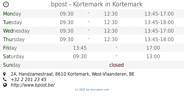
bpost - Kortemark
Handzamestraat 2A, Kortemark
Post office
read more
13.825 km
bpost
Handzamestraat 2A, Kortemark
Post office
read more
14.191 km
Postpunt Never Ending Story
Havenstraat 5, Brugge
Post office
read more
14.341 km
bpost
Dorpsstraat 73, Damme
Post office
read more
14.341 km
bpost SA
Dorpsstraat 73, Damme
Post office
read more
14.345 km
bpost - Sijsele
Dorpsstraat 73, Damme
Post office
read more
14.349 km
bpost
BEERNEGEMSTR 46, Tielt
Post office
read more
14.357 km
Postpunt T Vershoekske
Tielt
Post office
read more
14.576 km
De Post - Ruiselede
Ruiselede
Post office
read more
14.605 km
bpost
Kasteelstraat 8, Ruiselede
Post office
read more
15.72 km
bpost
Marktplaats 31, Hooglede
Post office
read more
17.088 km
bpost - Oudenburg
Hoogstraat 28c, Oudenburg
Post office
read more
17.25 km
bpost SA
Weststraat 18, Oudenburg
Post office
read more
19.096 km
bpost
Sint Jansstraat 54, Staden
Post office
read more
📑
all categories
Accounting
Administrative area level 1
Administrative area level 2
Airport
Amusement park
Aquarium
Art gallery
Atm
Bakery
Bank
Bar
Beauty salon
Bicycle store
Book store
Bowling alley
Bus station
Cafe
Campground
Car dealer
Car rental
Car repair
Car wash
Casino
Cemetery
Church
City hall
Clothing store
Colloquial area
Convenience store
Country
Courthouse
Dentist
Department store
Doctor
Electrician
Electronics store
Embassy
Finance
Fire station
Florist
Food
Funeral home
Furniture store
Gas station
General contractor
Grocery or supermarket
Gym
Hair care
Hardware store
Health
Hindu Temple
Home goods store
Hospital
Insurance agency
Jewelry store
Laundry
Lawyer
Library
Light rail station
Liquor store
Local government office
Locality
Locksmith
Lodging
Meal delivery
Meal takeaway
Mosque
Movie rental
Movie theater
Moving company
Museum
Natural feature
Neighborhood
Night club
Painter
Park
Parking
Pet store
Pharmacy
Physiotherapist
Place of worship
Plumber
Point of interest
Police
Political
Post office
Premise
Real estate agency
Restaurant
Roofing contractor
Route
Rv park, camping
School
Shoe store
Shopping mall
Spa
Stadium
Storage
Store
Subpremise
Subway station
Supermarket
Synagogue
Taxi stand
Train station
Transit station
Travel agency
University
Veterinary care
Zoo
sublocality level 1
sublocality level 2
sublocality level 3
↑