Post office nearby bpost
Coronavirus disease (COVID-19) Situation
confirmed cases
4861695
deaths
34376
Belgium
Post office nearby bpost
bpost
Hondstraat 1, Poperinge Belgique
contacts phone
:
+32
Latitude:
50.8548354
, Longitude:
2.7227421
read more
nearest Post office
86 m
De Post - Poperinge
Poperinge
Post office
read more
102 m
bpost - Poperinge
Hondstraat 1, Poperinge
Post office
read more
6.136 km
Postpunt Proxy Delhaize Proven
Obterrestraat 44, Poperinge
Post office
read more
6.464 km
La Poste
16 Rue de la Mairie, Boeschepe
Post office
read more
6.762 km
Postpunt Spar Retail Vlamertinge
Ieper
Post office
read more
6.762 km
Postpunt Spar Retail Vlamertinge
Ypres
Post office
read more
10.739 km
Postpunt Spar Lemahieu
Ypres
Post office
read more
10.739 km
Postpunt Spar Lemahieu
Ieper
Post office
read more
10.817 km
De Post - Heuvelland
Bergstraat 18/A, Heuvelland
Post office
read more
10.821 km
bpost
Bergstraat 18A, Heuvelland
Post office
read more
11.177 km
bpost
Studentenstraat 10, Ieper
Post office
read more
11.265 km
bpost
STUDENTENSTR 10, Ieper
Post office
read more
12.879 km
La Poste
2 Rue de Lille, Bailleul
Post office
read more
14.069 km
Postpunt Spar Nieuwkerke
Markt 65, Heuvelland
Post office
read more
15.095 km
bpost
Vijverstraat 9, Langemark-Poelkapelle
Post office
read more
15.834 km
bpost
PLACE 25, Mesen
Post office
read more
18.372 km
bpost
Ieperstraat 39, Zonnebeke
Post office
read more
19.199 km
La Poste
672 Rue d'Armentières, Nieppe
Post office
read more
20.975 km
bpost
MARKT 25, Houthulst
Post office
read more
21.664 km
La Poste
10 Rue au Vent, Frelinghien
Post office
read more
21.945 km
Puppynck Sebastien
26 Rue du 8 Mai 1945, Armentières
Post office
read more
23.838 km
La Poste
2 PLACE JEAN LEVASSEUR, Fleurbaix
Post office
read more
27.947 km
Post Bray-Dunes
10 Avenue du Général de Gaulle, Bray-Dunes
Post office
read more
29.5 km
bpost
Handzamestraat 2A, Kortemark
Post office
read more
29.521 km
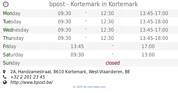
bpost - Kortemark
Handzamestraat 2A, Kortemark
Post office
read more
📑
all categories
Accounting
Administrative area level 1
Administrative area level 2
Airport
Amusement park
Aquarium
Art gallery
Atm
Bakery
Bank
Bar
Beauty salon
Bicycle store
Book store
Bowling alley
Bus station
Cafe
Campground
Car dealer
Car rental
Car repair
Car wash
Casino
Cemetery
Church
City hall
Clothing store
Colloquial area
Convenience store
Country
Courthouse
Dentist
Department store
Doctor
Electrician
Electronics store
Embassy
Finance
Fire station
Florist
Food
Funeral home
Furniture store
Gas station
General contractor
Grocery or supermarket
Gym
Hair care
Hardware store
Health
Hindu Temple
Home goods store
Hospital
Insurance agency
Jewelry store
Laundry
Lawyer
Library
Light rail station
Liquor store
Local government office
Locality
Locksmith
Lodging
Meal delivery
Meal takeaway
Mosque
Movie rental
Movie theater
Moving company
Museum
Natural feature
Neighborhood
Night club
Painter
Park
Parking
Pet store
Pharmacy
Physiotherapist
Place of worship
Plumber
Point of interest
Police
Political
Post office
Premise
Real estate agency
Restaurant
Roofing contractor
Route
Rv park, camping
School
Shoe store
Shopping mall
Spa
Stadium
Storage
Store
Subpremise
Subway station
Supermarket
Synagogue
Taxi stand
Train station
Transit station
Travel agency
University
Veterinary care
Zoo
sublocality level 1
sublocality level 2
sublocality level 3
↑