Post office nearby bpost
Coronavirus disease (COVID-19) Situation
confirmed cases
4861695
deaths
34376
Belgium
Post office nearby bpost
bpost
Brusselstraat 8, Brugge België
contacts phone
:
+32
Latitude:
51.329008
, Longitude:
3.1815232
read more
nearest Post office
68 m
bpost - Zeebrugge
Brusselstraat 8
Post office
read more
3.833 km
bpost - Blankenberge
Steenstraat 16, Blankenberge
Post office
read more
4.074 km
bpost
De Smet de Naeyerlaan 147, Blankenberge
Post office
read more
7.324 km
De Post - Zuienkerke
Kerkstraat 17, Zuienkerke
Post office
read more
7.35 km
bpost SA
Kerkstraat 17, Zuienkerke
Post office
read more
7.35 km
bpost
Kerkstraat 17, Zuienkerke
Post office
read more
11.097 km
Toerisme Damme
Jacob van Maerlantstraat 3, Damme
Post office
read more
11.097 km
tourism Damme
Jacob van Maerlantstraat 3, Damme
Post office
read more
12.092 km
bpost
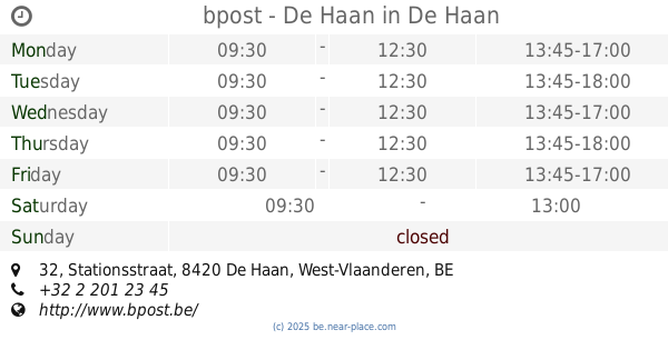
Stationsstraat 32, De Haan
Post office
read more
12.093 km
bpost - De Haan
Stationsstraat 32, De Haan
Post office
read more
12.171 km
Postpunt Never Ending Story
Havenstraat 5, Brugge
Post office
read more
12.739 km
Postpunt GB Scheepsdale
Brugge
Post office
read more
13.976 km
bpost
Smedenstraat 57-59, Brugge
Post office
read more
14.14 km
Postpunt Algemene Voeding Moerkerke
Vissersstraat 82, Damme
Post office
read more
14.353 km
Postpunt Press SH Brugge Katelij
Bruges
Post office
read more
14.7 km
bpost
Gistelsesteenweg 501
Post office
read more
14.7 km
bpost
Gistelsesteenweg 540, Brugge
Post office
read more
14.705 km
bpost
Maalse Steenweg 334, Brugge
Post office
read more
14.715 km
Postpunt Carrefour Brugge Sint-kruis
Maalse Steenweg 334, Brugge
Post office
read more
14.907 km
bpost
GASTON ROELANDTSPL. 6
Post office
read more
14.907 km
bpost - Assebroek
GASTON ROELANDTSPL. 6
Post office
read more
17.361 km
bpost - Sijsele
Dorpsstraat 73, Damme
Post office
read more
17.367 km
bpost SA
Dorpsstraat 73, Damme
Post office
read more
17.367 km
bpost
Dorpsstraat 73, Damme
Post office
read more
17.45 km
bpost - Jabbeke
Jabbeke
Post office
read more
📑
all categories
Accounting
Administrative area level 1
Administrative area level 2
Airport
Amusement park
Aquarium
Art gallery
Atm
Bakery
Bank
Bar
Beauty salon
Bicycle store
Book store
Bowling alley
Bus station
Cafe
Campground
Car dealer
Car rental
Car repair
Car wash
Casino
Cemetery
Church
City hall
Clothing store
Colloquial area
Convenience store
Country
Courthouse
Dentist
Department store
Doctor
Electrician
Electronics store
Embassy
Finance
Fire station
Florist
Food
Funeral home
Furniture store
Gas station
General contractor
Grocery or supermarket
Gym
Hair care
Hardware store
Health
Hindu Temple
Home goods store
Hospital
Insurance agency
Jewelry store
Laundry
Lawyer
Library
Light rail station
Liquor store
Local government office
Locality
Locksmith
Lodging
Meal delivery
Meal takeaway
Mosque
Movie rental
Movie theater
Moving company
Museum
Natural feature
Neighborhood
Night club
Painter
Park
Parking
Pet store
Pharmacy
Physiotherapist
Place of worship
Plumber
Point of interest
Police
Political
Post office
Premise
Real estate agency
Restaurant
Roofing contractor
Route
Rv park, camping
School
Shoe store
Shopping mall
Spa
Stadium
Storage
Store
Subpremise
Subway station
Supermarket
Synagogue
Taxi stand
Train station
Transit station
Travel agency
University
Veterinary care
Zoo
sublocality level 1
sublocality level 2
sublocality level 3
↑