Pharmacy nearby Milan Apotica
Coronavirus disease (COVID-19) Situation
confirmed cases
4861695
deaths
34376
Belgium
Pharmacy nearby Milan Apotica
Milan Apotica
Rue Joseph II 17, Bruxelles Belgium
contacts phone
:
+32
Latitude:
50.8460262
, Longitude:
4.3708598
read more
nearest Pharmacy
364 m
Apotheek Madou
Madouplein 1, Sint-Joost-ten-Node
Pharmacy
read more
456 m
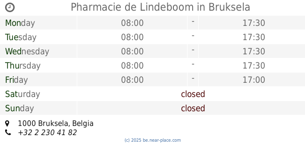
Pharmacie de Lindeboom
Brussels
Pharmacy
read more
495 m
Multipharma
Chaussée de Louvain 81-83, Saint-Josse-ten-Noode
Pharmacy
read more
560 m
Pharmacie Longueville
Rue de l'Enseignement 38, Bruxelles
Pharmacy
read more
607 m
De Lindeboom Adviesapotheek
Rue Montoyer 58, Bruxelles
Pharmacy
read more
607 m
PHARMACIE
1000, Rue Montoyer 58, Bruxelles
Pharmacy
read more
650 m
Apotheek Van Kersschaever
Brussel
Pharmacy
read more
677 m
Pharmacie Perez
202, Leuvensesteenweg, Sint-Joost-ten-Node
Pharmacy
read more
695 m
Lecompte C.
Rue Braemt 56, Saint-Josse-ten-Noode
Pharmacy
read more
815 m
Novelty sprl
Ravensteinstraat 52, Brussel
Pharmacy
read more
897 m
Apotheek Duby
Elsene
Pharmacy
read more
897 m
Pharmacie Duby
Ixelles
Pharmacy
read more
917 m
Pharmacie du Parnasse
Ixelles
Pharmacy
read more
917 m
Pharmacie Coudenberg
Brussels
Pharmacy
read more
953 m
Cynara Apotheek
Archimedesstraat 29, Brussel
Pharmacy
read more
956 m
Pharmacie Berlaymont
Rue Archimède 29, Bruxelles
Pharmacy
read more
962 m
Apotheek Ambiorix
Brussel
Pharmacy
read more
964 m
Apotheek Pharmacie
Paviastraat 45, Brussel
Pharmacy
read more
964 m
Apotheek Pharmacie
Rue de Pavie 45, Bruxelles
Pharmacy
read more
1.081 km
Pharmacie LloydsPharma Schuman
Oudergemlaan 14, Etterbeek
Pharmacy
read more
1.087 km
Sevenants / Line
Waversesteenweg 50, Elsene
Pharmacy
read more
1.134 km
Basunga-Ndombasi / Nkelele
Elsensesteenweg 26, Elsene
Pharmacy
read more
1.139 km
Apotheek Kruidtuin Saint-Louis
Kruidtuinlaan 36, Brussel
Pharmacy
read more
1.162 km
Neos Coloniales (Pharmacie)
Elsene
Pharmacy
read more
1.323 km
Pharmacie Cosmopharma
Rue de Malines 41, Bruxelles
Pharmacy
read more
📑
all categories
Accounting
Administrative area level 1
Administrative area level 2
Airport
Amusement park
Aquarium
Art gallery
Atm
Bakery
Bank
Bar
Beauty salon
Bicycle store
Book store
Bowling alley
Bus station
Cafe
Campground
Car dealer
Car rental
Car repair
Car wash
Casino
Cemetery
Church
City hall
Clothing store
Colloquial area
Convenience store
Country
Courthouse
Dentist
Department store
Doctor
Electrician
Electronics store
Embassy
Finance
Fire station
Florist
Food
Funeral home
Furniture store
Gas station
General contractor
Grocery or supermarket
Gym
Hair care
Hardware store
Health
Hindu Temple
Home goods store
Hospital
Insurance agency
Jewelry store
Laundry
Lawyer
Library
Light rail station
Liquor store
Local government office
Locality
Locksmith
Lodging
Meal delivery
Meal takeaway
Mosque
Movie rental
Movie theater
Moving company
Museum
Natural feature
Neighborhood
Night club
Painter
Park
Parking
Pet store
Pharmacy
Physiotherapist
Place of worship
Plumber
Point of interest
Police
Political
Post office
Premise
Real estate agency
Restaurant
Roofing contractor
Route
Rv park, camping
School
Shoe store
Shopping mall
Spa
Stadium
Storage
Store
Subpremise
Subway station
Supermarket
Synagogue
Taxi stand
Train station
Transit station
Travel agency
University
Veterinary care
Zoo
sublocality level 1
sublocality level 2
sublocality level 3
↑