Pharmacy nearby Apotheek Van Dessel
Belgium
Pharmacy nearby Apotheek Van Dessel
Apotheek Van Dessel
Brusselbaan 90, Affligem Bélgica
contacts phone
:
+32
Latitude:
50.9132877
, Longitude:
4.1047575
read more
nearest Pharmacy
226 m
Apotheek Libens-Van Tichelen
Brusselbaan 134, Affligem
Pharmacy
read more
1.759 km
Apotheek Derijck
Kapellestraat 31/A, Aalst
Pharmacy
read more
2.281 km
Belledaal
Potaardestraat, Affligem
Pharmacy
read more
2.603 km
Apotheek Hellings Aalst
Hogeweg 143, Erembodegem (Aalst)
Pharmacy
read more
2.731 km
apoteek paracelsus
Kempinnestraat 2, Aalst
Pharmacy
read more
2.736 km
Paracelsus nv
Kempinnestraat 17, Aalst
Pharmacy
read more
2.968 km
Keymolen Apotheek bvba
Ternatsestraat 85, Affligem
Pharmacy
read more
3.069 km
Apoteek Vercammen
Immerzeeldreef 61, Aalst
Pharmacy
read more
3.196 km
Apotheek Mahieu
Hogeweg 2, Aalst
Pharmacy
read more
3.265 km
Apotheek Van der Weeen
Stationsstraat 27, Denderleeuw
Pharmacy
read more
3.556 km
Boel E.
Keppestraat 1, Aalst
Pharmacy
read more
3.659 km
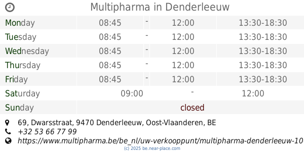
Multipharma
Dwarsstraat 69, Denderleeuw
Pharmacy
read more
3.812 km
De Bie T.
Langestraat 239, Aalst
Pharmacy
read more
3.854 km
Apotheek Kelles
Moorsel-Dorp 21, Moorsel (Aalst)
Pharmacy
read more
3.944 km
Apotheek Walraevens NV
Nieuwbaan 24, Ternat
Pharmacy
read more
4.346 km
Apotheek C&M De Hondt
Stationsstraat 191, Liedekerke
Pharmacy
read more
4.864 km
apotheek Mijlbeek
Moorselbaan 146, Aalst
Pharmacy
read more
4.878 km
Apotheek Ilse Caudron
Baardegem-Dorp 87, Aalst
Pharmacy
read more
4.903 km
Apotheek Herdewijn Pierrette
Pontstraat 78, Aalst
Pharmacy
read more
5.236 km
Apotheek Audenaert / Anne-Marie
Korte Zoutstraat 11, Aalst
Pharmacy
read more
5.302 km
Multipharma
Kanunnik Colinetstraat 11, Aalst
Pharmacy
read more
5.303 km
Pharmacy Berghmans BVBA
Iddergemstraat 46, Denderleeuw
Pharmacy
read more
5.477 km
Apotheek Renneboog
Nieuwstraat 9, Aalst
Pharmacy
read more
5.775 km
De Buysscher / Apotheek
Steenweg op Brussel 138, Opwijk
Pharmacy
read more
5.873 km
Poppe / Etienne
Denderstraat 14, Aalst
Pharmacy
read more
📑
all categories
Accounting
Administrative area level 1
Administrative area level 2
Airport
Amusement park
Aquarium
Art gallery
Atm
Bakery
Bank
Bar
Beauty salon
Bicycle store
Book store
Bowling alley
Bus station
Cafe
Campground
Car dealer
Car rental
Car repair
Car wash
Casino
Cemetery
Church
City hall
Clothing store
Colloquial area
Convenience store
Country
Courthouse
Dentist
Department store
Doctor
Electrician
Electronics store
Embassy
Finance
Fire station
Florist
Food
Funeral home
Furniture store
Gas station
General contractor
Grocery or supermarket
Gym
Hair care
Hardware store
Health
Hindu Temple
Home goods store
Hospital
Insurance agency
Jewelry store
Laundry
Lawyer
Library
Light rail station
Liquor store
Local government office
Locality
Locksmith
Lodging
Meal delivery
Meal takeaway
Mosque
Movie rental
Movie theater
Moving company
Museum
Natural feature
Neighborhood
Night club
Painter
Park
Parking
Pet store
Pharmacy
Physiotherapist
Place of worship
Plumber
Point of interest
Police
Political
Post office
Premise
Real estate agency
Restaurant
Roofing contractor
Route
Rv park, camping
School
Shoe store
Shopping mall
Spa
Stadium
Storage
Store
Subpremise
Subway station
Supermarket
Synagogue
Taxi stand
Train station
Transit station
Travel agency
University
Veterinary care
Zoo
sublocality level 1
sublocality level 2
sublocality level 3
↑