Park nearby Speelplein Leopoldstad
Coronavirus disease (COVID-19) Situation
confirmed cases
4861695
deaths
34376
Belgium
Park nearby Speelplein Leopoldstad
Speelplein Leopoldstad
1040 Etterbeek, Belgium
contacts phone
:
+32
Latitude:
50.8285323
, Longitude:
4.3828313
larger map & directions
read more
nearest Park
254 m
Plaine de Jeux Albert II
Ixelles
Park
read more
307 m
Parc ALBERT II
Place Adolphe Sax, Ixelles
Park
read more
307 m
Parc ALBERT II
Adolphe Saxplein, Elsene
Park
read more
396 m
Plaine de Jeux l'Aulne
Ixelles
Park
read more
548 m
Jardins participatifs d'Etterbeek
Avenue Nouvelle, Etterbeek
Park
read more
548 m
Jardins participatifs d'Etterbeek
Nieuwelaan, Etterbeek
Park
read more
617 m
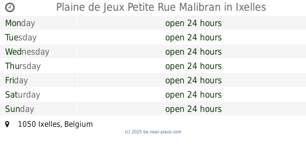
Plaine de Jeux Petite Rue Malibran
Ixelles
Park
read more
641 m
Jardin Collectif Gray
Etterbeek
Park
read more
641 m
Collectif Gray Garden
Etterbeek
Park
read more
694 m
Jardin Jean-Felix Hap
Etterbeek
Park
read more
694 m
Jean-Felix Hap Garden
Etterbeek
Park
read more
731 m
Parking vijwers van Elsene
Belvédèrestraat 21, Elsene
Park
read more
803 m
Square Forte Dei Marmi
Place Jourdan, Etterbeek
Park
read more
803 m
Square Forte Dei Marmi
Jourdanplein, Etterbeek
Park
read more
811 m
Park Jadot
Ixelles
Park
read more
861 m
Etangs d'Ixelles
Rue Guillaume Stocq 3, Ixelles
Park
read more
861 m
Vijvers van Elsene
Guillaume Stocqstraat 3, Elsene
Park
read more
883 m
Parc Keith Haring Park
Sint-Pieterssteenweg 100, Etterbeek
Park
read more
883 m
Parc Keith Haring Park
Chaussée Saint-Pierre 100, Etterbeek
Park
read more
899 m
Viaductpark
Viaductstraat 133, Elsene
Park
read more
945 m
Parc Jo Heyne
Place Jourdan 48, Etterbeek
Park
read more
945 m
Park Jo Heyne
Place Jourdan 48, Etterbeek
Park
read more
945 m
Park Jo Heyne
Jourdanplein 48, Etterbeek
Park
read more
1.09 km
Plaine de Jeux Rinsdelle
Etterbeek
Park
read more
1.09 km
Speelplein Rinsdelle
Etterbeek
Park
read more
📑
all categories
Accounting
Administrative area level 1
Administrative area level 2
Airport
Amusement park
Aquarium
Art gallery
Atm
Bakery
Bank
Bar
Beauty salon
Bicycle store
Book store
Bowling alley
Bus station
Cafe
Campground
Car dealer
Car rental
Car repair
Car wash
Casino
Cemetery
Church
City hall
Clothing store
Colloquial area
Convenience store
Country
Courthouse
Dentist
Department store
Doctor
Electrician
Electronics store
Embassy
Finance
Fire station
Florist
Food
Funeral home
Furniture store
Gas station
General contractor
Grocery or supermarket
Gym
Hair care
Hardware store
Health
Hindu Temple
Home goods store
Hospital
Insurance agency
Jewelry store
Laundry
Lawyer
Library
Light rail station
Liquor store
Local government office
Locality
Locksmith
Lodging
Meal delivery
Meal takeaway
Mosque
Movie rental
Movie theater
Moving company
Museum
Natural feature
Neighborhood
Night club
Painter
Park
Parking
Pet store
Pharmacy
Physiotherapist
Place of worship
Plumber
Point of interest
Police
Political
Post office
Premise
Real estate agency
Restaurant
Roofing contractor
Route
Rv park, camping
School
Shoe store
Shopping mall
Spa
Stadium
Storage
Store
Subpremise
Subway station
Supermarket
Synagogue
Taxi stand
Train station
Transit station
Travel agency
University
Veterinary care
Zoo
sublocality level 1
sublocality level 2
sublocality level 3
↑