Park nearby Jardins Suspendus de la Cite Administrative
Coronavirus disease (COVID-19) Situation
confirmed cases
4861695
deaths
34376
Belgium
Park nearby Jardins Suspendus de la Cite Administrative
Jardins Suspendus de la Cite Administrative
Brussels Bélgica
contacts phone
:
+32
Latitude:
50.8511963
, Longitude:
4.3627746
read more
nearest Park
73 m
Tuin van Pechère
Onze-Lieve-Vrouw-ter-Sneeuw,1000, Brussel
Park
read more
332 m
Barricaden
Place des Barricades, Bruxelles
Park
read more
332 m
Barricaden
Barricadenplein, Brussel
Park
read more
408 m
Botanical Garden
Boulevard Saint-Lazare, Saint-Josse-ten-Noode
Park
read more
439 m
Plaine de Jeux Frick
Saint-Josse-ten-Noode
Park
read more
648 m
Parque de Bruselas
Brussels
Park
read more
648 m
Parc de Bruxelles
Bruxelles
Park
read more
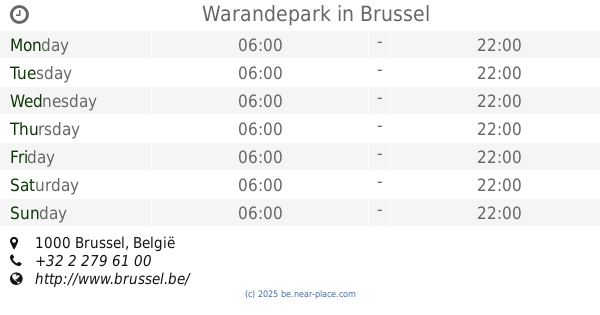
648 m
Warandepark
Brussel
Park
read more
683 m
Jeanneke-Pis
Getrouwheidsgang 10-12, Brussel
Park
read more
809 m
Potager Alhambra Moestuin
Rue de l'Epargne 29, Bruxelles
Park
read more
809 m
Potager Alhambra
Spaarstraat 29, Brussel
Park
read more
837 m
Square de la Putterie
Brussels
Park
read more
837 m
Square de la Putterie
Bruxelles
Park
read more
837 m
Square de la Putterie
Brüssel
Park
read more
837 m
Square de la Putterie
Bruksela
Park
read more
840 m
Speltraject In Het Koningshuis
Brussel
Park
read more
840 m
Jeu Parcours A la Maison du Roi
Brussels
Park
read more
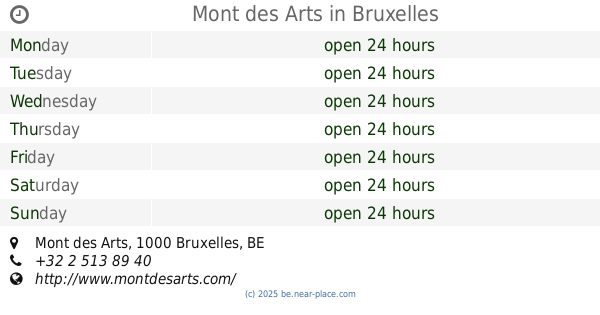
919 m
Mont des Arts
Mont des Arts, Bruxelles
Park
read more
919 m
Monte de las Artes
Mont des Arts, Bruxelles
Park
read more
982 m
Palais des Academies Garden
Brussels
Park
read more
996 m
Protjespark
Avenue des Arts 46, Bruxelles
Park
read more
996 m
Protjespark
Kunstlaan 46, Brussel
Park
read more
1.051 km
Square Frère-Orban Park
Bruxelles
Park
read more
1.189 km
Plaine de Jeux Rasquinet
Schaerbeek
Park
read more
1.217 km
Boerderij van het Maximiliaanpark
Schipperijkaai 2, Brussel
Park
read more
📑
all categories
Accounting
Administrative area level 1
Administrative area level 2
Airport
Amusement park
Aquarium
Art gallery
Atm
Bakery
Bank
Bar
Beauty salon
Bicycle store
Book store
Bowling alley
Bus station
Cafe
Campground
Car dealer
Car rental
Car repair
Car wash
Casino
Cemetery
Church
City hall
Clothing store
Colloquial area
Convenience store
Country
Courthouse
Dentist
Department store
Doctor
Electrician
Electronics store
Embassy
Finance
Fire station
Florist
Food
Funeral home
Furniture store
Gas station
General contractor
Grocery or supermarket
Gym
Hair care
Hardware store
Health
Hindu Temple
Home goods store
Hospital
Insurance agency
Jewelry store
Laundry
Lawyer
Library
Light rail station
Liquor store
Local government office
Locality
Locksmith
Lodging
Meal delivery
Meal takeaway
Mosque
Movie rental
Movie theater
Moving company
Museum
Natural feature
Neighborhood
Night club
Painter
Park
Parking
Pet store
Pharmacy
Physiotherapist
Place of worship
Plumber
Point of interest
Police
Political
Post office
Premise
Real estate agency
Restaurant
Roofing contractor
Route
Rv park, camping
School
Shoe store
Shopping mall
Spa
Stadium
Storage
Store
Subpremise
Subway station
Supermarket
Synagogue
Taxi stand
Train station
Transit station
Travel agency
University
Veterinary care
Zoo
sublocality level 1
sublocality level 2
sublocality level 3
↑