Park nearby Camping Bruxelles Open Sky
Coronavirus disease (COVID-19) Situation
confirmed cases
4861695
deaths
34376
Belgium
Park nearby Camping Bruxelles Open Sky
Camping Bruxelles Open Sky
205, Chaussée de Wavre, 1050, Ixelles, BE Belgium
contacts phone
:
+32 467 64 58 66
website:
cielouvertcamping.wordpress.com
Latitude:
50.8357989
, Longitude:
4.3736508
larger map & directions
read more
nearest Park
144 m
Viaductpark
Viaductstraat 133, Elsene
Park
read more
406 m
Square châtaillon-plage
Rue de la Crèche 6, Ixelles
Park
read more
435 m
Square Forte Dei Marmi
Place Jourdan, Etterbeek
Park
read more
467 m
Collectif Gray Garden
Etterbeek
Park
read more
467 m
Jardin Collectif Gray
Etterbeek
Park
read more
510 m
Park Jo Heyne
Jourdanplein 48, Etterbeek
Park
read more
510 m
Parc Jo Heyne
Place Jourdan 48, Etterbeek
Park
read more
510 m
Park Jo Heyne
Place Jourdan 48, Etterbeek
Park
read more
567 m
Parque Leopoldo
Belgium
Park
read more
567 m
Leopold Park
Belgium
Park
read more
567 m
Parc Léopold
Rue Belliard, Bruxelles
Park
read more
585 m
Place de Carl
Unnamed Road 1050, Ixelles
Park
read more
714 m
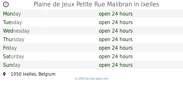
Plaine de Jeux Petite Rue Malibran
Ixelles
Park
read more
868 m
Square Frère-Orban Park
Bruxelles
Park
read more
877 m
Jean-Felix Hap Garden
Etterbeek
Park
read more
877 m
Jardin Jean-Felix Hap
Etterbeek
Park
read more
877 m
Parc Keith Haring Park
Chaussée Saint-Pierre 100, Etterbeek
Park
read more
886 m
Protjespark
Kunstlaan 46, Brussel
Park
read more
886 m
Protjespark
Avenue des Arts 46, Bruxelles
Park
read more
982 m
Jardin de la Vallée du Maelbeek
Brussel
Park
read more
982 m
Jardin de la Vallée du Maelbeek
Brussels
Park
read more
982 m
Vallée du Maelbeek Garden
Brussels
Park
read more
982 m
Vallée du Maelbeek Garden
Brussel
Park
read more
1.105 km
Memorial to the victims of Brussels bombings
Wetstraat 248, Brussel
Park
read more
1.105 km
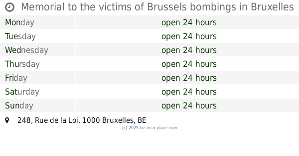
Memorial to the victims of Brussels bombings
Rue de la Loi 248, Bruxelles
Park
read more
📑
all categories
Accounting
Administrative area level 1
Administrative area level 2
Airport
Amusement park
Aquarium
Art gallery
Atm
Bakery
Bank
Bar
Beauty salon
Bicycle store
Book store
Bowling alley
Bus station
Cafe
Campground
Car dealer
Car rental
Car repair
Car wash
Casino
Cemetery
Church
City hall
Clothing store
Colloquial area
Convenience store
Country
Courthouse
Dentist
Department store
Doctor
Electrician
Electronics store
Embassy
Finance
Fire station
Florist
Food
Funeral home
Furniture store
Gas station
General contractor
Grocery or supermarket
Gym
Hair care
Hardware store
Health
Hindu Temple
Home goods store
Hospital
Insurance agency
Jewelry store
Laundry
Lawyer
Library
Light rail station
Liquor store
Local government office
Locality
Locksmith
Lodging
Meal delivery
Meal takeaway
Mosque
Movie rental
Movie theater
Moving company
Museum
Natural feature
Neighborhood
Night club
Painter
Park
Parking
Pet store
Pharmacy
Physiotherapist
Place of worship
Plumber
Point of interest
Police
Political
Post office
Premise
Real estate agency
Restaurant
Roofing contractor
Route
Rv park, camping
School
Shoe store
Shopping mall
Spa
Stadium
Storage
Store
Subpremise
Subway station
Supermarket
Synagogue
Taxi stand
Train station
Transit station
Travel agency
University
Veterinary care
Zoo
sublocality level 1
sublocality level 2
sublocality level 3
↑