Gas station nearby Total
Belgium
Gas station nearby Total
Total
Lange Meire 54, Laarne België
contacts phone
:
+32
Latitude:
51.030387
, Longitude:
3.8647705
read more
nearest Gas station
1.779 km
Esso
Heirweg 77, Laarne
Gas station
read more
1.883 km
Texaco
Eekhoekstraat 19, Laarne
Gas station
read more
1.883 km
Total
Eekhoekstraat 19, Laarne
Gas station
read more
1.896 km
TOTAL Tankstelle
Eekhoekstraat 19, Laarne
Gas station
read more
1.896 km
Total - Laarne, DEWI RETAIL BVBA
Eekhoekstraat 19, Laarne
Gas station
read more
2.144 km
Gabriëls
Heirweg 43, Kalken
Gas station
read more
2.566 km
Total
Nieuwe Brug 1, Wetteren
Gas station
read more
2.566 km
TOTAL Tankstelle
Nieuwe Brug 1, Wetteren
Gas station
read more
2.566 km
Total - Overschelde DEWI RETAIL BVBA
Nieuwe Brug 1, Wetteren
Gas station
read more
2.602 km
Vera Gas
Peperstraat 7, Wetteren
Gas station
read more
3.218 km
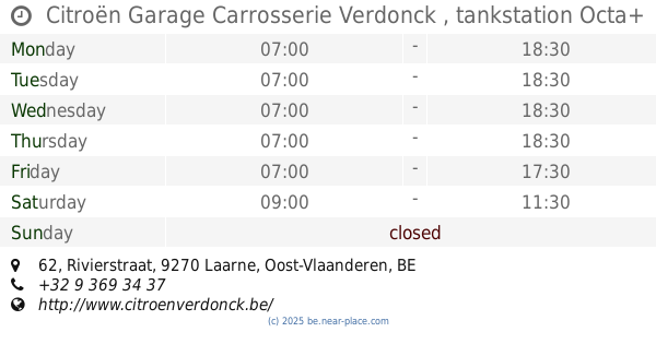
Citroën Garage Carrosserie Verdonck , tankstation Octa+
Rivierstraat 62, Laarne
Gas station
read more
3.585 km
Q8 easy
Rivierstraat 57, Laarne
Gas station
read more
3.597 km
Carwash-Benzine station
Warandelaan 12, Wetteren
Gas station
read more
4.243 km
Desimpel
Laarnebaan 1, Destelbergen
Gas station
read more
4.264 km
DATS 24
Dendermondesteenweg 694, Destelbergen
Gas station
read more
4.74 km
Shell
Zuidlaan 296, Wetteren
Gas station
read more
5.037 km
Esso
Brusselsesteenweg,485, Melle
Gas station
read more
5.088 km
Texaco service Station
Dendermondsesteenweg 100, Laarne
Gas station
read more
5.278 km
Total
Brusselsesteenweg 314, Melle
Gas station
read more
5.714 km
Rasschaert
Wetterensteenweg 5, Wichelen
Gas station
read more
5.739 km
Power
Wetterensteenweg 5, Wichelen
Gas station
read more
5.87 km
Total Kalken E17 richting Antwerpen
E17 Gent-Antwerpen, Laarne
Gas station
read more
5.87 km
Total
E17 Gent-Antwerpen, Laarne
Gas station
read more
6.055 km
Total
E17 Antwerpen-gent, Laarne
Gas station
read more
6.061 km
Total
Gent, E17 Antwerpen, Laarne
Gas station
read more
📑
all categories
Accounting
Administrative area level 1
Administrative area level 2
Airport
Amusement park
Aquarium
Art gallery
Atm
Bakery
Bank
Bar
Beauty salon
Bicycle store
Book store
Bowling alley
Bus station
Cafe
Campground
Car dealer
Car rental
Car repair
Car wash
Casino
Cemetery
Church
City hall
Clothing store
Colloquial area
Convenience store
Country
Courthouse
Dentist
Department store
Doctor
Electrician
Electronics store
Embassy
Finance
Fire station
Florist
Food
Funeral home
Furniture store
Gas station
General contractor
Grocery or supermarket
Gym
Hair care
Hardware store
Health
Hindu Temple
Home goods store
Hospital
Insurance agency
Jewelry store
Laundry
Lawyer
Library
Light rail station
Liquor store
Local government office
Locality
Locksmith
Lodging
Meal delivery
Meal takeaway
Mosque
Movie rental
Movie theater
Moving company
Museum
Natural feature
Neighborhood
Night club
Painter
Park
Parking
Pet store
Pharmacy
Physiotherapist
Place of worship
Plumber
Point of interest
Police
Political
Post office
Premise
Real estate agency
Restaurant
Roofing contractor
Route
Rv park, camping
School
Shoe store
Shopping mall
Spa
Stadium
Storage
Store
Subpremise
Subway station
Supermarket
Synagogue
Taxi stand
Train station
Transit station
Travel agency
University
Veterinary care
Zoo
sublocality level 1
sublocality level 2
sublocality level 3
↑