Gas station nearby Total
Belgium
Gas station nearby Total
Total
Dendermondesteenweg 329, Destelbergen België
contacts phone
:
+32
Latitude:
51.0552343
, Longitude:
3.7804068
read more
nearest Gas station
1.392 km
Texaco De Maesschalck
Damvalleistraat 79, Destelbergen
Gas station
read more
1.399 km
Q8
Dendermondesteenweg 68, Destelbergen
Gas station
read more
1.614 km
AB+ Destelbergen
Dendermondsesteenweg, Destelbergen
Gas station
read more
1.741 km
Q8
Victor Braeckmanlaan 158, Gent
Gas station
read more
1.961 km
Lukoil SINT-AMANDSBERG
Antwerpsesteenweg 758, ST. Amandsberg
Gas station
read more
1.996 km
Texaco
Antwerpsesteenweg 729, Gent
Gas station
read more
2.092 km
Power
Dendermondsesteenweg 298, St Amandsberg
Gas station
read more
2.763 km
LUKOIL Vlaamse Kaai
Vlaamsekaai 106, Gent
Gas station
read more
2.925 km
Q8
Brusselsesteenweg 335, Gent-Gentbrugge
Gas station
read more
2.971 km
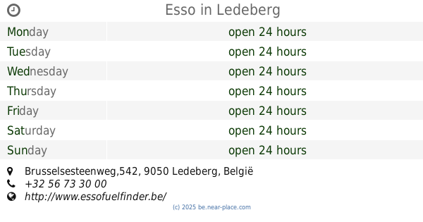
Esso
Brusselsesteenweg,542, Ledeberg
Gas station
read more
2.974 km
Lukoil Gentbrugge
Brusselsesteenweg 679, Gentbrugge
Gas station
read more
2.976 km
Q8 easy
Brusselsesteenweg 530, Gent-Ledeberg
Gas station
read more
2.99 km
Lavadero Auto
Brusselsesteenweg 131, Gent
Gas station
read more
3.004 km
Desimpel
Laarnebaan 1, Destelbergen
Gas station
read more
3.025 km
Gabriels
Afrikalaan 70, Gent
Gas station
read more
3.026 km
Q8
Antwerpsesteenweg 1114, Gent-Oostakker
Gas station
read more
3.084 km
Shell Express
Brusselsesteenweg 735, Gent
Gas station
read more
3.094 km
Shell
Brusselsesteenweg 735, Gent
Gas station
read more
3.123 km
Gabiëls Tankstation
Gent
Gas station
read more
3.123 km
Gabiëls Tankstation
Ghent
Gas station
read more
3.153 km
Total
Groenstraat 4, Gent
Gas station
read more
3.293 km
Hubble Wash Hand Carwash
Afrikalaan, Gent
Gas station
read more
4.142 km
Total
Hundelgemsesteenweg 471, Gent
Gas station
read more
4.817 km
Q8 Service Stations
Corneel Heymanslaan 9, Gent
Gas station
read more
4.865 km
Texaco
Eekhoekstraat 19, Laarne
Gas station
read more
📑
all categories
Accounting
Administrative area level 1
Administrative area level 2
Airport
Amusement park
Aquarium
Art gallery
Atm
Bakery
Bank
Bar
Beauty salon
Bicycle store
Book store
Bowling alley
Bus station
Cafe
Campground
Car dealer
Car rental
Car repair
Car wash
Casino
Cemetery
Church
City hall
Clothing store
Colloquial area
Convenience store
Country
Courthouse
Dentist
Department store
Doctor
Electrician
Electronics store
Embassy
Finance
Fire station
Florist
Food
Funeral home
Furniture store
Gas station
General contractor
Grocery or supermarket
Gym
Hair care
Hardware store
Health
Hindu Temple
Home goods store
Hospital
Insurance agency
Jewelry store
Laundry
Lawyer
Library
Light rail station
Liquor store
Local government office
Locality
Locksmith
Lodging
Meal delivery
Meal takeaway
Mosque
Movie rental
Movie theater
Moving company
Museum
Natural feature
Neighborhood
Night club
Painter
Park
Parking
Pet store
Pharmacy
Physiotherapist
Place of worship
Plumber
Point of interest
Police
Political
Post office
Premise
Real estate agency
Restaurant
Roofing contractor
Route
Rv park, camping
School
Shoe store
Shopping mall
Spa
Stadium
Storage
Store
Subpremise
Subway station
Supermarket
Synagogue
Taxi stand
Train station
Transit station
Travel agency
University
Veterinary care
Zoo
sublocality level 1
sublocality level 2
sublocality level 3
↑