Gas station nearby Total
Belgium
Gas station nearby Total
Total
387, Chée de Louvain, 5004, Namur, Namur, BE Belgien
contacts phone
:
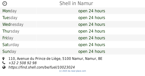
+32 81 20 07 32
website:
total.be
Latitude:
50.4807837
, Longitude:
4.8821553
larger map & directions
read more
nearest Gas station
67 m
Esso
Chée de Louvain 390, Bouge
Gas station
read more
68 m
EXPRESS BOUGE
Chée de Louvain 390, Namur
Gas station
read more
280 m
Shell
Chée de Louvain 350, Namur
Gas station
read more
801 m
Q8 Shop'n Go
Chée de Louvain 494, Namur
Gas station
read more
835 m
Lukoil BOUGE
Chée de Louvain 171, Bouge
Gas station
read more
835 m
Lukoil
Chée de Louvain 171, Bouge
Gas station
read more
1.615 km
Octa+
Chée de Louvain 627, Namur
Gas station
read more
1.798 km
tankpool24
Route de Hannut 86
Gas station
read more
1.814 km
Texaco Bouge-Hannut
Route de Hannut 88, Namur
Gas station
read more
1.875 km
IDS
Route de Hannut, Namur
Gas station
read more
1.922 km
Shell
Avenue du Prince de Liège 110, Namur
Gas station
read more
1.968 km
Total
Avenue de Luxembourg 1, Namur
Gas station
read more
2.073 km
Lukoil Jambes
Avenue du Prince de Liège 48, Namur
Gas station
read more
2.131 km
Q8 easy
Avenue du Prince de Liège 22, Namur
Gas station
read more
2.312 km
Lukoil Jambes II
Chaussée de Liège 561, Namur
Gas station
read more
2.312 km
Lukoil
Chaussée de Liège 561, Namur
Gas station
read more
2.426 km
Total
Chaussée de Waterloo 6, Namur
Gas station
read more
3.331 km
DATS 24
Chaussée de Charleroi 16, Namur
Gas station
read more
3.331 km
DATS 24 Namur Salzinnes
Chaussée de Charleroi 16, Namur
Gas station
read more
3.635 km
Q8
Chée de Louvain 921, Cognelee
Gas station
read more
3.987 km
Avia - Jambes
Rue de Dave 267, Namur
Gas station
read more
4.175 km
Lukoïl
Avenue Joseph Abras 77, Belgrade/namur
Gas station
read more
4.412 km
Texaco
Avenue Joseph Abras 143, Namur
Gas station
read more
4.779 km
E.F.S.
Chaussée de Charleroi, Namur
Gas station
read more
5.89 km
Octa+
Chaussée de Charleroi 476, Malonne
Gas station
read more
📑
all categories
Accounting
Administrative area level 1
Administrative area level 2
Airport
Amusement park
Aquarium
Art gallery
Atm
Bakery
Bank
Bar
Beauty salon
Bicycle store
Book store
Bowling alley
Bus station
Cafe
Campground
Car dealer
Car rental
Car repair
Car wash
Casino
Cemetery
Church
City hall
Clothing store
Colloquial area
Convenience store
Country
Courthouse
Dentist
Department store
Doctor
Electrician
Electronics store
Embassy
Finance
Fire station
Florist
Food
Funeral home
Furniture store
Gas station
General contractor
Grocery or supermarket
Gym
Hair care
Hardware store
Health
Hindu Temple
Home goods store
Hospital
Insurance agency
Jewelry store
Laundry
Lawyer
Library
Light rail station
Liquor store
Local government office
Locality
Locksmith
Lodging
Meal delivery
Meal takeaway
Mosque
Movie rental
Movie theater
Moving company
Museum
Natural feature
Neighborhood
Night club
Painter
Park
Parking
Pet store
Pharmacy
Physiotherapist
Place of worship
Plumber
Point of interest
Police
Political
Post office
Premise
Real estate agency
Restaurant
Roofing contractor
Route
Rv park, camping
School
Shoe store
Shopping mall
Spa
Stadium
Storage
Store
Subpremise
Subway station
Supermarket
Synagogue
Taxi stand
Train station
Transit station
Travel agency
University
Veterinary care
Zoo
sublocality level 1
sublocality level 2
sublocality level 3
↑