Gas station nearby Total
Coronavirus disease (COVID-19) Situation
confirmed cases
4861695
deaths
34376
Belgium
Gas station nearby Total
Total
Chaussée de Liège 1159, Namur Belgium
contacts phone
:
+32
Latitude:
50.4786971
, Longitude:
4.9661147
read more
nearest Gas station
1.517 km
Q8
Rue de Gawday 74, Maizaret
Gas station
read more
1.586 km
Almacen Belgik
Rue de Gawday 85-91, Andenne
Gas station
read more
4.199 km
IDS
Route de Hannut, Namur
Gas station
read more
4.294 km
Texaco Bouge-Hannut
Route de Hannut 88, Namur
Gas station
read more
4.301 km
tankpool24
Route de Hannut 86
Gas station
read more
4.305 km
Total
Rue des Combattants 72, Andenne
Gas station
read more
4.839 km
Lukoil Jambes II
Chaussée de Liège 561, Namur
Gas station
read more
4.839 km
Lukoil
Chaussée de Liège 561, Namur
Gas station
read more
5.457 km
Q8
Rue Docteur Parent 399, Andenne-Sclayn
Gas station
read more
5.54 km
Octa+
Grand-Route 73, Fernelmont
Gas station
read more
6.034 km
Q8
Chée de Louvain 921, Cognelee
Gas station
read more
6.039 km
Q8
Chée de Louvain 931, Namur
Gas station
read more
6.347 km
Hingeon output E42
Grand-Route 6, Fernelmont
Gas station
read more
6.355 km
Lukoil Jambes
Avenue du Prince de Liège 48, Namur
Gas station
read more
6.435 km
Q8 easy
Avenue du Prince de Liège 22, Namur
Gas station
read more
6.513 km
Petroleum Services Belgique sa
Rue des Pieds d'Alouette 7, Namur
Gas station
read more
7.87 km
Avia - Jambes
Rue de Dave 267, Namur
Gas station
read more
9.631 km
Shell Express
Chaussée de Dinant 1137, Namur
Gas station
read more
9.941 km
SLG Petroleum - Bierwart
Rue de Hannut 1,, Fernelmont
Gas station
read more
10.035 km
Lukoïl
Avenue Joseph Abras 77, Belgrade/namur
Gas station
read more
10.436 km
Total
Chaussée de Luxembourg 8, Assesse
Gas station
read more
11.43 km
Total
Rue de Ciney 57J, Ohey
Gas station
read more
12.528 km
Martelange
Rue Georges Emmanuel 51, Namur
Gas station
read more
13.194 km
Total
Route de Ramillies 6, Éghezée
Gas station
read more
13.983 km
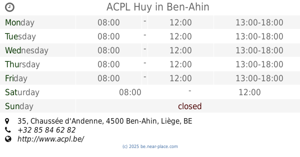
ACPL Huy
Chaussée d'Andenne 35, Ben-Ahin
Gas station
read more
📑
all categories
Accounting
Administrative area level 1
Administrative area level 2
Airport
Amusement park
Aquarium
Art gallery
Atm
Bakery
Bank
Bar
Beauty salon
Bicycle store
Book store
Bowling alley
Bus station
Cafe
Campground
Car dealer
Car rental
Car repair
Car wash
Casino
Cemetery
Church
City hall
Clothing store
Colloquial area
Convenience store
Country
Courthouse
Dentist
Department store
Doctor
Electrician
Electronics store
Embassy
Finance
Fire station
Florist
Food
Funeral home
Furniture store
Gas station
General contractor
Grocery or supermarket
Gym
Hair care
Hardware store
Health
Hindu Temple
Home goods store
Hospital
Insurance agency
Jewelry store
Laundry
Lawyer
Library
Light rail station
Liquor store
Local government office
Locality
Locksmith
Lodging
Meal delivery
Meal takeaway
Mosque
Movie rental
Movie theater
Moving company
Museum
Natural feature
Neighborhood
Night club
Painter
Park
Parking
Pet store
Pharmacy
Physiotherapist
Place of worship
Plumber
Point of interest
Police
Political
Post office
Premise
Real estate agency
Restaurant
Roofing contractor
Route
Rv park, camping
School
Shoe store
Shopping mall
Spa
Stadium
Storage
Store
Subpremise
Subway station
Supermarket
Synagogue
Taxi stand
Train station
Transit station
Travel agency
University
Veterinary care
Zoo
sublocality level 1
sublocality level 2
sublocality level 3
↑