Gas station nearby Total
Belgium
Gas station nearby Total
Total
Boulevard Emile Schevenels 13, Lessines Belgia
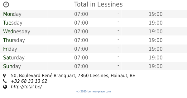
contacts phone
:
+32
Latitude:
50.7118531
, Longitude:
3.8250794
read more
nearest Gas station
480 m
Total LESSINES
boulevard René
Gas station
read more
965 m
Q8 easy
Chaussée de Grammont 26, Lessines
Gas station
read more
1.214 km
Total
Boulevard René Branquart 50, Lessines
Gas station
read more
2.575 km
Esso
Chaussée Gabrielle Richet 230, Lessines
Gas station
read more
4.723 km
ENORA CNG
Chaussée Victor Lampe 183, Lessines
Gas station
read more
5.307 km
Esso
CHAUSSEE VICTOR LAMPE (N57), Lessines
Gas station
read more
5.312 km
Lukoil Lessines
Chaussée Victor Lampe 184-186, Lessines
Gas station
read more
5.644 km
Super Chargeur Tesla
Ath
Gas station
read more
5.958 km
Total
E429 Bxl-Tournai
Gas station
read more
6.689 km
Domicilio Mio
Vloesberg
Gas station
read more
7.469 km
Total tankstation
Hazelaarstraat 3, Geraardsbergen
Gas station
read more
7.469 km
Total
Hazelaarstraat 3, Geraardsbergen
Gas station
read more
8.14 km
Octa+ Geraardsbergen
Guilleminlaan 235, Geraardsbergen
Gas station
read more
8.141 km
Maxime Leroux bvba's Hobby
Guilleminlaan 237, Geraardsbergen
Gas station
read more
8.827 km
Avia - Ath
Chaussée de Bruxelles 178, Ath
Gas station
read more
9.018 km
DATS 24 Ath
Chaussée de Bruxelles 116, Ath
Gas station
read more
10.415 km
Gabriëls
Industrielaan 2, Brakel
Gas station
read more
10.704 km
Gabriëls Brakel
Ronsesestraat, Brakel
Gas station
read more
11.086 km
Gabriëls
Brusselsestraat 146, Brakel
Gas station
read more
13.809 km
Total
Brusselbaan 1A, Steenhuize
Gas station
read more
17.437 km
Gabriëls Maarkedal
Maarkeweg 9, Maarkedal
Gas station
read more
18.758 km
Gabriëls
Leopoldlaan 85, Ninove
Gas station
read more
18.783 km
Q8
Brakelsesteenweg 50, Ninove
Gas station
read more
19.072 km
Shell
Albertlaan 100, Ninove
Gas station
read more
19.96 km
Octa+
Aaltersesteenweg 1, Ninove
Gas station
read more
📑
all categories
Accounting
Administrative area level 1
Administrative area level 2
Airport
Amusement park
Aquarium
Art gallery
Atm
Bakery
Bank
Bar
Beauty salon
Bicycle store
Book store
Bowling alley
Bus station
Cafe
Campground
Car dealer
Car rental
Car repair
Car wash
Casino
Cemetery
Church
City hall
Clothing store
Colloquial area
Convenience store
Country
Courthouse
Dentist
Department store
Doctor
Electrician
Electronics store
Embassy
Finance
Fire station
Florist
Food
Funeral home
Furniture store
Gas station
General contractor
Grocery or supermarket
Gym
Hair care
Hardware store
Health
Hindu Temple
Home goods store
Hospital
Insurance agency
Jewelry store
Laundry
Lawyer
Library
Light rail station
Liquor store
Local government office
Locality
Locksmith
Lodging
Meal delivery
Meal takeaway
Mosque
Movie rental
Movie theater
Moving company
Museum
Natural feature
Neighborhood
Night club
Painter
Park
Parking
Pet store
Pharmacy
Physiotherapist
Place of worship
Plumber
Point of interest
Police
Political
Post office
Premise
Real estate agency
Restaurant
Roofing contractor
Route
Rv park, camping
School
Shoe store
Shopping mall
Spa
Stadium
Storage
Store
Subpremise
Subway station
Supermarket
Synagogue
Taxi stand
Train station
Transit station
Travel agency
University
Veterinary care
Zoo
sublocality level 1
sublocality level 2
sublocality level 3
↑