Gas station nearby Texaco
Belgium
Gas station nearby Texaco
Texaco
Route du Condroz 25, Nandrin Belgium
contacts phone
:
+32
Latitude:
50.5059301
, Longitude:
5.3962248
read more
nearest Gas station
81 m
Vrij/Libre
Rue de Nandrin 5, Nandrin
Gas station
read more
2.27 km
Esso
Route du Condroz 316, Nandrin
Gas station
read more
2.953 km
Q8 Nandrin
Route du Condroz 120, Nandrin
Gas station
read more
3.559 km
Delek Belgium
Route du Condroz 23, Nandrin
Gas station
read more
6.037 km
Total
Route de Strée 86, Modave
Gas station
read more
6.662 km
Esso
Rue du Pont 32, Amay
Gas station
read more
8.645 km
Q8
Rue Sauvenière 55, Ouffet
Gas station
read more
8.954 km
Total
Quai du Halage 73, Flémalle
Gas station
read more
9.181 km
Total
Chaussée de Liège 162, Amay
Gas station
read more
10.832 km
Shell
Quai d'Arona 12, Huy
Gas station
read more
12.008 km
Total
Avenue Reine Astrid 10, Huy
Gas station
read more
12.368 km
SAGA
Avenue de la Concorde 65, Seraing
Gas station
read more
12.692 km
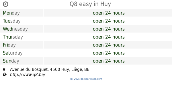
Q8 easy
40, Avenue du Bosquet, Huy
Gas station
read more
13.232 km
Greg Transports
Rue de Flémalle 27, Seraing
Gas station
read more
13.458 km
Total
Rue de Poulseur 21, Comblain-au-Pont
Gas station
read more
14.147 km
De Gheus Michel
Rue de Wanzoul 50, Wanze
Gas station
read more
14.33 km
Lukoil Jemeppe
Rue Sualem Renkin 2, Jemeppe-sur-meuse
Gas station
read more
14.472 km
ESSO JEMEPPE
Rue Sualem Renkin 38, Jemeppe-Sur-Meuse
Gas station
read more
17.001 km
Q8
Quai Timmermans 66, Liege-Sclessin
Gas station
read more
17.737 km
Lukoil Angleur
Rue d'Ougrée 61, Liège
Gas station
read more
17.995 km
Esso
Rue du Plan Incliné 117, Liège
Gas station
read more
19.116 km
Esso
Quai des Ardennes 117, Liège
Gas station
read more
19.319 km
Q8
Rue Grétry 150, Liège
Gas station
read more
19.364 km
Total
Rue des Prémontrés 2, Liège
Gas station
read more
20.472 km
Q8 easy
Rue de Herve 28, Liege-Bressoux
Gas station
read more
📑
all categories
Accounting
Administrative area level 1
Administrative area level 2
Airport
Amusement park
Aquarium
Art gallery
Atm
Bakery
Bank
Bar
Beauty salon
Bicycle store
Book store
Bowling alley
Bus station
Cafe
Campground
Car dealer
Car rental
Car repair
Car wash
Casino
Cemetery
Church
City hall
Clothing store
Colloquial area
Convenience store
Country
Courthouse
Dentist
Department store
Doctor
Electrician
Electronics store
Embassy
Finance
Fire station
Florist
Food
Funeral home
Furniture store
Gas station
General contractor
Grocery or supermarket
Gym
Hair care
Hardware store
Health
Hindu Temple
Home goods store
Hospital
Insurance agency
Jewelry store
Laundry
Lawyer
Library
Light rail station
Liquor store
Local government office
Locality
Locksmith
Lodging
Meal delivery
Meal takeaway
Mosque
Movie rental
Movie theater
Moving company
Museum
Natural feature
Neighborhood
Night club
Painter
Park
Parking
Pet store
Pharmacy
Physiotherapist
Place of worship
Plumber
Point of interest
Police
Political
Post office
Premise
Real estate agency
Restaurant
Roofing contractor
Route
Rv park, camping
School
Shoe store
Shopping mall
Spa
Stadium
Storage
Store
Subpremise
Subway station
Supermarket
Synagogue
Taxi stand
Train station
Transit station
Travel agency
University
Veterinary care
Zoo
sublocality level 1
sublocality level 2
sublocality level 3
↑