Gas station nearby Servicestation Veger
Coronavirus disease (COVID-19) Situation
confirmed cases
4861695
deaths
34376
Belgium
Gas station nearby Servicestation Veger
Servicestation Veger
Waldfeuchterbaan 101, Maria-Hoop Belgium
contacts phone
:
+32
Latitude:
51.0732119
, Longitude:
5.9768909
read more
nearest Gas station
6.257 km
Autohaus Schüren
Hauptstraße, Selfkant
Gas station
read more
7.006 km
Firezone
Rijksweg Noord 3, Echt
Gas station
read more
8.246 km
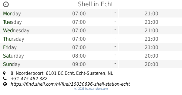
Shell
Noorderpoort 8, Echt
Gas station
read more
8.706 km
tankpool24
Zuiderpoort 12, Echt
Gas station
read more
8.735 km
Esso
Zuiderpoort 12, Echt
Gas station
read more
8.894 km
Esso
A2, Echt
Gas station
read more
9.065 km
De Tenk
Gouverneur Houbenstraat 1, Nieuwstadt
Gas station
read more
9.166 km
carpool maasbracht
Sint Joosterweg 5A, Maasbracht
Gas station
read more
9.259 km
Tinq
Oudeweg 30, Linne
Gas station
read more
10.018 km
AVIA Truck Sittard
Op de Baan 11, Nieuwstadt
Gas station
read more
10.482 km
Firezone
Industrieweg 1, Maasbracht
Gas station
read more
10.787 km
Wenmaekers
Langereweg 17, Born
Gas station
read more
12.063 km
Tinq
Molenweg 26, Wessem
Gas station
read more
13.415 km
Shell Express
Burgemeester Philipslaan 80, Maaseik
Gas station
read more
13.482 km
OrangeGas
Middenweg 100, Sittard
Gas station
read more
14.212 km
Shell
A2, Geleen
Gas station
read more
14.449 km
Total
Elsenburglaan 2, Geleen
Gas station
read more
14.591 km
Verjans & zonen
Venlosesteenweg 373, Kinrooi
Gas station
read more
14.83 km
Esso
Maastrichterstwg 168, Maaseik B
Gas station
read more
15.256 km
Tankstation
Breeërsteenweg 69, Kinrooi
Gas station
read more
15.262 km
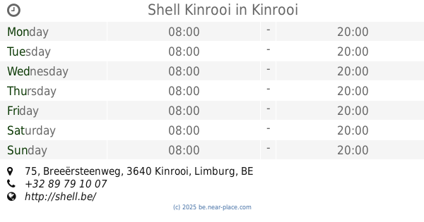
Shell Kinrooi
Breeërsteenweg 75, Kinrooi
Gas station
read more
15.278 km
Shell
Breeërsteenweg 75, Kinrooi
Gas station
read more
15.484 km
Tinq
Mauritslaan 98, Geleen
Gas station
read more
15.717 km
LUKOIL Express Geleen
Mauritslaan 51-53, Geleen
Gas station
read more
16.946 km
Texaco
Nieuwe Postbaan 1, Stein
Gas station
read more
📑
all categories
Accounting
Administrative area level 1
Administrative area level 2
Airport
Amusement park
Aquarium
Art gallery
Atm
Bakery
Bank
Bar
Beauty salon
Bicycle store
Book store
Bowling alley
Bus station
Cafe
Campground
Car dealer
Car rental
Car repair
Car wash
Casino
Cemetery
Church
City hall
Clothing store
Colloquial area
Convenience store
Country
Courthouse
Dentist
Department store
Doctor
Electrician
Electronics store
Embassy
Finance
Fire station
Florist
Food
Funeral home
Furniture store
Gas station
General contractor
Grocery or supermarket
Gym
Hair care
Hardware store
Health
Hindu Temple
Home goods store
Hospital
Insurance agency
Jewelry store
Laundry
Lawyer
Library
Light rail station
Liquor store
Local government office
Locality
Locksmith
Lodging
Meal delivery
Meal takeaway
Mosque
Movie rental
Movie theater
Moving company
Museum
Natural feature
Neighborhood
Night club
Painter
Park
Parking
Pet store
Pharmacy
Physiotherapist
Place of worship
Plumber
Point of interest
Police
Political
Post office
Premise
Real estate agency
Restaurant
Roofing contractor
Route
Rv park, camping
School
Shoe store
Shopping mall
Spa
Stadium
Storage
Store
Subpremise
Subway station
Supermarket
Synagogue
Taxi stand
Train station
Transit station
Travel agency
University
Veterinary care
Zoo
sublocality level 1
sublocality level 2
sublocality level 3
↑