Gas station nearby OCTA+
Belgium
Gas station nearby OCTA+
OCTA+
Avenue Chazallaan 114, Brussel Belgium
contacts phone
:
+32
Latitude:
50.8564851
, Longitude:
4.3896306
read more
nearest Gas station
126 m
Sholy Station Service
Schaerbeek
Gas station
read more
528 m
Shell Express
Leuvensesteenweg 568, Schaarbeek
Gas station
read more
536 m
Shell
Chaussée de Louvain 568, Schaerbeek
Gas station
read more
536 m
Shell
Leuvensesteenweg 568, Schaarbeek
Gas station
read more
545 m
Total
Generaal Wahislaan 30, Schaarbeek
Gas station
read more
545 m
Total
Boulevard Général Wahis 30, Schaerbeek
Gas station
read more
560 m
Texaco Schaerbeek
Schaerbeek
Gas station
read more
628 m
Lukoil Schaerbeek
Chaussée de Louvain 285, Schaerbeek
Gas station
read more
632 m
Gulf Brussels
Schaerbeek
Gas station
read more
632 m
Gulf Brussels
Schaarbeek
Gas station
read more
635 m
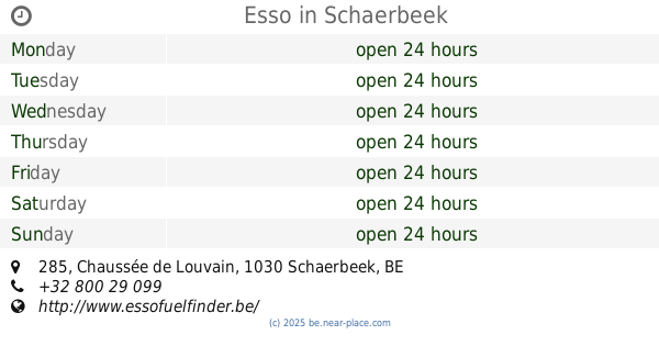
Esso
Chaussée de Louvain 285, Schaerbeek
Gas station
read more
635 m
Esso
Leuvensesteenweg 285, Schaarbeek
Gas station
read more
672 m
Total
Avenue Général Eisenhower 2A, Schaerbeek
Gas station
read more
672 m
Total
Generaal Eisenhowerlaan 2A, Schaarbeek
Gas station
read more
790 m
Shell
Chaussée de Louvain 622, Schaerbeek
Gas station
read more
790 m
Shell
Leuvensesteenweg 622, Schaarbeek
Gas station
read more
1.178 km
Total
Jerusalemstraat 66, Schaarbeek
Gas station
read more
1.178 km
Total
Rue de Jérusalem 66, Schaerbeek
Gas station
read more
1.186 km
Ab+
Schaarbeek
Gas station
read more
1.186 km
Ab+
Schaerbeek
Gas station
read more
1.262 km
Topco
Place de Houffalize 22, Schaerbeek
Gas station
read more
1.262 km
Topco
Houffalizeplein 22, Schaarbeek
Gas station
read more
1.282 km
Petrogold
Schaerbeek
Gas station
read more
1.282 km
Petrogold
Schaarbeek
Gas station
read more
1.967 km
Total
Rue Belliard 86, Bruxelles
Gas station
read more
📑
all categories
Accounting
Administrative area level 1
Administrative area level 2
Airport
Amusement park
Aquarium
Art gallery
Atm
Bakery
Bank
Bar
Beauty salon
Bicycle store
Book store
Bowling alley
Bus station
Cafe
Campground
Car dealer
Car rental
Car repair
Car wash
Casino
Cemetery
Church
City hall
Clothing store
Colloquial area
Convenience store
Country
Courthouse
Dentist
Department store
Doctor
Electrician
Electronics store
Embassy
Finance
Fire station
Florist
Food
Funeral home
Furniture store
Gas station
General contractor
Grocery or supermarket
Gym
Hair care
Hardware store
Health
Hindu Temple
Home goods store
Hospital
Insurance agency
Jewelry store
Laundry
Lawyer
Library
Light rail station
Liquor store
Local government office
Locality
Locksmith
Lodging
Meal delivery
Meal takeaway
Mosque
Movie rental
Movie theater
Moving company
Museum
Natural feature
Neighborhood
Night club
Painter
Park
Parking
Pet store
Pharmacy
Physiotherapist
Place of worship
Plumber
Point of interest
Police
Political
Post office
Premise
Real estate agency
Restaurant
Roofing contractor
Route
Rv park, camping
School
Shoe store
Shopping mall
Spa
Stadium
Storage
Store
Subpremise
Subway station
Supermarket
Synagogue
Taxi stand
Train station
Transit station
Travel agency
University
Veterinary care
Zoo
sublocality level 1
sublocality level 2
sublocality level 3
↑