Gas station nearby J.r.s- Jans Co
Belgium
Gas station nearby J.r.s- Jans Co
J.r.s- Jans Co
2, Kruisbosstraat, 3740, Bilzen, Limburg, BE Belgien
contacts phone
:
+32 89 41 10 55
website:
nebimjrs.be
Latitude:
50.9083502
, Longitude:
5.5219124
larger map & directions
read more
nearest Gas station
51 m
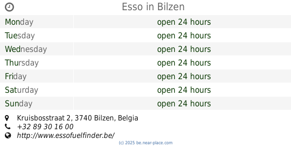
Esso
Kruisbosstraat 2, Bilzen
Gas station
read more
1.166 km
Wagen Poetsen
Oude Siemerstraat 6-16, Bilzen
Gas station
read more
1.445 km
Benzinci Ekrem
Tiendenstraat 3, Zutendaal
Gas station
read more
2.704 km
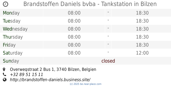
Brandstoffen Daniels bvba - Tankstation
Overwegstraat 2 Bus 1, Bilzen
Gas station
read more
2.707 km
Tankstation DANIELS
Overwegstraat, Bilzen
Gas station
read more
3.107 km
Genker Truck Shop Q8 Station
Henry Fordlaan 50, Genk
Gas station
read more
3.539 km
Q8
Eikelaarstraat 15, Genk
Gas station
read more
3.558 km
IDS Genk
Eikelaarstraat 15, Genk
Gas station
read more
3.718 km
Pollet
Holt 72, Bilzen
Gas station
read more
3.751 km
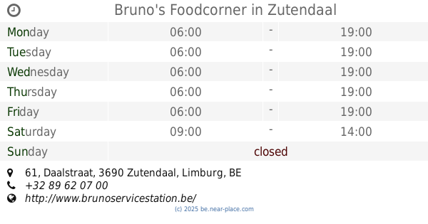
Bruno's Foodcorner
Daalstraat 61, Zutendaal
Gas station
read more
3.753 km
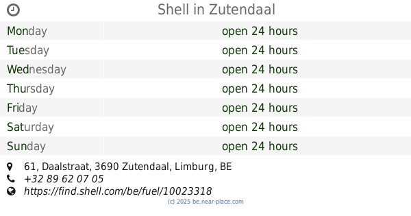
Shell
Daalstraat 61, Zutendaal
Gas station
read more
4.32 km
Texaco
Kapittelstraat 16-24, Bilzen
Gas station
read more
4.708 km
Esso
Nieuwstraat 263, Diepenbeek
Gas station
read more
4.708 km
ESSO DIEPENBEEK
Nieuwstraat 263, Diepenbeek
Gas station
read more
4.83 km
Dubois
Tongersestraat 37, Bilzen
Gas station
read more
4.85 km
Gulf
Tongersestraat 37, Bilzen
Gas station
read more
5.021 km
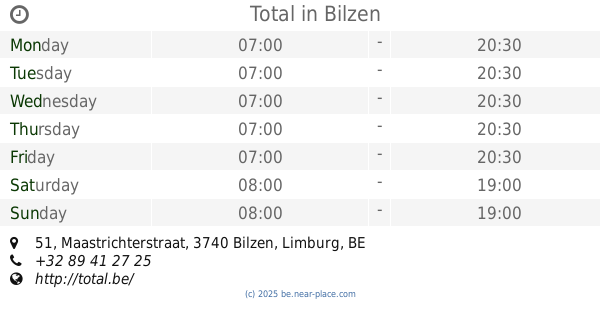
Total
Maastrichterstraat 51, Bilzen
Gas station
read more
5.866 km
Gulf Gellik
Zilverdennenlaan 2, Lanaken
Gas station
read more
7.094 km
Total
Vennestraat 258, Genk
Gas station
read more
10.405 km
Esso Bruno
Henri Esserslaan 10, Genk
Gas station
read more
12.323 km
Shell
Tongerseweg 335, Maastricht
Gas station
read more
13.366 km
CNG Net tankstation
Galjoenweg, Maastricht
Gas station
read more
13.874 km
Comfort Energy
Slachthuiskaai 28, Hasselt
Gas station
read more
14.501 km
Shell
Oude Baan 168, Maasmechelen
Gas station
read more
18.438 km
Ilba bvba
Rijksweg 151, Dilsen-Stokkem
Gas station
read more
📑
all categories
Accounting
Administrative area level 1
Administrative area level 2
Airport
Amusement park
Aquarium
Art gallery
Atm
Bakery
Bank
Bar
Beauty salon
Bicycle store
Book store
Bowling alley
Bus station
Cafe
Campground
Car dealer
Car rental
Car repair
Car wash
Casino
Cemetery
Church
City hall
Clothing store
Colloquial area
Convenience store
Country
Courthouse
Dentist
Department store
Doctor
Electrician
Electronics store
Embassy
Finance
Fire station
Florist
Food
Funeral home
Furniture store
Gas station
General contractor
Grocery or supermarket
Gym
Hair care
Hardware store
Health
Hindu Temple
Home goods store
Hospital
Insurance agency
Jewelry store
Laundry
Lawyer
Library
Light rail station
Liquor store
Local government office
Locality
Locksmith
Lodging
Meal delivery
Meal takeaway
Mosque
Movie rental
Movie theater
Moving company
Museum
Natural feature
Neighborhood
Night club
Painter
Park
Parking
Pet store
Pharmacy
Physiotherapist
Place of worship
Plumber
Point of interest
Police
Political
Post office
Premise
Real estate agency
Restaurant
Roofing contractor
Route
Rv park, camping
School
Shoe store
Shopping mall
Spa
Stadium
Storage
Store
Subpremise
Subway station
Supermarket
Synagogue
Taxi stand
Train station
Transit station
Travel agency
University
Veterinary care
Zoo
sublocality level 1
sublocality level 2
sublocality level 3
↑