Gas station nearby Braine Mazout
Belgium
Gas station nearby Braine Mazout
Braine Mazout
Chaussée de Tubize 64, Braine-l'Alleud Belgium
contacts phone
:
+32
Latitude:
50.6990064
, Longitude:
4.3589536
read more
nearest Gas station
4 m
Lukoil Braine-l'Alleud
Chaussée de Tubize 58, Braine-l'Alleud
Gas station
read more
1.055 km
Shell
Chaussée d'Alsemberg 244, Braine-l'Alleud
Gas station
read more
3.446 km
Total
Chaussée de Nivelles 2, Braine-l'Alleud
Gas station
read more
4.408 km
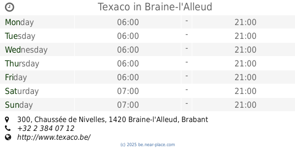
Texaco
Chaussée de Nivelles 300, Braine-l'Alleud
Gas station
read more
4.413 km
Texaco - Braine-l'Alleud
Chaussée de Nivelles 300, Braine-l'Alleud
Gas station
read more
4.962 km
Total
Rue de Mont Saint-Pont 167, Braine-le-Château
Gas station
read more
5.119 km
Total
Waterloosesteenweg 254, Sint-Genesius-Rode
Gas station
read more
5.121 km
Total
Steenweg Op Waterloo, Waterloosesteenweg 254, Sint-Genesius-Rode
Gas station
read more
5.394 km
Lukoil Rhode
Waterloosesteenweg 240, Sint-Genesius-Rode
Gas station
read more
5.648 km
Total
Chaussée de Charleroi 17, Lasne
Gas station
read more
8.796 km
Q8
Alsembergsesteenweg 66, Linkebeek
Gas station
read more
9.69 km
Total
Bergensesteenweg 441, Halle
Gas station
read more
9.873 km
Shop 'n Go Ukkel
Waterloosesteenweg 1389, Ukkel
Gas station
read more
10.637 km
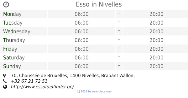
Esso
Chaussée de Bruxelles 70, Nivelles
Gas station
read more
10.831 km
Lukoil Dieweg
Dieweg/Avenue Wolvendael, Bruxelles
Gas station
read more
11.169 km
Q8 Station-Service
Rue de Mons 126, Tubize
Gas station
read more
12.921 km
Contrôle technique
Rue Bollinckx 314, Forest
Gas station
read more
13.57 km
Total
Internatlaan, Boulevard International 11, Anderlecht
Gas station
read more
13.577 km
Texaco
Chaussée de Vleurgat 218, Bruxelles
Gas station
read more
13.67 km
Shell Express
Boulevard Industriel 122, Anderlecht
Gas station
read more
13.671 km
Lukoil Vorst Brits Tweedeleger
Brits Tweedelegerlaan 15, Vorst
Gas station
read more
14.148 km
Texaco
Vorstlaan 320, Oudergem
Gas station
read more
14.669 km
Total
Gebroeders Legrainlaan 76, Sint-Pieters-Woluwe
Gas station
read more
15.025 km
Total
Tweestationsstraat 79A, Anderlecht
Gas station
read more
18.233 km
Total
Leuvensesteenweg 10A, Wezembeek-Oppem
Gas station
read more
📑
all categories
Accounting
Administrative area level 1
Administrative area level 2
Airport
Amusement park
Aquarium
Art gallery
Atm
Bakery
Bank
Bar
Beauty salon
Bicycle store
Book store
Bowling alley
Bus station
Cafe
Campground
Car dealer
Car rental
Car repair
Car wash
Casino
Cemetery
Church
City hall
Clothing store
Colloquial area
Convenience store
Country
Courthouse
Dentist
Department store
Doctor
Electrician
Electronics store
Embassy
Finance
Fire station
Florist
Food
Funeral home
Furniture store
Gas station
General contractor
Grocery or supermarket
Gym
Hair care
Hardware store
Health
Hindu Temple
Home goods store
Hospital
Insurance agency
Jewelry store
Laundry
Lawyer
Library
Light rail station
Liquor store
Local government office
Locality
Locksmith
Lodging
Meal delivery
Meal takeaway
Mosque
Movie rental
Movie theater
Moving company
Museum
Natural feature
Neighborhood
Night club
Painter
Park
Parking
Pet store
Pharmacy
Physiotherapist
Place of worship
Plumber
Point of interest
Police
Political
Post office
Premise
Real estate agency
Restaurant
Roofing contractor
Route
Rv park, camping
School
Shoe store
Shopping mall
Spa
Stadium
Storage
Store
Subpremise
Subway station
Supermarket
Synagogue
Taxi stand
Train station
Transit station
Travel agency
University
Veterinary care
Zoo
sublocality level 1
sublocality level 2
sublocality level 3
↑