Food nearby culinaire gevoel
Coronavirus disease (COVID-19) Situation
confirmed cases
4861695
deaths
34376
Belgium
Food nearby culinaire gevoel
culinaire gevoel
Anderenbroek 70, Haaltert Belgium
contacts phone
:
+32
Latitude:
50.894866
, Longitude:
4.025854
read more
nearest Food
1.993 km
Belcolade
Industrielaan 16
Food
read more
2.33 km
Classic Design Rental
Churchillsteenweg 18, Aalst
Food
read more
3.007 km
Be-Fresh Catering
Iddergemstraat 59, Denderleeuw
Food
read more
3.145 km
Lox / Wouter
Keppestraat 35, Aalst
Food
read more
3.211 km
Traiteur Pomelo
Edestraat 115, Haaltert
Food
read more
3.351 km
BOUJEBBAR
Alfons van de Maelestraat 5, Aalst
Food
read more
3.491 km
Aquarius Age Company Belgium cvba
Kareelstraat 48, Aalst
Food
read more
4.092 km
Sterck / Richard
Oostdorpstraat 68, Erpe-Mere
Food
read more
4.248 km
Agneessens / C.
Parklaan 41, Aalst
Food
read more
4.418 km
Buyl-Van Den Broeck bvba
Nijverheidszone Begijnenmeers 39/A, Liedekerke
Food
read more
4.622 km
't Hof Gotegem
Landries 199, Erpe-Mere
Food
read more
4.767 km
A La Minute
Keizersplein 15, Aalst
Food
read more
4.846 km
Green Carrot
Gentsestraat 31/11, Aalst
Food
read more
4.888 km
Syral
Burchtstraat 10, Aalst
Food
read more
4.95 km
Small Brewery De Glazen Toren
Glazentorenweg 11, Erpe-Mere
Food
read more
5.795 km
L' Atelier du Pain
Pamelstraat-Oost 430, Ninove
Food
read more
6.604 km
Vlassenbroeck
Van der Schuerenstraat 106, Ninove
Food
read more
7.15 km
Traiteur Ronny
Bellestraat 206, Affligem
Food
read more
8.318 km
Galerie Cammu Wereldwijnen
Mutsaardstraat 6a, Herzele
Food
read more
9.693 km
Wyns Drinks Service
Kerkstraat 41, Ternat
Food
read more
13.349 km
Wijnendaele / Xavier
Sint-Amandusweg 12, Zottegem
Food
read more
14.769 km
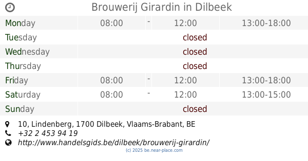
Brouwerij Girardin
Lindenberg 10, Dilbeek
Food
read more
15.08 km
Hoerens / D.
Gaverland 26, Zottegem
Food
read more
16.254 km
Lean meat products
Kasterstraat 55, Wetteren
Food
read more
17.019 km
Van Den Bossche / Filip
Karmelietenstraat 7, Geraardsbergen
Food
read more
📑
all categories
Accounting
Administrative area level 1
Administrative area level 2
Airport
Amusement park
Aquarium
Art gallery
Atm
Bakery
Bank
Bar
Beauty salon
Bicycle store
Book store
Bowling alley
Bus station
Cafe
Campground
Car dealer
Car rental
Car repair
Car wash
Casino
Cemetery
Church
City hall
Clothing store
Colloquial area
Convenience store
Country
Courthouse
Dentist
Department store
Doctor
Electrician
Electronics store
Embassy
Finance
Fire station
Florist
Food
Funeral home
Furniture store
Gas station
General contractor
Grocery or supermarket
Gym
Hair care
Hardware store
Health
Hindu Temple
Home goods store
Hospital
Insurance agency
Jewelry store
Laundry
Lawyer
Library
Light rail station
Liquor store
Local government office
Locality
Locksmith
Lodging
Meal delivery
Meal takeaway
Mosque
Movie rental
Movie theater
Moving company
Museum
Natural feature
Neighborhood
Night club
Painter
Park
Parking
Pet store
Pharmacy
Physiotherapist
Place of worship
Plumber
Point of interest
Police
Political
Post office
Premise
Real estate agency
Restaurant
Roofing contractor
Route
Rv park, camping
School
Shoe store
Shopping mall
Spa
Stadium
Storage
Store
Subpremise
Subway station
Supermarket
Synagogue
Taxi stand
Train station
Transit station
Travel agency
University
Veterinary care
Zoo
sublocality level 1
sublocality level 2
sublocality level 3
↑