Food nearby Belgocatering
Coronavirus disease (COVID-19) Situation
confirmed cases
4861695
deaths
34376
Belgium
Food nearby Belgocatering
Belgocatering
Wijngaardveld 16, Aalst Belgium
contacts phone
:
+32
Latitude:
50.9565589
, Longitude:
4.0398728
read more
nearest Food
246 m
Fun Rent
Wijngaardveld 4, Aalst
Food
read more
619 m
G.D.A. Systems
Victor Bocquéstraat 7, Aalst
Food
read more
1.168 km
Belki
Wijngaardveld 50, Aalst
Food
read more
1.575 km
BELGIAN BLUE
Hoveniersstraat 57, Aalst
Food
read more
1.805 km
Cochez bvba
Vrijheidstraat 17, Aalst
Food
read more
1.959 km
Loro Bollono Traiteur
Volksverheffingstraat 73, Aalst
Food
read more
2.107 km
Green Carrot
Gentsestraat 31/11, Aalst
Food
read more
2.161 km
Syral
Burchtstraat 10, Aalst
Food
read more
2.164 km
A La Minute
Keizersplein 15, Aalst
Food
read more
2.776 km
LEEFLANK
Bosstraat 97, Lede
Food
read more
2.808 km
Agneessens / C.
Parklaan 41, Aalst
Food
read more
3.438 km
Aquarius Age Company Belgium cvba
Kareelstraat 48, Aalst
Food
read more
4.216 km
Traiteur Eddy
Keibergkerkweg 4, Lede
Food
read more
4.265 km
BOUJEBBAR
Alfons van de Maelestraat 5, Aalst
Food
read more
4.364 km
Lox / Wouter
Keppestraat 35, Aalst
Food
read more
4.613 km
Classic Design Rental
Churchillsteenweg 18, Aalst
Food
read more
4.68 km
Barry Callebaut Belgium
Aalstersestraat 122, Lebbeke
Food
read more
5.05 km
Details Chocolatier
Gentsesteenweg 274, Erpe-Mere
Food
read more
6.37 km
Traiteur Pomelo
Edestraat 115, Haaltert
Food
read more
9.427 km
Traiteur Ronny
Bellestraat 206, Affligem
Food
read more
12.308 km
Lean meat products
Kasterstraat 55, Wetteren
Food
read more
15.57 km
Brouwerij Mort Subite
Lierput 1, Asse
Food
read more
16.345 km
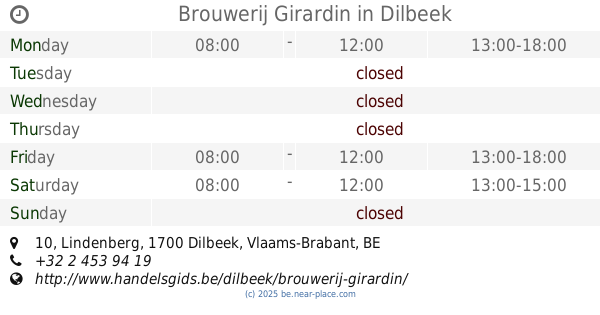
Brouwerij Girardin
Lindenberg 10, Dilbeek
Food
read more
17.069 km
Onafhankelijk distributeur Herbalife Dominique Valcke
Eekhoekstraat 89, Laarne
Food
read more
19.552 km
Hoerens / D.
Gaverland 26, Zottegem
Food
read more
📑
all categories
Accounting
Administrative area level 1
Administrative area level 2
Airport
Amusement park
Aquarium
Art gallery
Atm
Bakery
Bank
Bar
Beauty salon
Bicycle store
Book store
Bowling alley
Bus station
Cafe
Campground
Car dealer
Car rental
Car repair
Car wash
Casino
Cemetery
Church
City hall
Clothing store
Colloquial area
Convenience store
Country
Courthouse
Dentist
Department store
Doctor
Electrician
Electronics store
Embassy
Finance
Fire station
Florist
Food
Funeral home
Furniture store
Gas station
General contractor
Grocery or supermarket
Gym
Hair care
Hardware store
Health
Hindu Temple
Home goods store
Hospital
Insurance agency
Jewelry store
Laundry
Lawyer
Library
Light rail station
Liquor store
Local government office
Locality
Locksmith
Lodging
Meal delivery
Meal takeaway
Mosque
Movie rental
Movie theater
Moving company
Museum
Natural feature
Neighborhood
Night club
Painter
Park
Parking
Pet store
Pharmacy
Physiotherapist
Place of worship
Plumber
Point of interest
Police
Political
Post office
Premise
Real estate agency
Restaurant
Roofing contractor
Route
Rv park, camping
School
Shoe store
Shopping mall
Spa
Stadium
Storage
Store
Subpremise
Subway station
Supermarket
Synagogue
Taxi stand
Train station
Transit station
Travel agency
University
Veterinary care
Zoo
sublocality level 1
sublocality level 2
sublocality level 3
↑